Breathtaking Rock Formations and Arches
Experience one of the most unique nature preserves in the United States in the picturesque Utah wilderness
Arches National Park is located in Southern Utah and was established as a national park in 1971. It is an absolutely amazing nature preserve that has a lot to offer. Here you will see stunning towering rock formations, massive steep rock walls and, as the name suggests, many magnificent natural rock arches.
Utah is probably the American state, alongside Alaska, that has the most spectacular nature. Out of the many nature preserves in the state, Arches National Park is definitely one of the most beautiful and versatile with its many different types of formations
Geology: The Creation of the Amazing Scenery
Arches National Park lies on top of an underground salt bed which is the reason for the arches, spires, fins and various amazing rock formations throughout the park. The salt bed is hundreds of metres deep and was deposited across the Colorado Plateau 300 million years ago when a sea flowed into the region and then eventually evaporated. Over millions of years, residue from floods, weathering and oceans that came and went covered the salt bed. The rubble was compressed as rock.
Salt under pressure is unstable and the salt bed couldn’t handle weight of the massive cover of rock. The salt layers shifted, buckled, liquefied and was redeposited. The rock layers were then thrusted upward as domes and whole sections fell into cavities.
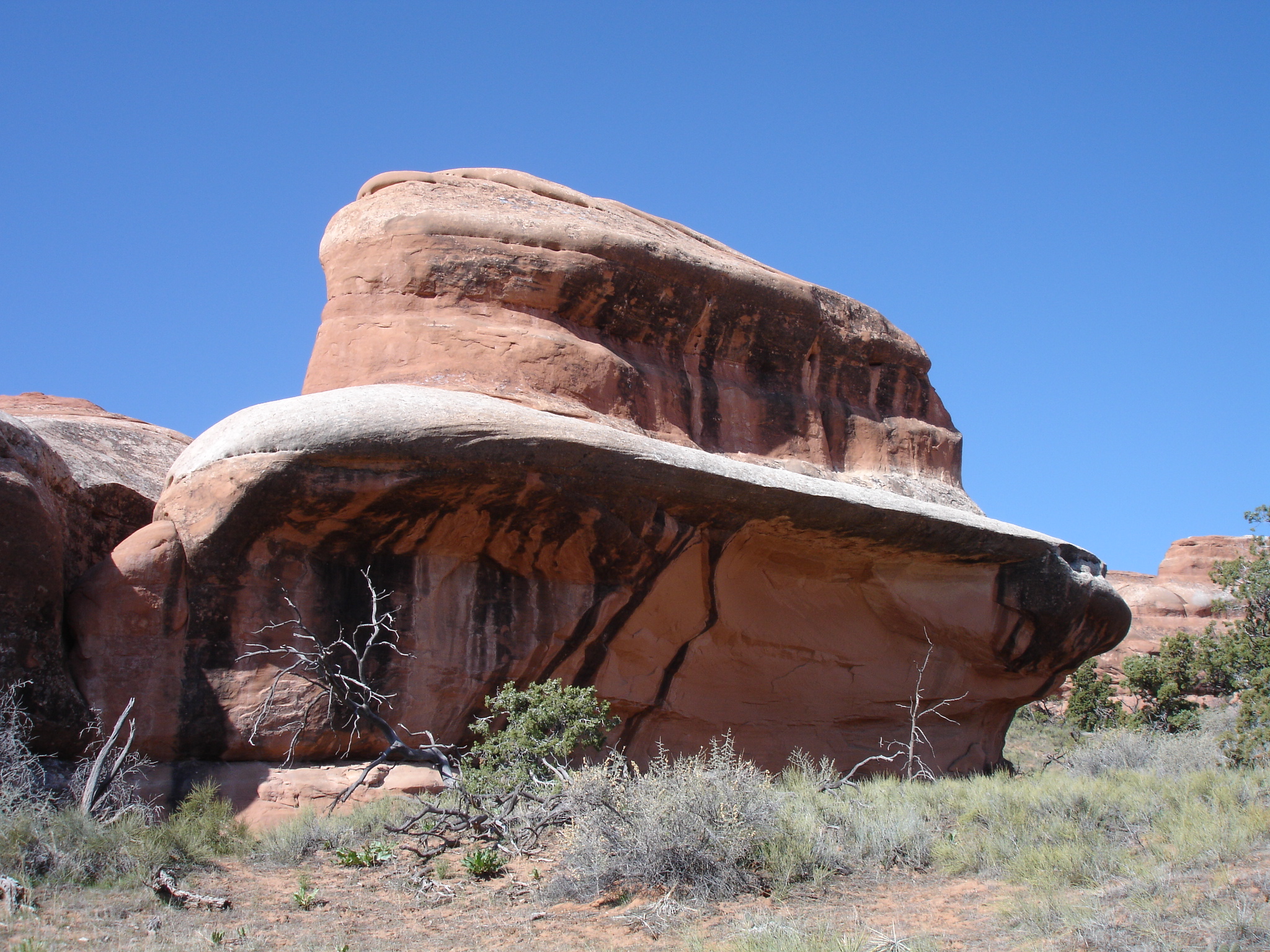
Faults deep in the Earth made the surface even more unstable. These faults caused vertical cracks which later contributed to the creation of the arches. Erosion on the surface removed some of the younger layers of rock. Most of the major formations seen in the park are salmon-coloured Entrada Sandstone or pale yellow-brown Navajo Sandstone. They stand like a layer cake over most of the park.
These layers can be seen in the rocks if you take a closer look. The Entrada Formations are divided into different members. A member in a geological sense is a lithostratigraphic unit. Sequences of sedimentary and volcanic rocks are subdivided by their lithology. The lithology of a rock is determined by characteristics visible in outcrop or core samples based on colour, texture, grain size or composition. A member is a named lithologically distinct part of a formation. Mind you, that not all formations are subdivided in this way.
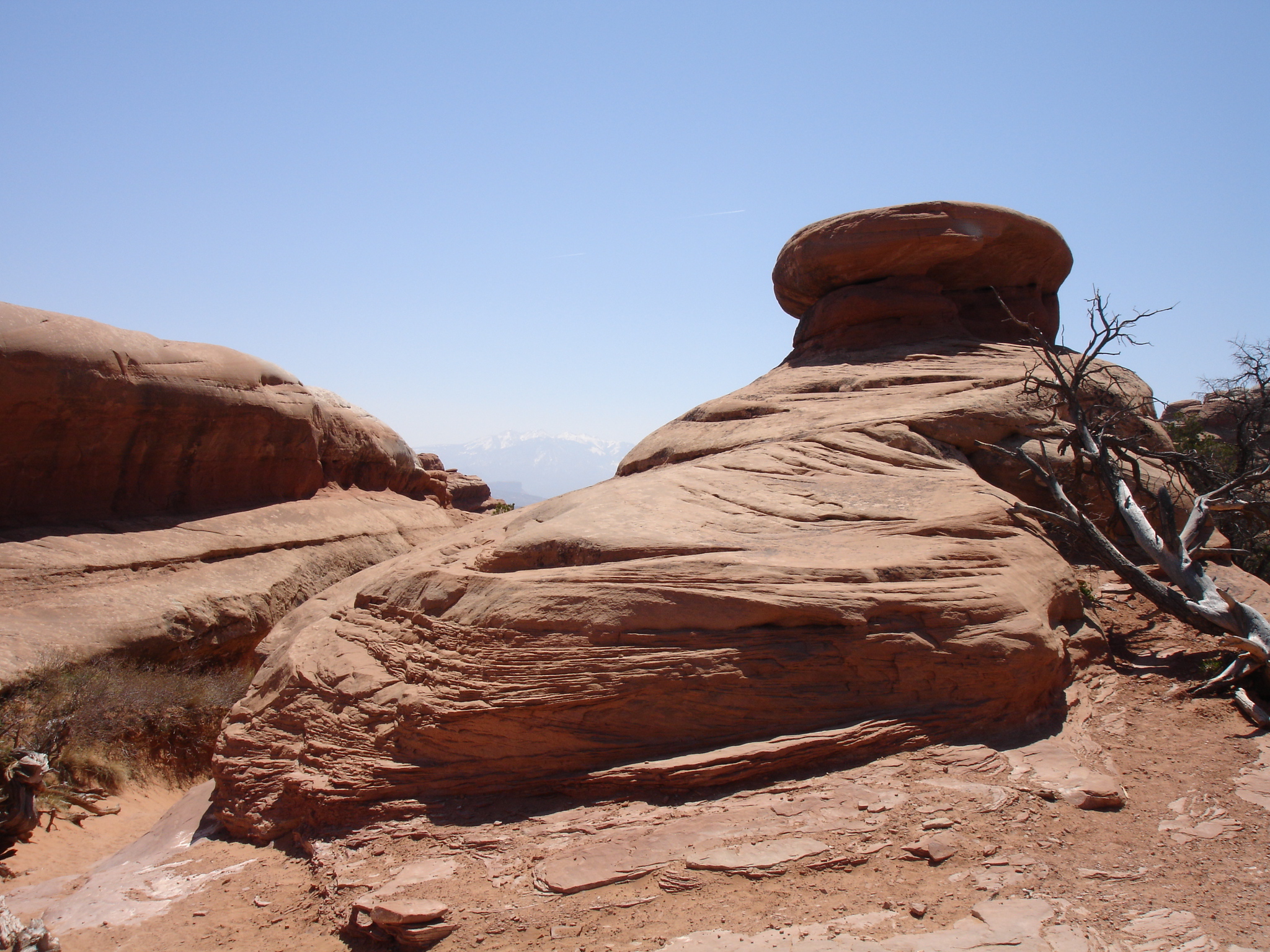
Over time water seeped into superficial cracks, joints and folds. Ice formed and expanded and pressured the rock, breaking off bits and pieces. Wind later cleared away the particles and left some amazing freestanding fins.

Winds and water then attacked the fins until cementing rock fell out together with chunks of rock. Many of these fins collapsed other remained in spite of the missing sections and the result is the stunning arches. Pothole arches are formed by chemical weathering as water collects in natural depression and in time cuts through to the layer below.
The Soil is Alive…Don’t Spoil the Soil
The soil is has a biological crust which can be damaged if you step on it. Therefore please be aware of where you walk and stay on the trails. It’s a dark crust which was once called cryptobiotic soil and it covers a lot of the desert. It’s composed by cyanobacteria, lichen, algae and fungi. This combination fights erosion, absorbs moisture and provides nitrogen and other nutrients for the plants. Therefore be careful you don’t ruin these organism as they give life to plants which attracts the animals.
Vegetation and Animals Among the Sandstone
When you are walking around in the park among all the amazing sandstone formations in the desolate landscape you will notice the presents of a fair bit of vegetation. You will see pinyon and gnarled juniper trees or wildflowers in April to July if the conditions are right.
The mammals are in most cases active at night but you may see rodents, reptiles, mule deer, kit foxes or jack rabbits during the day. Also birds like blue pinyon jays or golden eagles can be seen.
History: The Natives and the Settlers
About 2,000 years ago the region was the frontier of two agricultural cultures of the Anasazi and Fremont Indians. The Anasazi Indians have been credited for the cliff pueblos throughout Arizona, New Mexico, Colorado and Utah. Today the Hopi Indians claim that the Anasazi people were their ancestors.
The Fremont Indians had a close connection with the Ancient Puebloans and their social structure was small and loosely organised. They were known for maintaining a hunting and gathering lifestyle supplemented with farming. At around 1300 both tribes had moved further south and were replaced by Utes and Paiutes who occupied the area until the European settlers arrived.
The Ute people searched the desert for animals and plants for food and for stone to be used for tools and weapons. They left traces of their presence on a few pictograph and petroglyph panels.
The first European explorers to visit the region were the Spaniards. The Spanish empire of the new world expanded and they needed new routes to their California missions through the deserts. One of the routes was known as the Old Spanish Trail and went from Santa Fe to Los Angeles. They also came looking for minerals to increase their wealth.
The Spaniards came as close to the region as the Colorado River in the 1500s and 1700s. The first reliable date for explorers within present day Arches National Park goes back to 9 June 1844 where French-American fur trapper Denis Julien engraved the date and his name onto rocks throughout the Southwest. He was over 60 when he explored the region’s stream and canyons trapping beaver pelts. The furs were very expensive due to the fashion in men’s hats at the time.
Many other traders and fur trappers rode through the Moab region on their horses for decades without settling. In 1855 the Mormon Church established an outpost called Elk Mountain Mission in present day Moab. Due to a conflict with the local Ute Indians they had to abandon the post.
In the 1880s and 1890s Moab was permanently settled by ranchers, prospectors and farmers. Ranchers found wealth as grasses for cattle and sheep. One of the settlers and ranchers, civil war veteran John Wesley Wolfe, built a cabin near Salt Wash where it can still be seen today as evidence of the early ranchers. It is known as Wolf Ranch. He operated his ranch here with his son Fred for more than 20 years.
Exploring and Visiting Arches National Park
When you are going to the southern part of Utah it is highly recommended that you do several of the national parks. You can easily spend a couple of days in Arches National Park as there are plenty of hiking trails to go on and you will be amazed by the beauty that’s for sure.
It really depends on in which direction you are entering Utah from, but you could start in Las Vegas, drive through Nevada to Utah and do Zion and Bryce Canyon National Parks, then Arches National Park, Castle Valley, Canyonlands National Park, Monument Valley and then go back to Las Vegas through Grand Canyon National Park in Arizona. You can also join an organised tour doing this itinerary. By doing all the areas mentioned you will get a big bang for the buck.
The closest major town to Arches National Park is Moab which is also a neat little place to check out. An option could be to camp and book a hotel here. There are a couple of restaurants and pubs a as well which are cool to check out as it will be an experience to be out on the town in the wild west.
Arches Scenic Drive
When you drive into Arches National Park you will be passing several amazing rock formations on the way which are easy accessible from the road, and you can also make stops and take photos. It is known as Arches Scenic Drive which really says it all. Balanced Rock is one of the many fascinating formations you will encounter. Have a stop here and take some shots. Balanced Rock is 39 metres (128 ft) tall and is surrounded by other cool rock formations and a tower as well on a platform. You can also do a short hike up to the rock and around it in a loop.
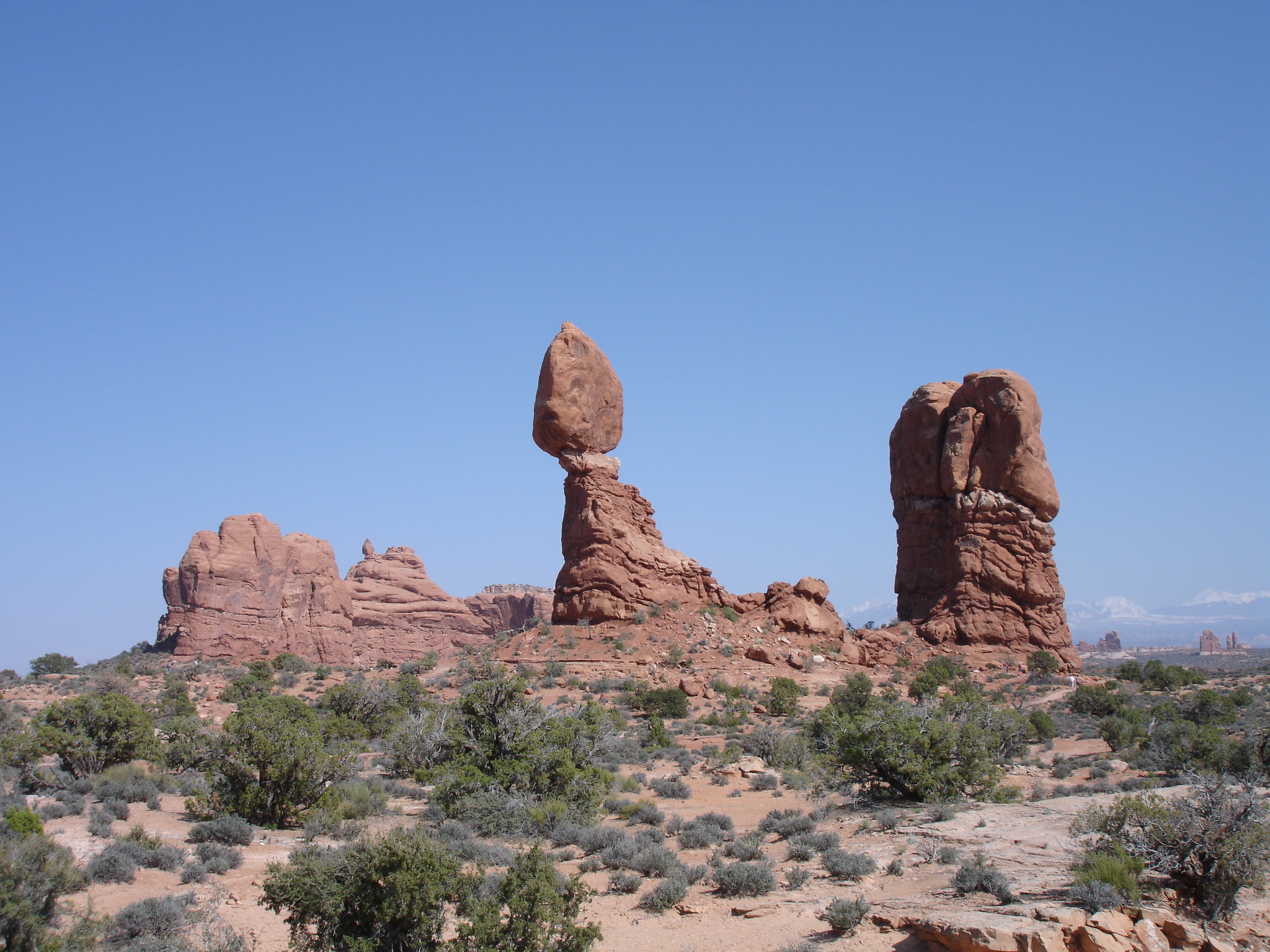
If you look closely at Balanced Rock and the neighbouring tower, you will see a beige/tan line across both rocks approximately a bit above half way up the rocks. These lines separate the eras represented in the rocks. The top part is a Slick Rock Member and the bottom is a Dewey Bridge Member both of the Entrada Formation.
The Windows and Much More
Another option is driving down to the Window Road which is just around the corner from Balanced Rock. This will take you past sights such as the Garden of Eden and the Parade of Elephants. At the end, the road will go in a loop. You can park at the Windows parking area and commence your hike towards the North Window, South Window and Turret Arch which is highly recommended. Afterwards you can continue on the hiking trail to Double Arch. You can walk from the Windows trail but you can also drive down to the Double Arch parking area.
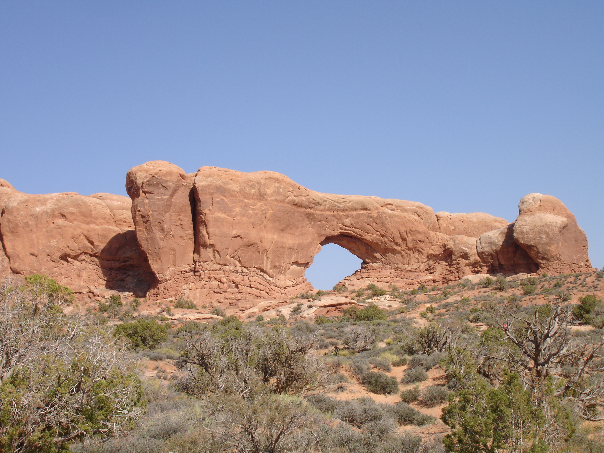
The hike down to the Windows is easy and moderate. It’s on gravel trail with a gentle climb and some steeper section towards end with some steps when getting close to the North and South Windows. The trail is a 1.6 km (1 mile) loop which will lead you to the Window and Turret Arch. This is a great way to experience three massive arches on a trail that is not too strenuous. The hike will probably take you 30 to 60 minutes.
When you continue onward to Double Arch, you will see many amazing rock formations on the way. Double Arch is very impressive as it is two arches in one. The only challenge down here is that it probably will be pretty crowded so it is unlikely that you will get photos of the arch without any people in it.

If you start the hike from the Double Arch parking area it will be a 0.8 km (0.5 mile) return trip which will take you at least about 30 minutes as you want to have a stroll around to really take in this magnificent arch. The trail is a pretty level and sandy. You will be impressed as it is two massive arch spans which are joined at one end. You can climb up the arch as well to have a closer look.
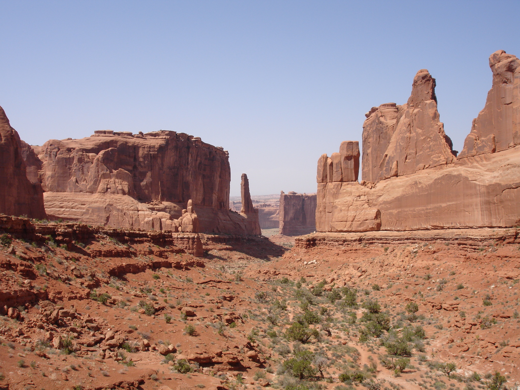
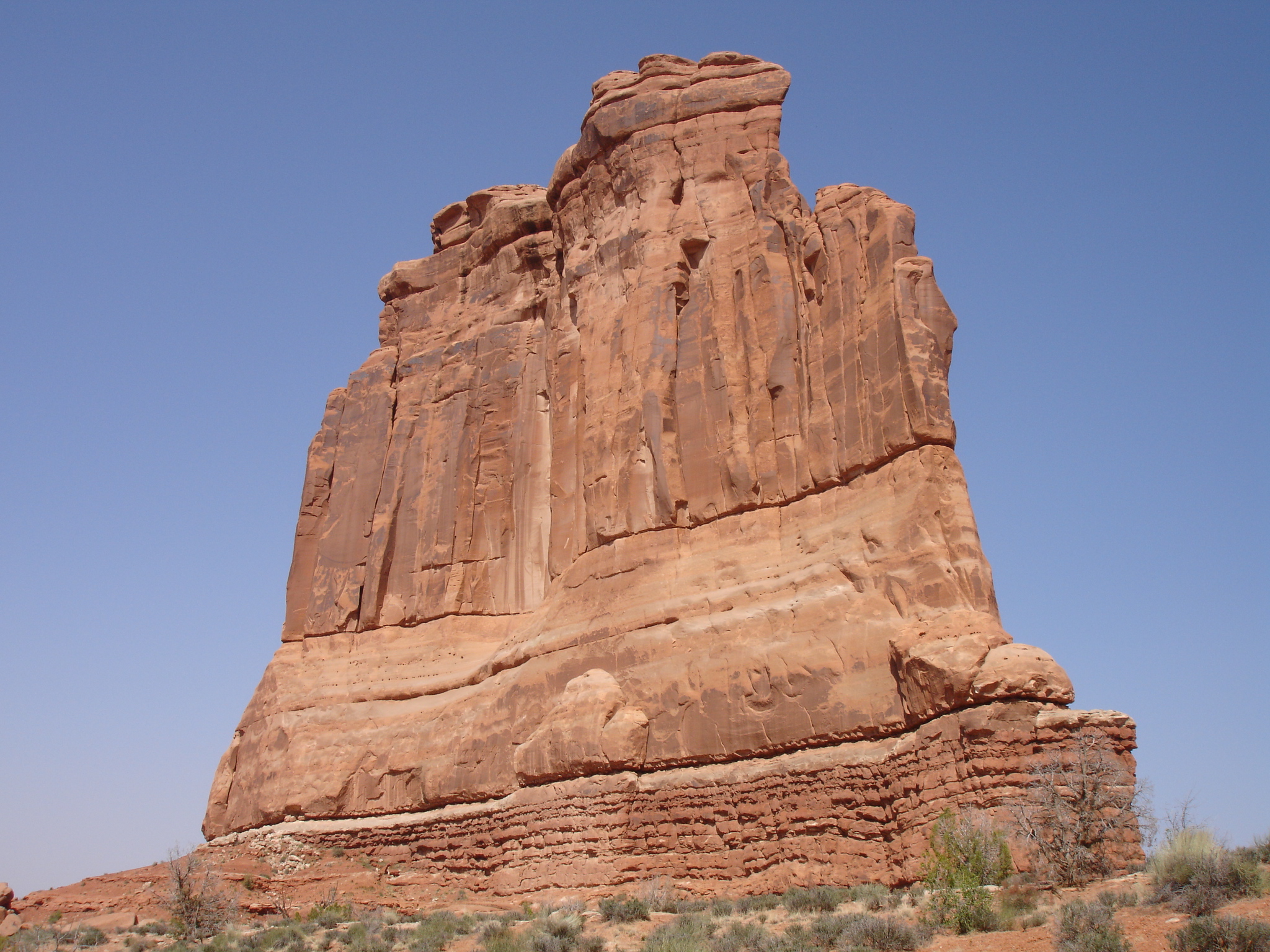
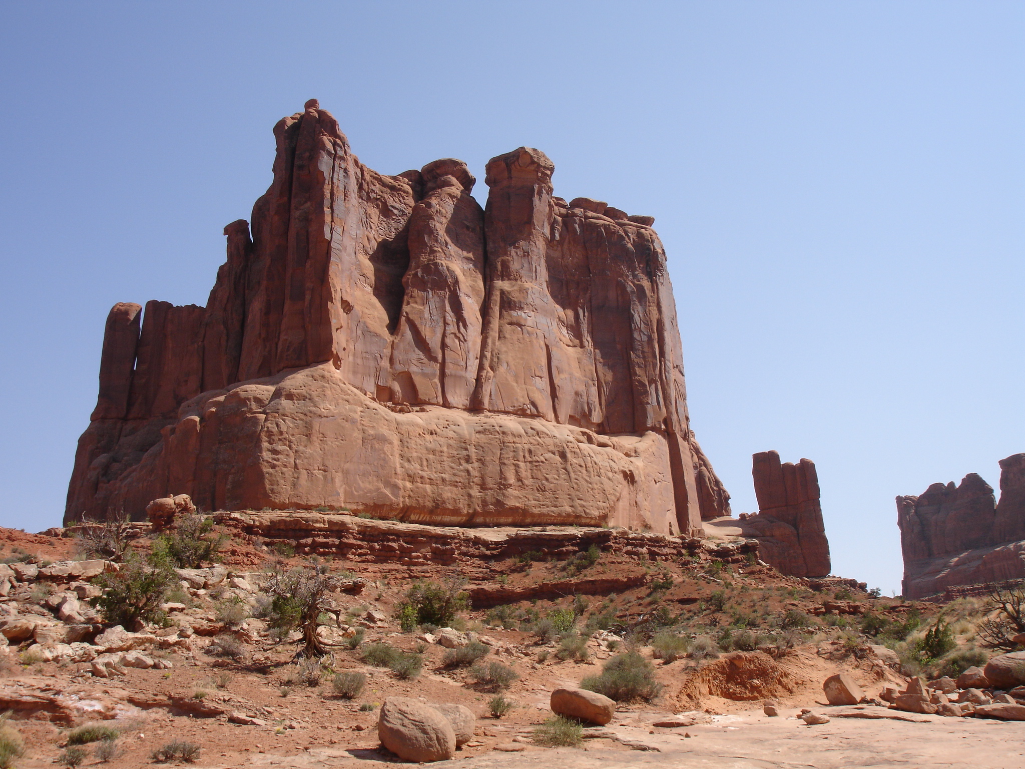
Park Avenue
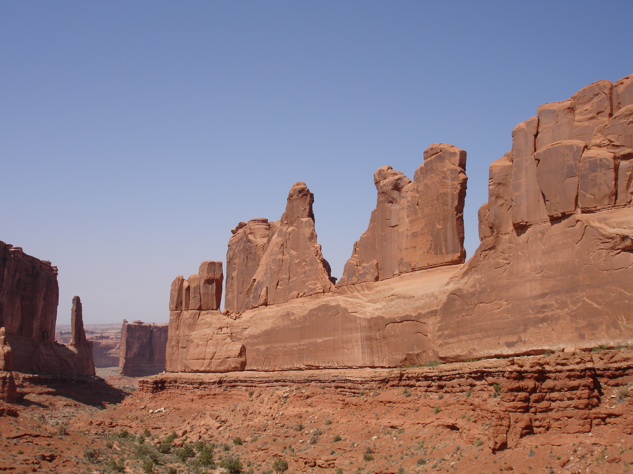
If you want to do a moderate hike you can do the Park Avenue Trail. This is one of the highlights of the park as you will see some stunning steep rock walls, amazing buttes and interesting formations. The hike starts at the Park Avenue parking area and ends at the Courthouse Towers parking area. It’s a 1.6 km (1 mile) stretch and it is not strenuous. You can also return to the Park Avenue parking area if you have a car parked there.

When you start on the trail, have a look around. Note the amazing rock formations to the sides and behind you. So cool. At the starting point you will have a view of the wash on which you will be walking down towards Courthouse Towers. This is an absolutely breath taking view and is probably one of the most spectacular in the United States.
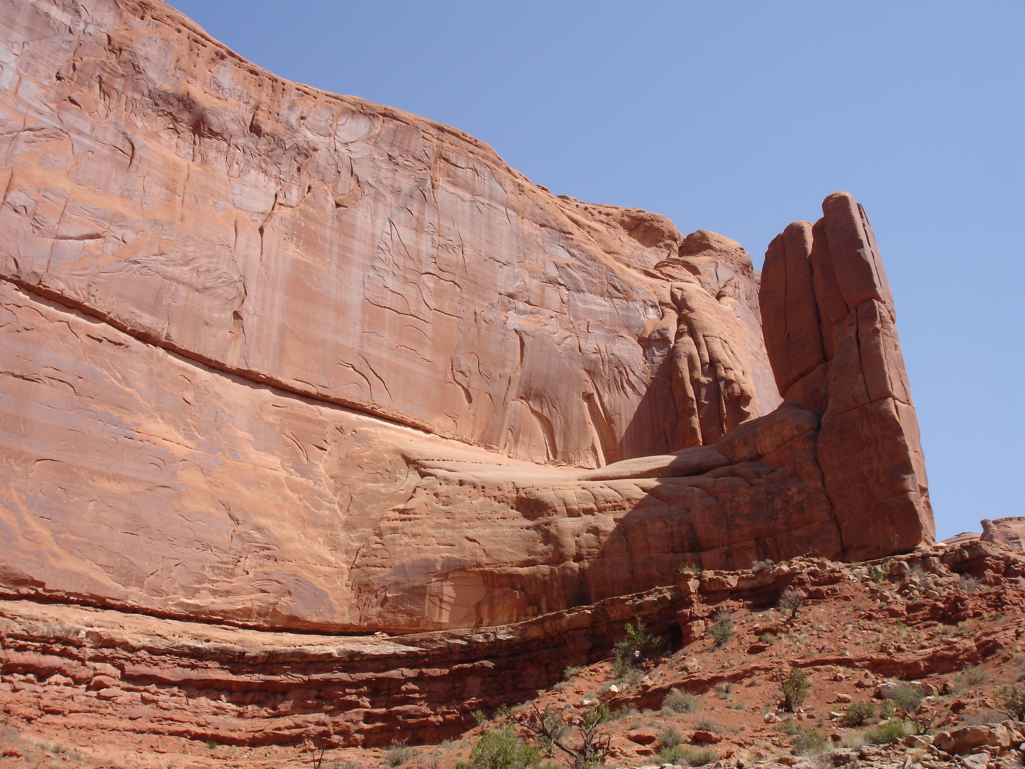
On each side of the wash you will see towering steep rock walls surrounding the wash. The left is dominated by mesas and the right is predominately a thin towering wall. This is known as a sandstone fin. It is a solid sandstone cliff which is called Slick Rock member sandstone of Entrada sandstone. At the bottom of the fin you will see a thin-bedded interval which represents interbedded siltstones and sandstones of the Dewey Bridge Member of Entrada sandstone. Such an amazing sight and a bit unreal.
Going down the wash you should take your time. Take in the scenery, take shots of the rock walls from all sorts of angles, note bush and the odd threes here and there. Amazing how they can grow in this environment. Also check out the multi-layerd rock in some parts of the ground, the dried out pot holes and the smooth surface of the floor. This clearly documents that it’s a wash and when it rains it will come down this way which is also the reason for the presence of the trees. Remember to look back and check out the area you can from and take in the view as well.
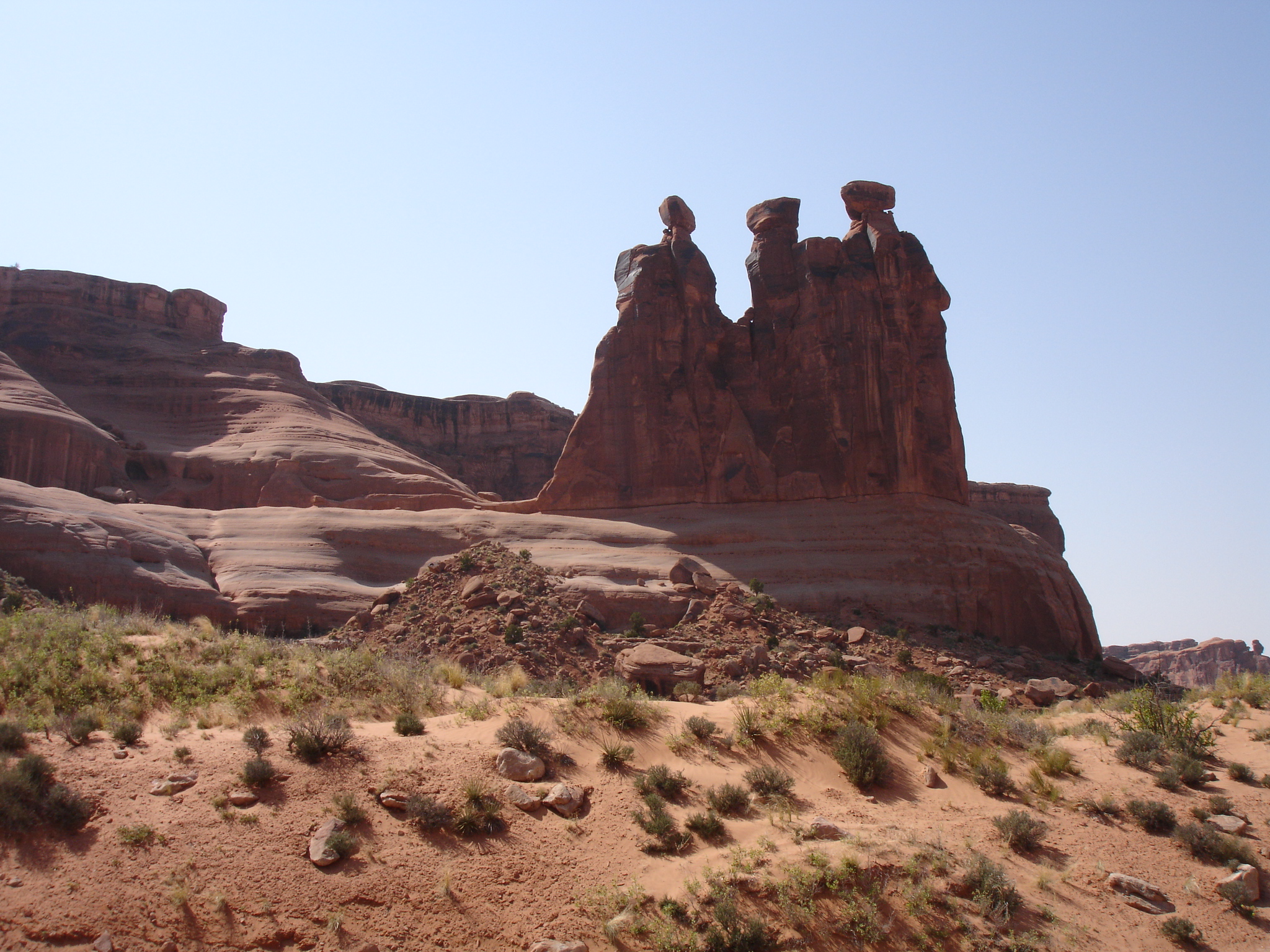
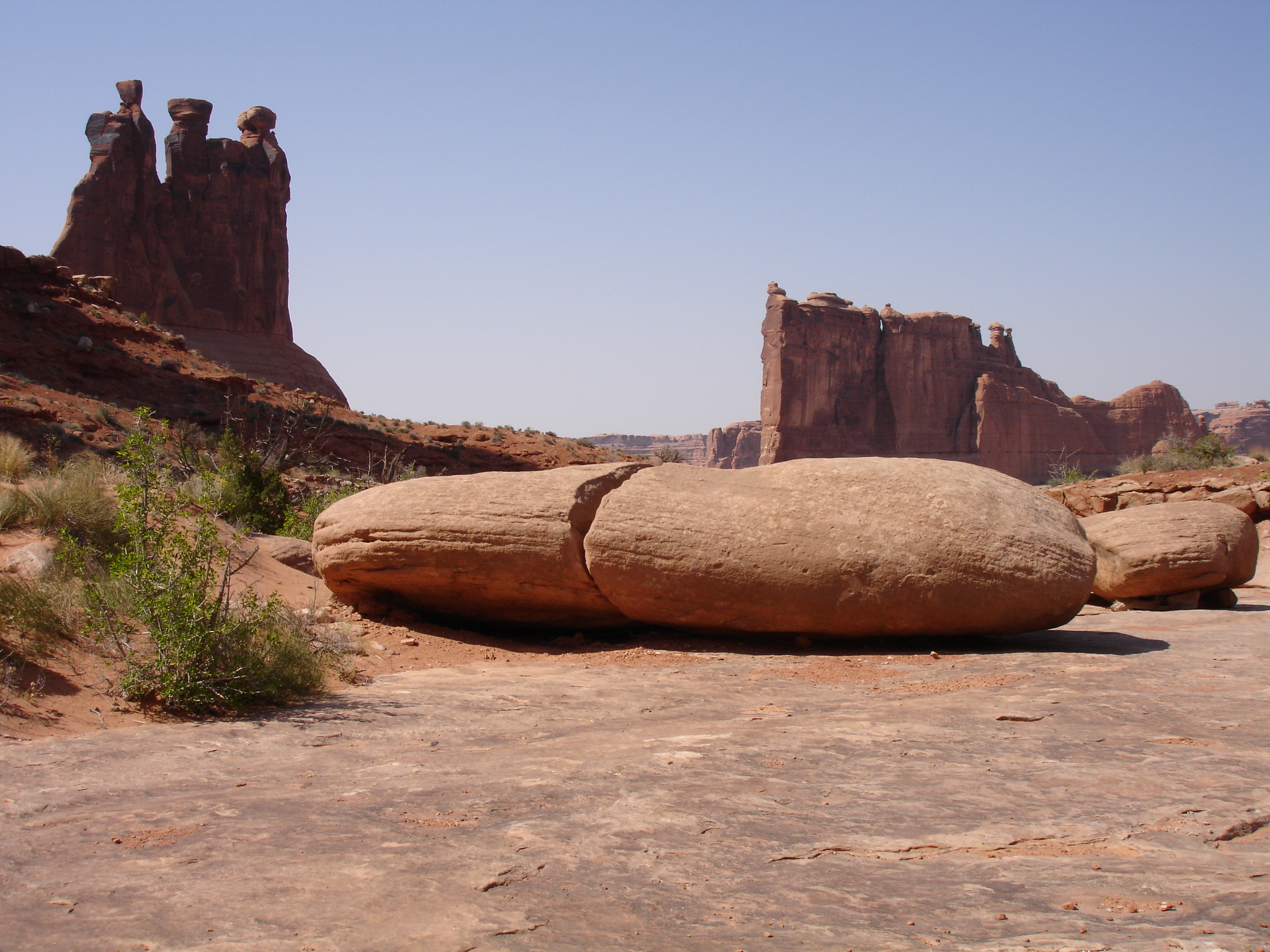
When you are coming out of the wash and the towering rock walls, the amazing Organ rock tower will come into view and opposite on the other side of the trail you will see the Three Gossips which is spectacular tower with three pinnacles on top based on a roundish pedestal that really stands out. Both are a part of the Courthouse Towers together with the Argon Tower, Tower of Babel and Sheep Rock. Again, don’t forget to look at where you came from and you will see the area from a different angle.
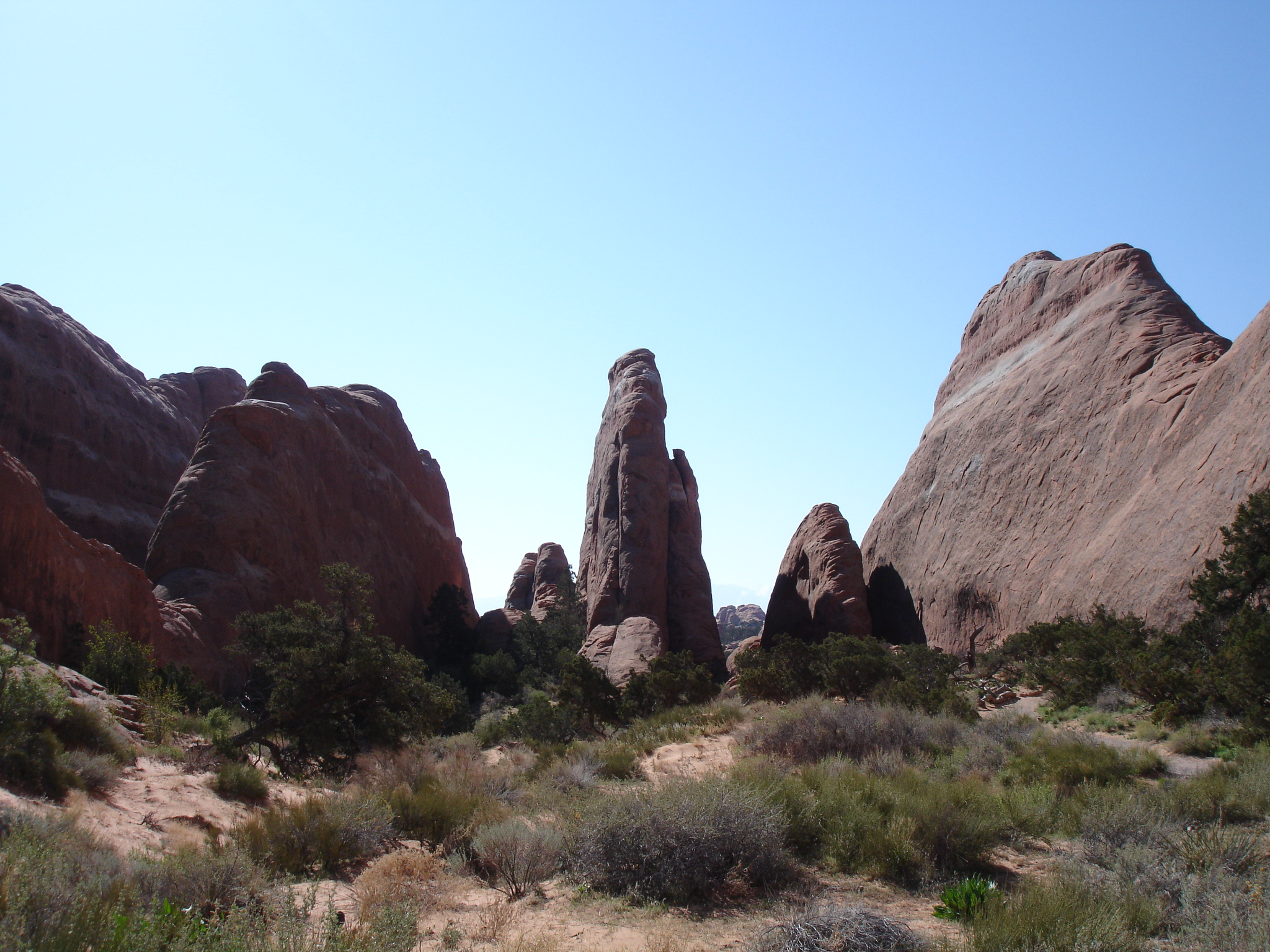
Devils Gardens
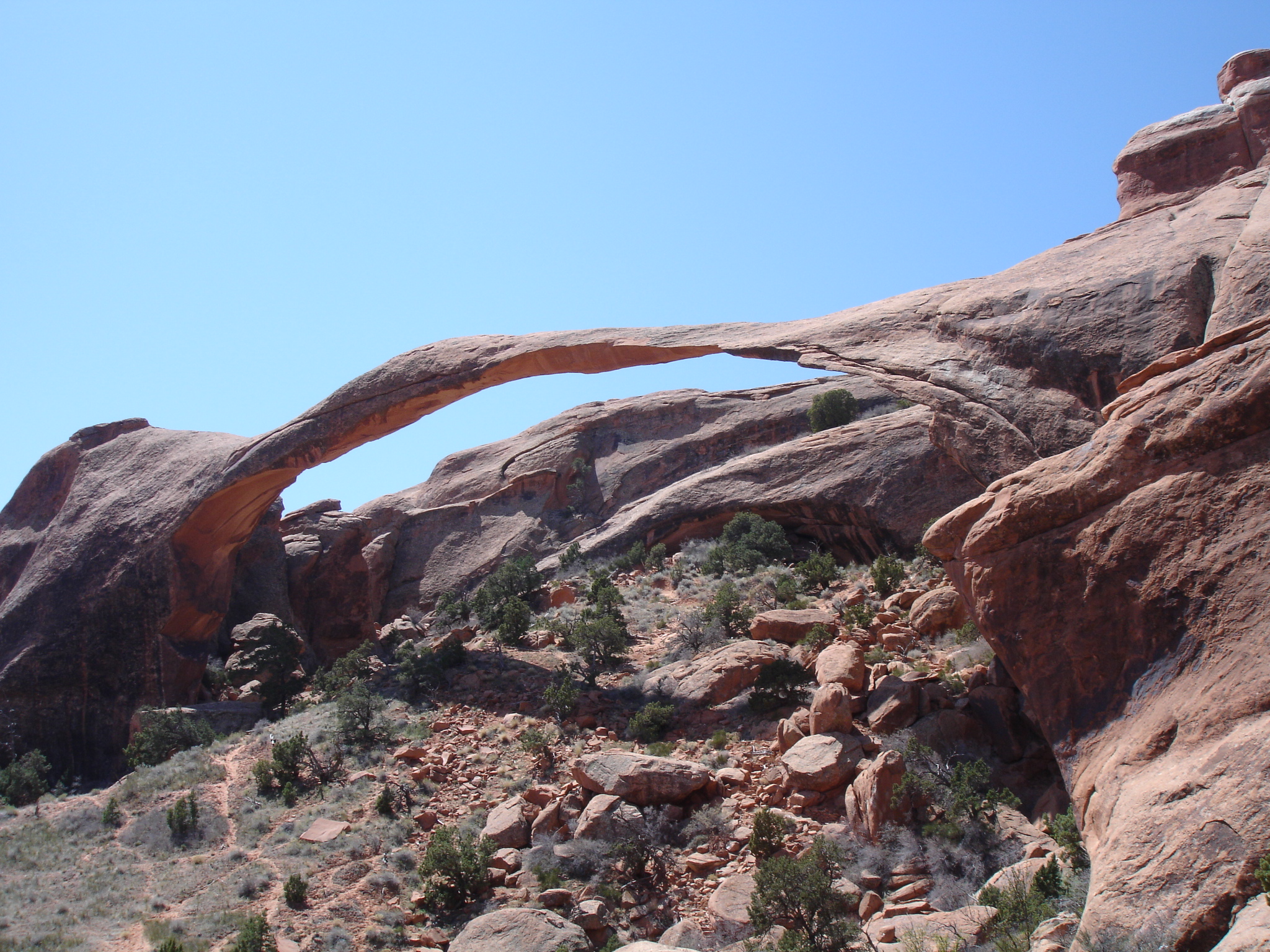
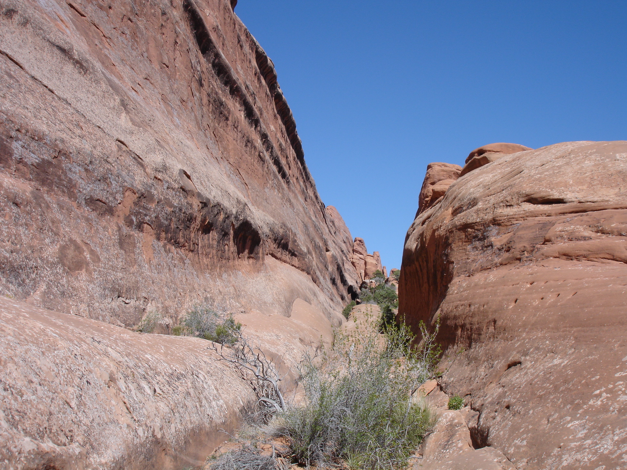
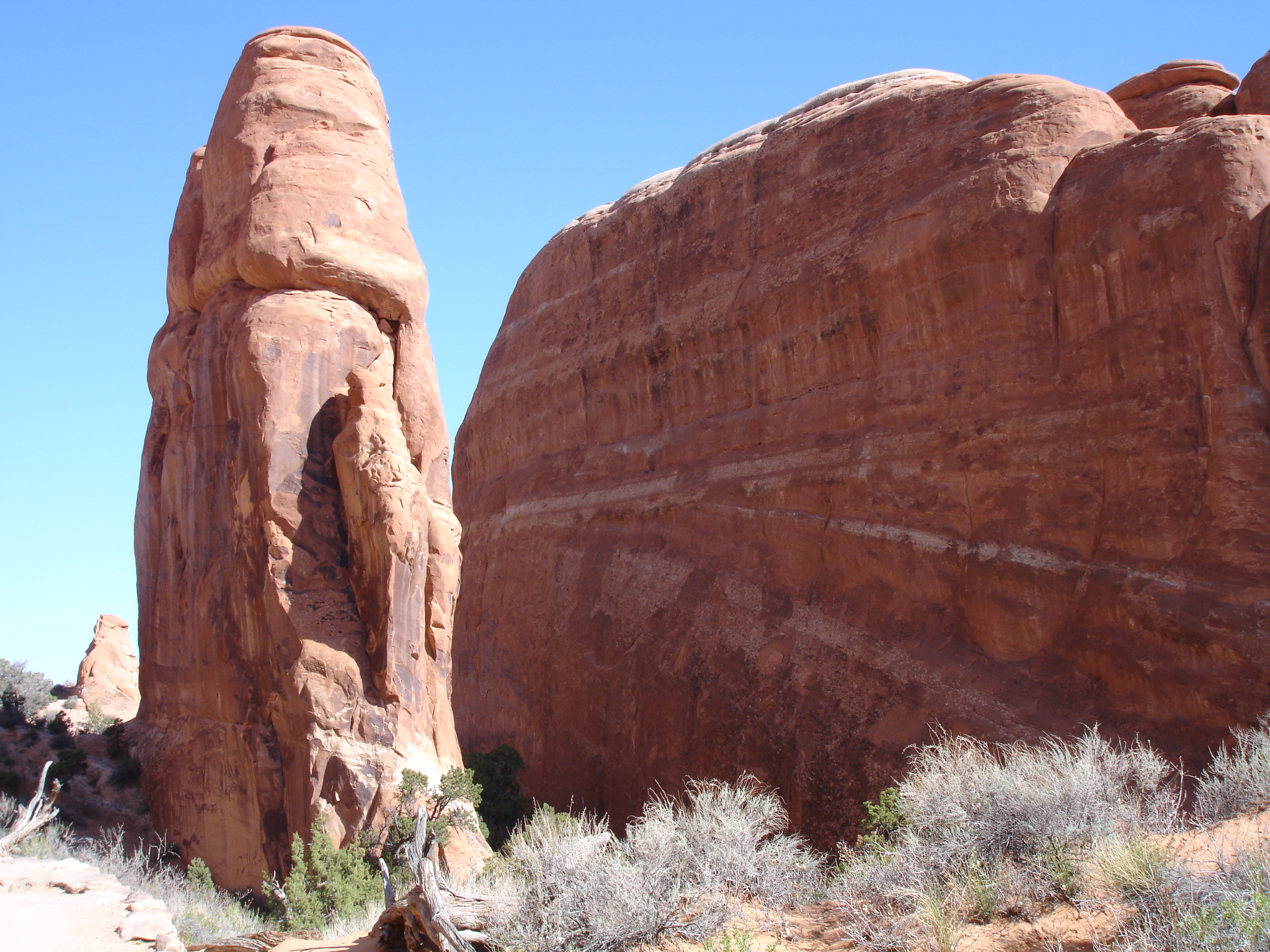
A really cool option is going on the trail out to Landscape Arch and Double O Arch. You have to go up the Devils Garden Road which is an extension of the Arches Scenic Drive. Continue up to the end of the Devils Garden Road to where the Devils Garden trail starts. This hiking trail is one of the highlights of the park. On the way to Landscape Arch and Double O Arch the trail will take you past some breath taking scenery. Right at the trailhead you will great views of beautiful rock formations such as several sandstone fins.
After you have started your hike, you will get to a point where the trail goes in two different directions. One way leads to Pine Tree Arch and Tunnel Arch, which is a short trail, and the other goes to Landscape Arch and Double O Arch. On the way to the latter you will encounter loads of amazing rock scenery on the way and other arches as well, both up close and in the distance. There will also be a bit of vegetation and small sand dunes.
The hike to Landscape Arch is not too strenuous as the trail is pretty level all the way. The distance to Landscape Arch is 1.2 km (0.75 miles) and when you get there you will have to view it from a bit of a distance as there is no path doing straight down to the arch. This is due to three slabs which have fallen down from the thinnest part of the arch since 1991 which caused the Park Service to shut down the trail that once went underneath the arch.

All the landforms are dynamic and when the first slap of the ribbon dramatically fell down in 1991 from Landscape Arch it was 18.3 metre (60 ft) long, 3.3 metres wide (11 ft) and 1.2 metres thick (4 ft). It’s the arch in the park with the longest stretch and it also considered the second longest natural arch in the world. The length is 88.4 metres (290.1 ft).
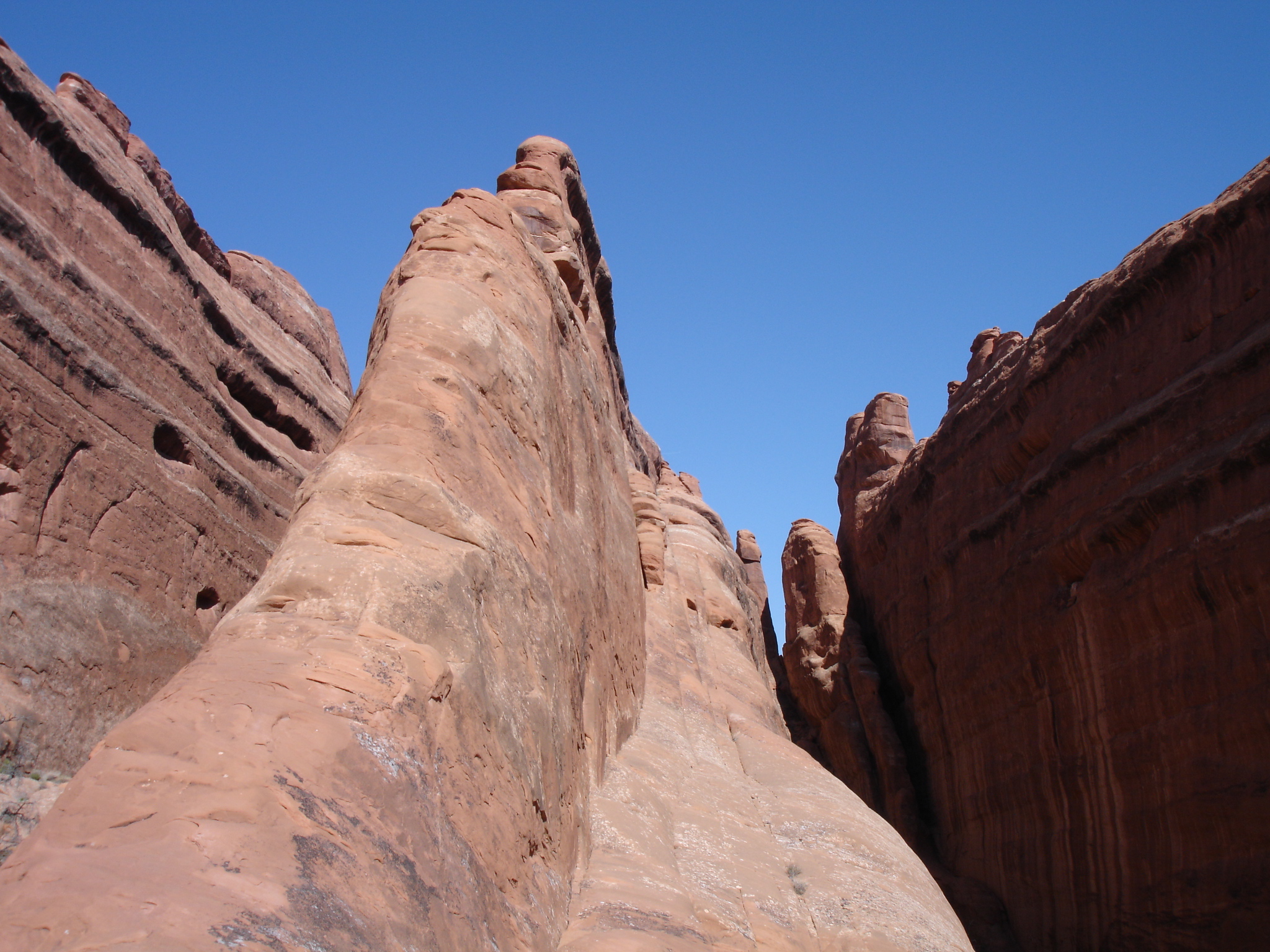
The trail after Landscape Arch will become a tad more primitive so you have to be a bit more cautious. You will experience more sand dunes, there will be interesting vegetation and you will see prickly pear cacti in the dunes as well. You will see more amazing sandstone fins, pinnacle-like formations and a wash as well. It’s so cool to hike around in this unreal landscape.
At one point down the track you have to cross some of the massive sandstone fin formations to get further on. Taking some shot in the area is highly recommended as it is a stunning view. Crossing the fins is a bit of a challenge, so it is best that you are several people to help each other. Note how the fins are separated narrow ravines.
When you get to Double O Arch you will be met by a stunning arch composed by the massive top arch and a smaller arch below it. You can get some great photos of the arch from a distance and up close or from different cool angles. Just below it to the right where you will have a great view of both arches. So awesome. You can also climb up on the big arch get a photo of yourself there or take shots through the arch of the landscape beyond it. When leaving Double O Arch you will be approached by the massive landscape of fins. An absolutely magnificent view.
A really cool thing to do after Double O Arch is continue the hike on top of one of the fins. There is a trail leading up on a fin which is wide enough to walk on. First of all it’s a really cool experience and secondly you have some killer views up here of the Devils Gardens, the fins and some arches in the distance as well. Yet another great photo opportunity of the landscape and of the fins, you are walking on and near.
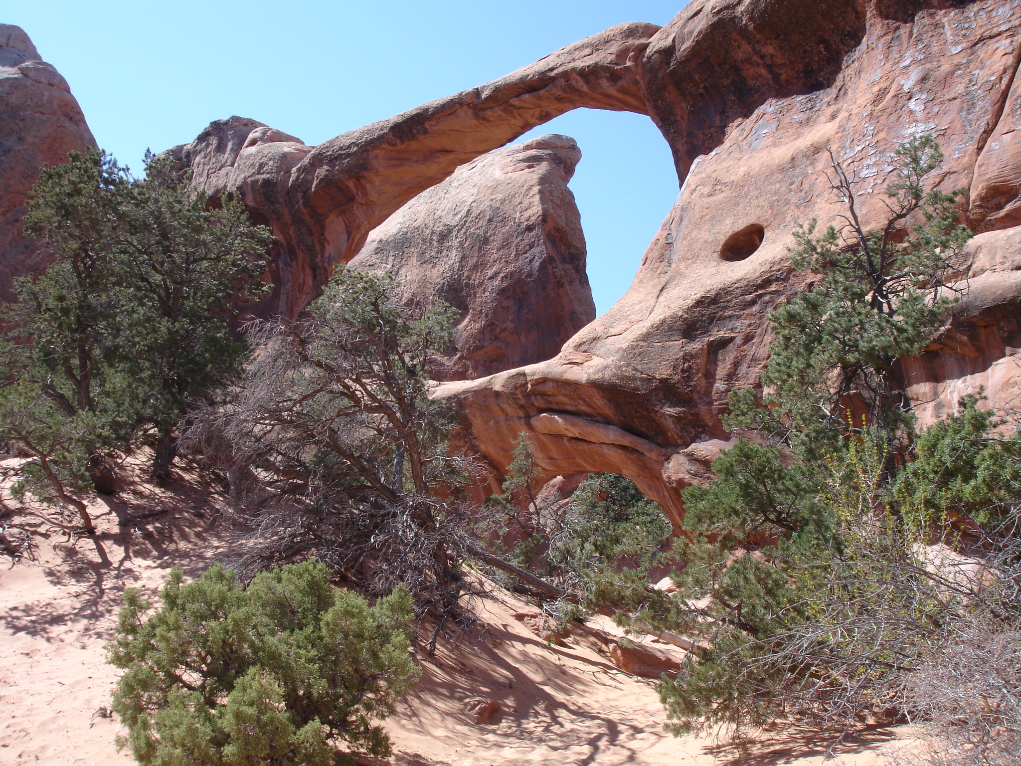
Afterwards you can continue down to Partition, Navajo and Wall Arches. Partition Arch is yet another cool formation that looks cool from all sorts of angles. Also here you can take photo onto of the main arch through to the landscape of the other side beyond Devils Gardens. There is also a smaller arch you can gaze through and take photos through.
It’s really neat to photograph the main arch up close from many different angles as you will get some really awesome motifs this way. When you get to Wall Arch you will also be a approached by a very cool arch. This one is a bit more rugged and as the name suggests it has got a massive rock wall behind it. What a great view it is. Not far from here you also be able to get an alternate view of Landscape Arch.
Delicate Arch
Delicate Arch is one of the highlights of Arches National Park which is located on the eastern corner of the park. To get there you have to drive on the Arches Scenic Drive and down Delicate Arch Road. Park at the Wolf Ranch parking area and start the hike here. The hike is a 4.8 km (3 miles) return walk and is a tad strenuous. The elevation gain is 146 metres (480 ft). On the way you will have get views of the La Sal Mountains, rock formations and arches.
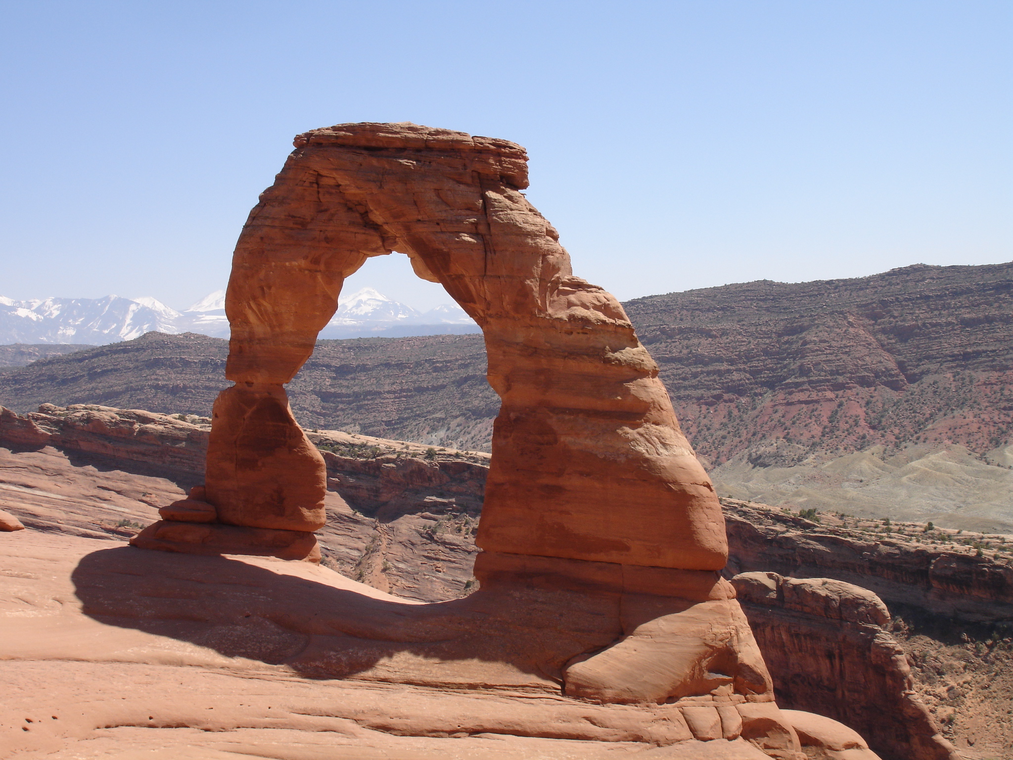
The first part of the trail is up a wide area and once you reach slick rock and then rock cairns, the trail gets steeper and then levels out on top of the rock face. Then you have to go around a rock ledge for about 180 metres (591 ft) and you will then be absolutely stunned by the view of the massive standalone arch called Delicate Arch. This is probably the most widely known landmark of Arches National Park.
Delicate Arch is 20 metres (65 ft) tall and is formed by Entrada Sandstone and is freestanding on a large rocky and fairly level surface. It’s an isolated remnant of a bygone fin standing on the edge of a canyon. Absolutely fascinating and probably one of the most amazing landmarks in the United States.

Take your time up here. You can easily spend about two to three hours doing this hike. So you can spend time walking around the area checking out the scenery. You will have the arch with the La Sal Mountains as the backdrop. You can also walk up to the arch and have so close up photos from many different angles. Just bear in mind that you don’t spend too much time right at the arch. Think about your fellow travellers and the many other visitors who would like to have a photo of the arch with no people in it. Do not sit on the arch for a long period of time. It is very inconsiderate to other people.