Breathtaking & Majestic Scenery
Auyuittuq National Park is an absolutely stunning nature preserve in a remote region of Artic Canada…Its beauty will leave you mesmerised
The Park is based on the Cumberland Peninsula in the south-eastern part of Baffin Island in Nunavut, northern Canada. It comprises an area of 19,707 square km and it is absolutely amazing. It’s probably one of the most beautiful spots you will ever see, so paying it a visit is highly recommended.
The name Auyuittuq is Inuktitut which is the Inuit language of the region. It means “the land that never melts” and is pronounced “Ow-you-ee-toock”. It was established as a national park reserve in 1976 and became Auyuittuq National Park in 1999 with the creation of the Territory of Nunavut.
Akshayuk Pass is 96 km (60 miles) long and cuts right through the peninsula. This is the most spectacular area of the park to explore and also the easiest to access. Besides having emergency shelters at eight sights along the way, the route is completely isolated and undeveloped which makes it so cool. You really get the feeling of being in the untouched wilderness.
Geology: The Formation of the Stunning Landscape
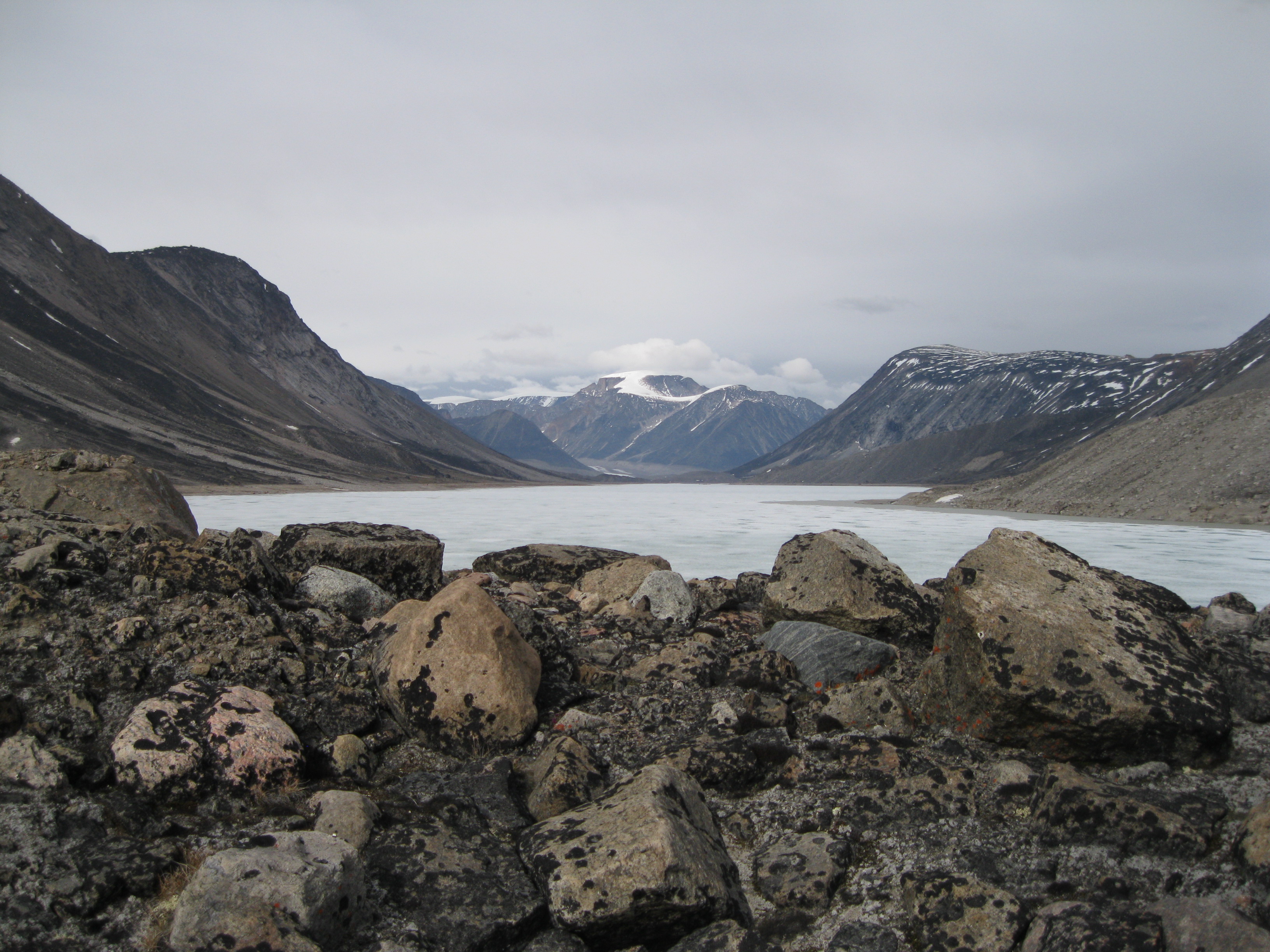
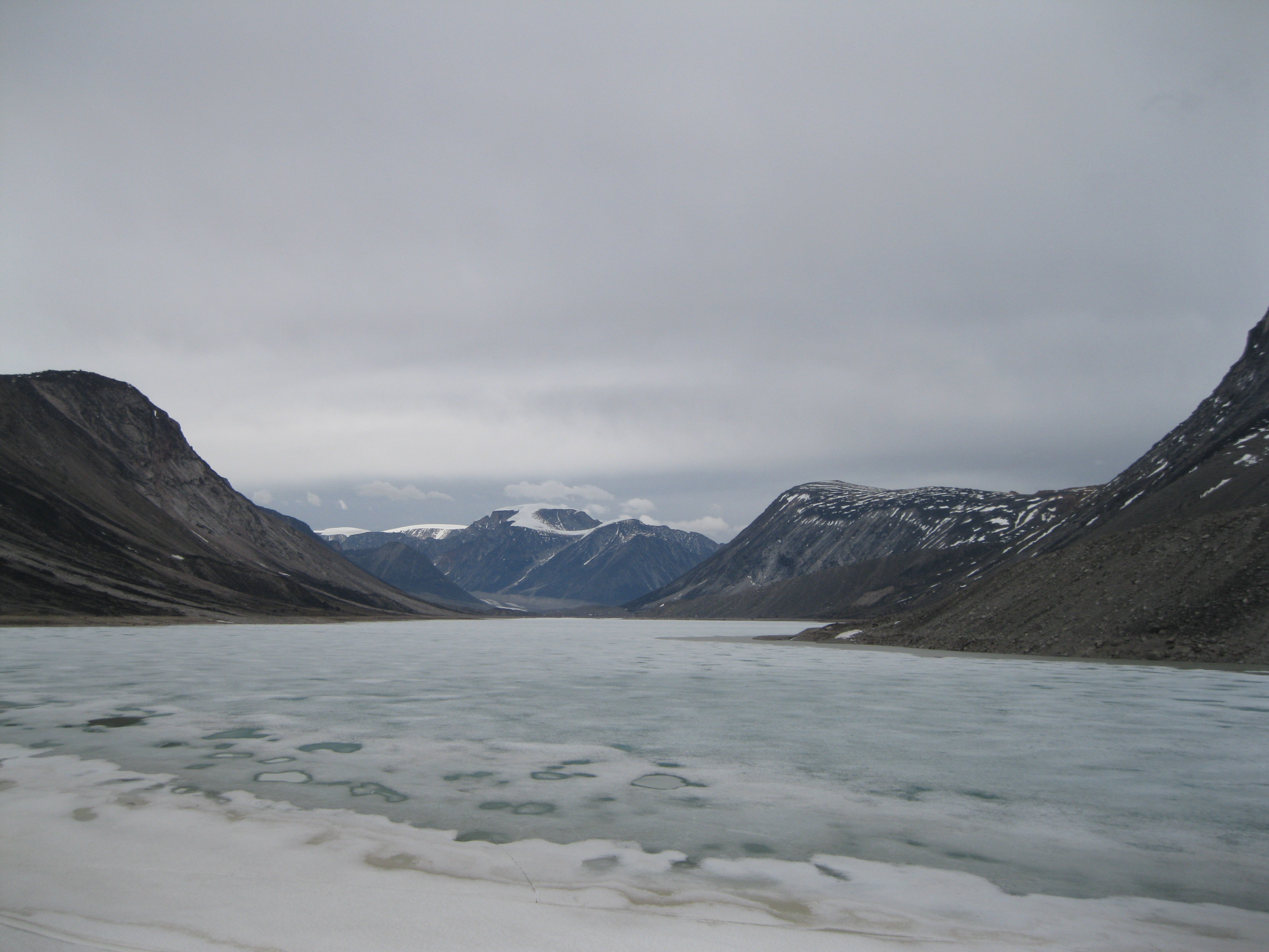
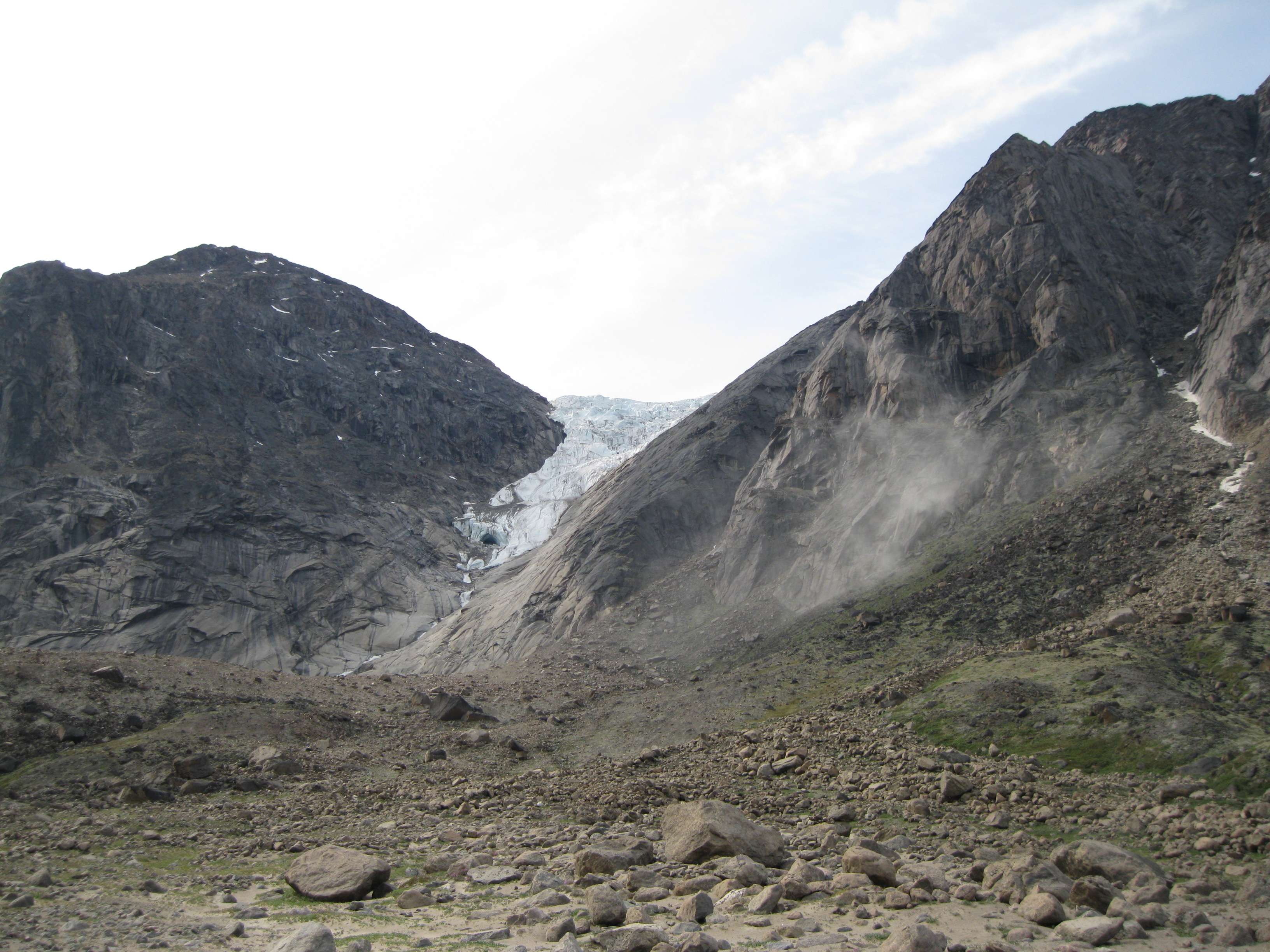
The Penny Ice Cap covers 6,000 square km of the park area, is 300 metres deep and is the size of Prince Edward Island. This ice cap is a part is the southern-most remnant of the Laurentide Ice Sheet which covered most of North America east of the Rocky Mountains 18,000 years ago. The Penny Ice Cap is based beyond Akshayuk Pass but its influence is clear all the way through the pass as you will see many glaciers, moraines, rivers and the fjord as a result of its presence.
Baffin Island forms the north-eastern edge of the Canadian Shield. The landscape was created during the Precambrian era, which is the oldest period of geological time, going back 570 million to 3.5 billion years ago
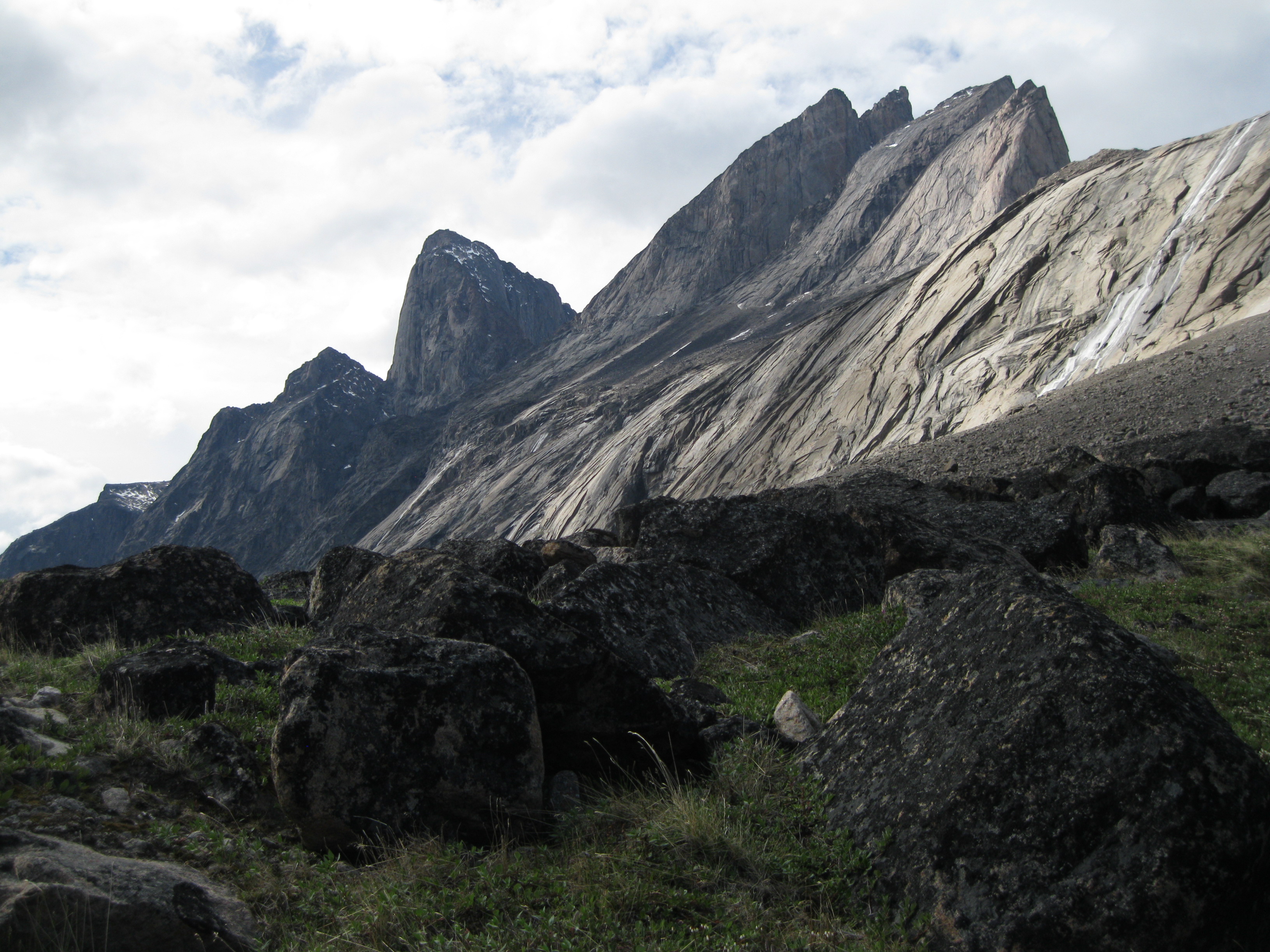
Ice flows around gneissic mountains were created more than two billion years ago during a very slow collision of the Earth’s continental plates. Gneiss is a foliated metamorphic rock and foliation is the repetitive layering in the rock. In spite of ages of metamorphosis, which is alteration by intense heat and pressure, and faulting, intrusions and erosion from glaciers, plus rain and frost weathering, the mountains still reach 2,000 metres (6,562 feet) above sea level. The result of the metamorphism was granite. The oldest rocks in Auyuittuq National Park and the Cumberland Peninsula region were formed about 2.8 million years ago and metamorphosed into granite 2.5 million years ago.
About 550 million years ago, early in the Paleozoic era, lifeforms were spreading across the Earth. At this time the eastern Arctic was covered by a shallow sea and a deposit of thick layers of marine sediments over bedrock. Around 60 million years ago a major upheaval took place which separated Baffin Island from Greenland. The Cumberland Peninsula was uplifted and following erosion removed the sediments and exposed bare rock yet again. The mountain peaks in the park are the tallest on Baffin Island and in the Canadian Shield.
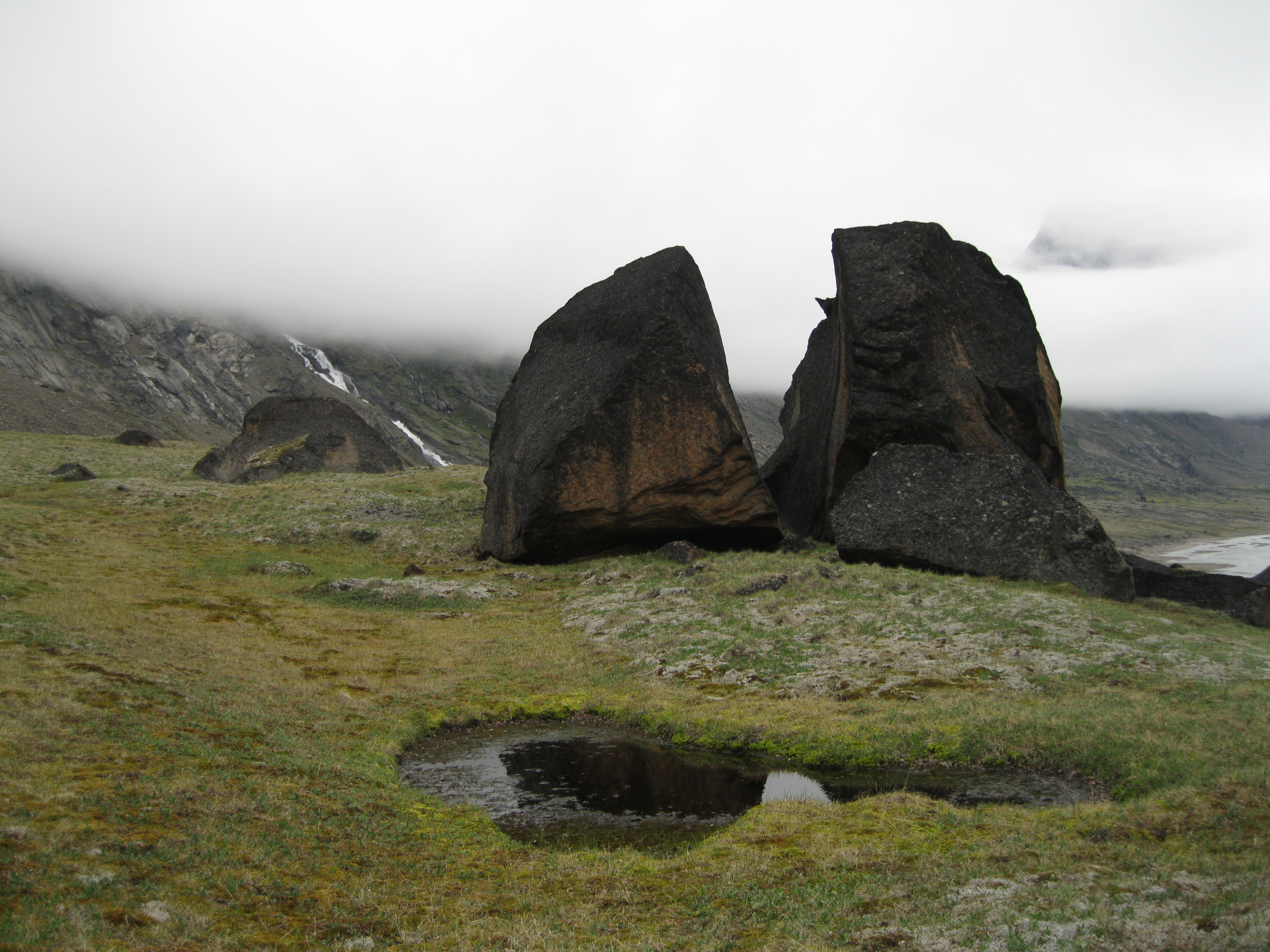
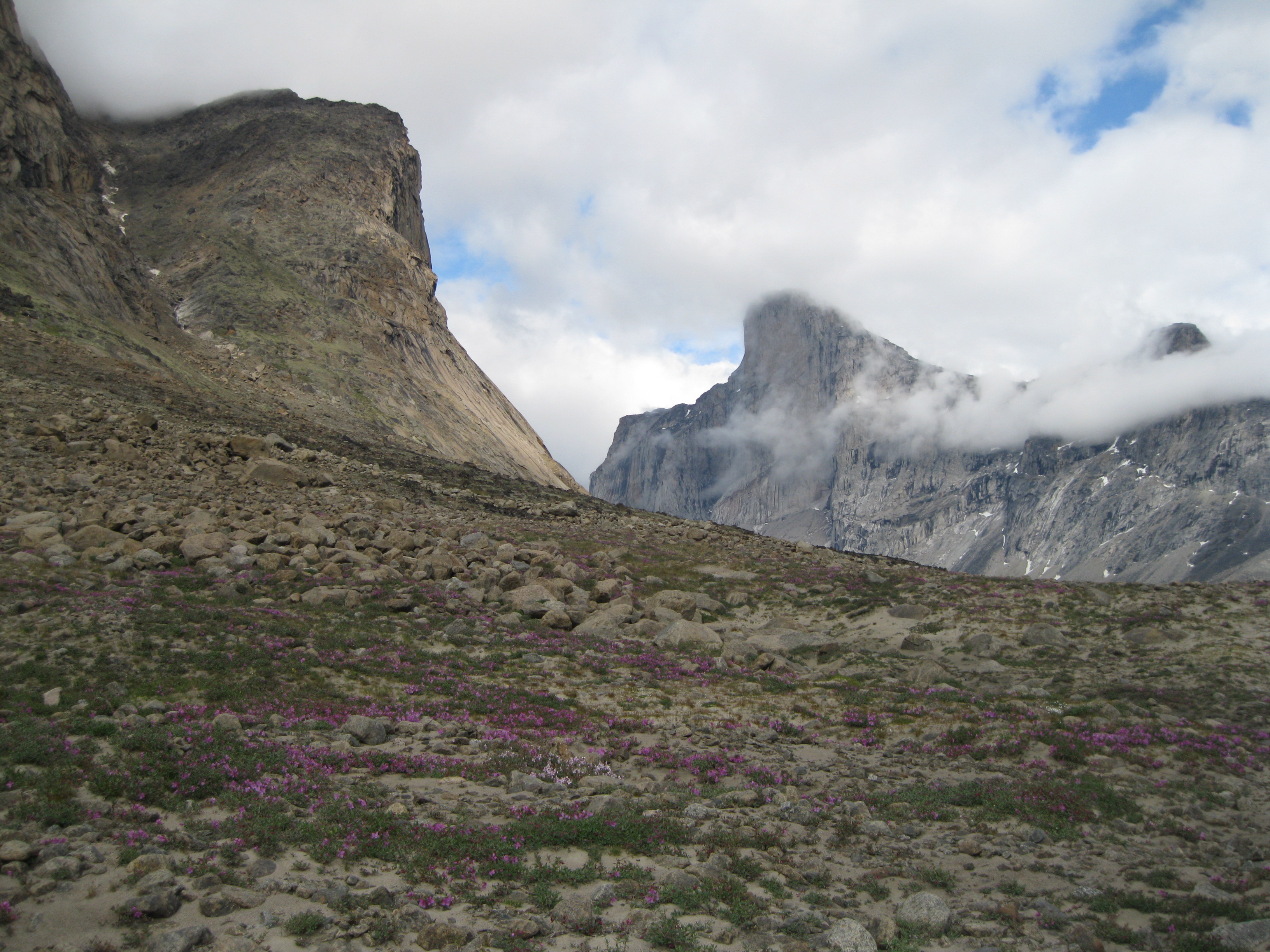
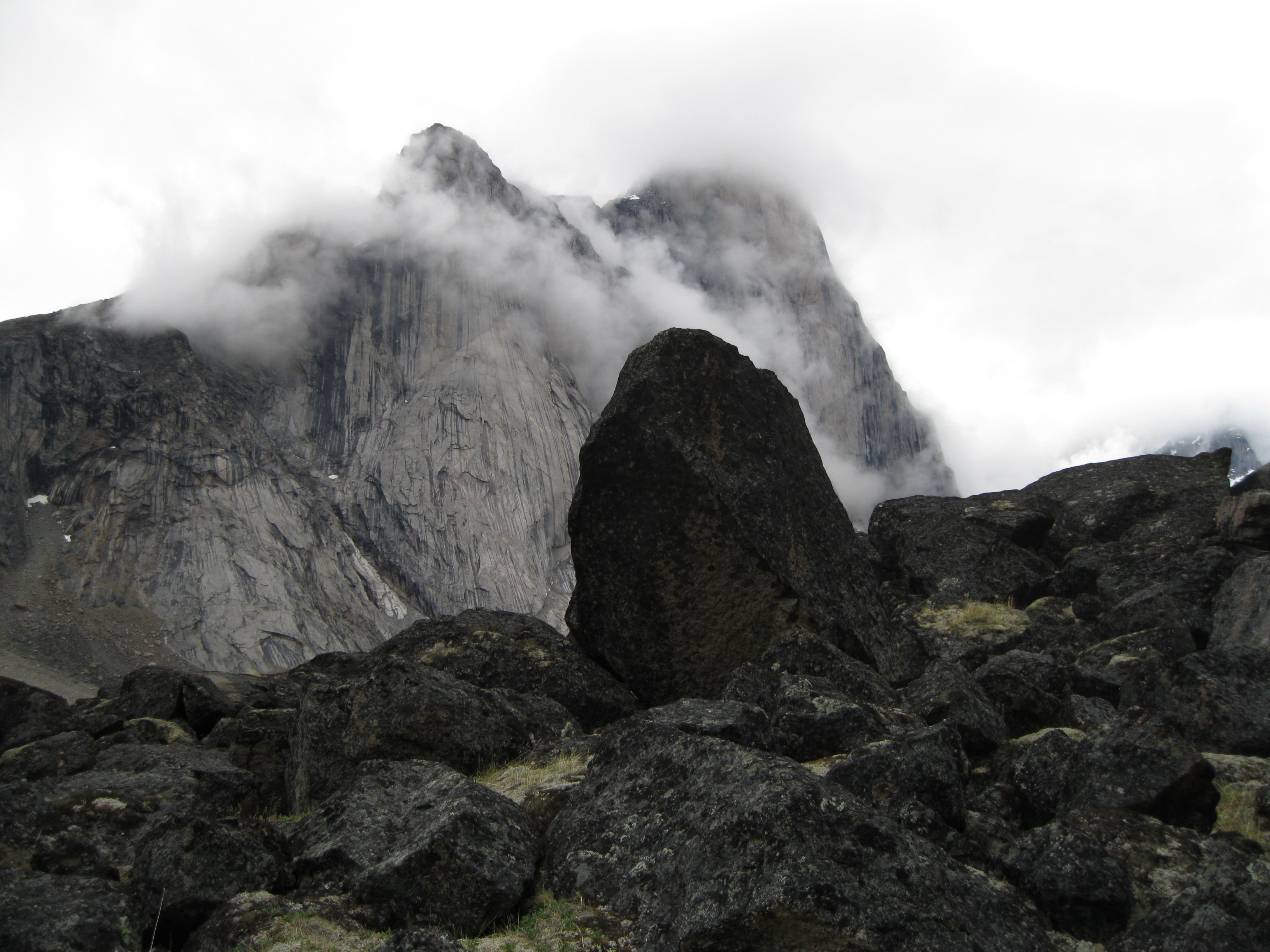
The scenery of the park, the valleys and the massive granite peaks, were formed by more recent erosion and glacial activity. It is the most geologically dynamic national park in Nunavut which landscape is 85% rock and ice. All through the park you will see the effects of changes in geology and the influence of ice, wind and water. Glacial features you will see in the park are moraines, cirques, sand deposits, perched boulders and scree slopes.
The Wildlife
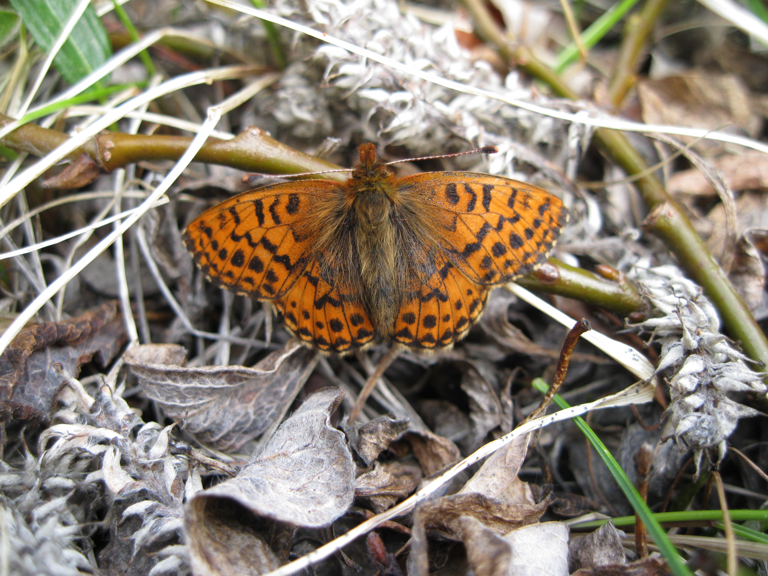
There is a bit of wildlife in the park but don’t expect to see a lot of it. You have to be bear aware to a certain extend but polar bears are rarely seen. You will most likely spot a couple of arctic hares. They are very timid and jump away fast so you have to be quick with your camera to get a decent shot. There aren’t many birds but you will most likely see a couple of snow buntings or geese here and there. If you are very lucky you may even see butterflies such as the arctic fritillary.
There are fewer animals in the arctic, as opposed to the south of Canada, but there are often a higher number of individuals within a species. Many of the arctic animals migrate which gives them great opportunities to find good calving or nesting spots. Only 15% of the park is suitable for wildlife habitat due to the rest being covered by mountains or ice.
There are 18 known species of breeding birds in the park. The most common land birds are the rock ptarmigan, Lapland longspur, snow bunting and water pipit. Common freshwater birds of the park are the red-throated loon, Canada goose and snow goose.
Eight species of terrestrial mammals and six species of marine mammals are found in the park. The most common terrestrial mammals are the arctic hare, arctic fox, ermine and the brown lemming. It’s pretty unlikely that you will see any marine mammals especially if you are in the park during summer. Polar bears, seals and whales have been seen in the park.
The Fascinating Vegetation
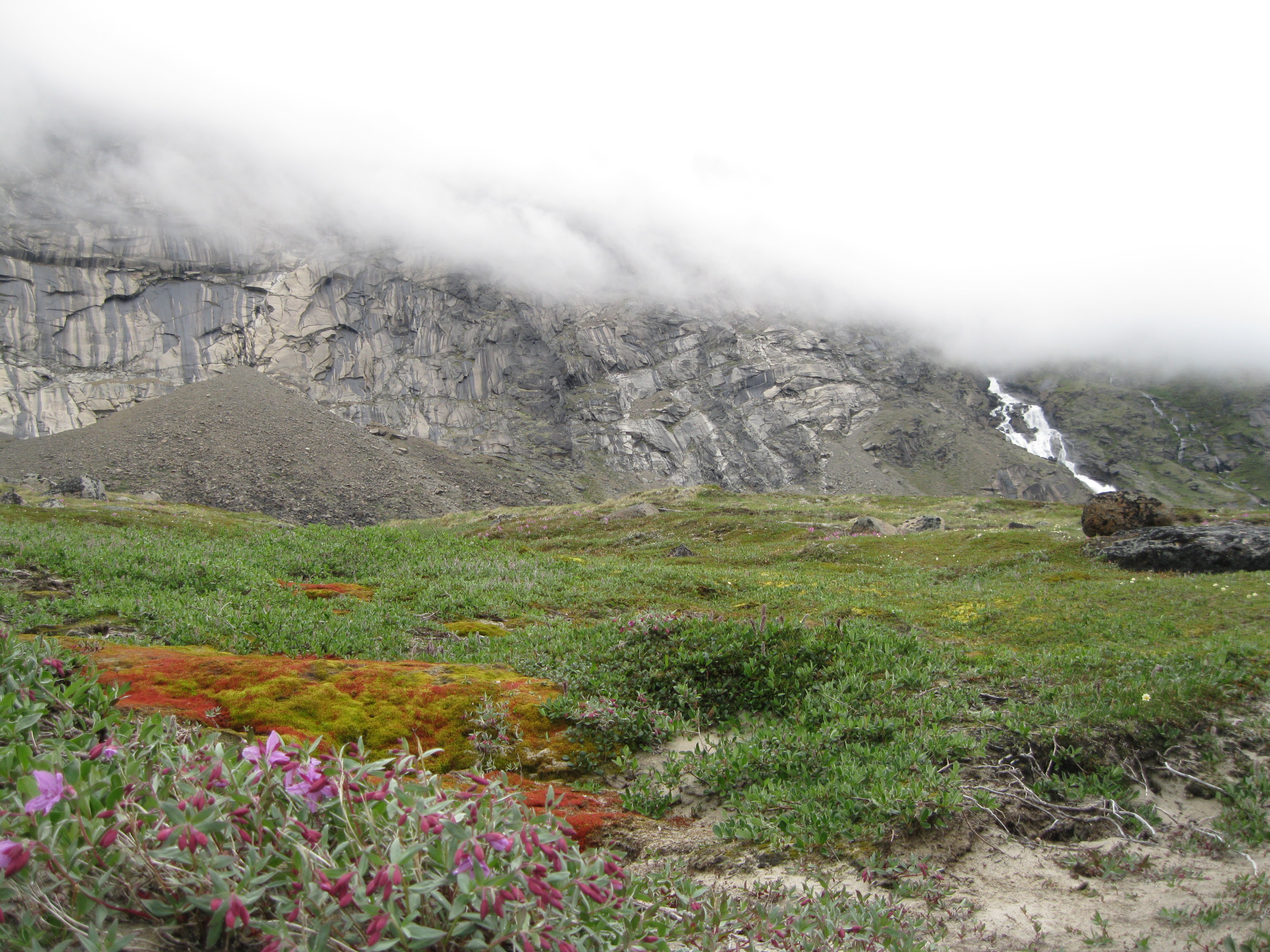
Vegetation can only survive in the artic environment when it is undisturbed for a period of time. The strong winds, short growing season, freezing temperatures, permafrost and the low nutrition of the soil makes life difficult for the plants and organisms. Since the park is dominated by rock and ice it limits the diversity and distribution of plants. The valley and the lower slopes of the pass are mainly ice free, so they provide a stable environment for lichens, grasses, mosses, flowers and shrubs. Only 15% of the park is covered by vegetation and more of it is based in the valley and on lower slopes less than 500 metres (1,640 feet) above sea level.
There have been documented 112 species of vascular plants, 97 species of lichen and 136 species of bryophytes/mosses.
It’s really fascinating how the artic plants have adapted to the harsh environment. Some plants preserve the heat by crowing in rosettes or compact mats. Others have hairy stems or woolly seed covers. The plants are small and grow close to the ground.
Most arctic plants contain different degrees of a compound known as pigment anthocyanin which absorbs solar radiation and allows photosynthesis to happen at lower temperatures than normal. In areas where the vegetation is thick, the ground level temperature may be 20 degrees Celsius (68 degrees Fahrenheit) higher than the air temperature because the heat absorbing powers of anthocyanin. Dark colours plants attract more heat than the light coloured plants, and the latter will compensate for this with their contents of anthocyanin.
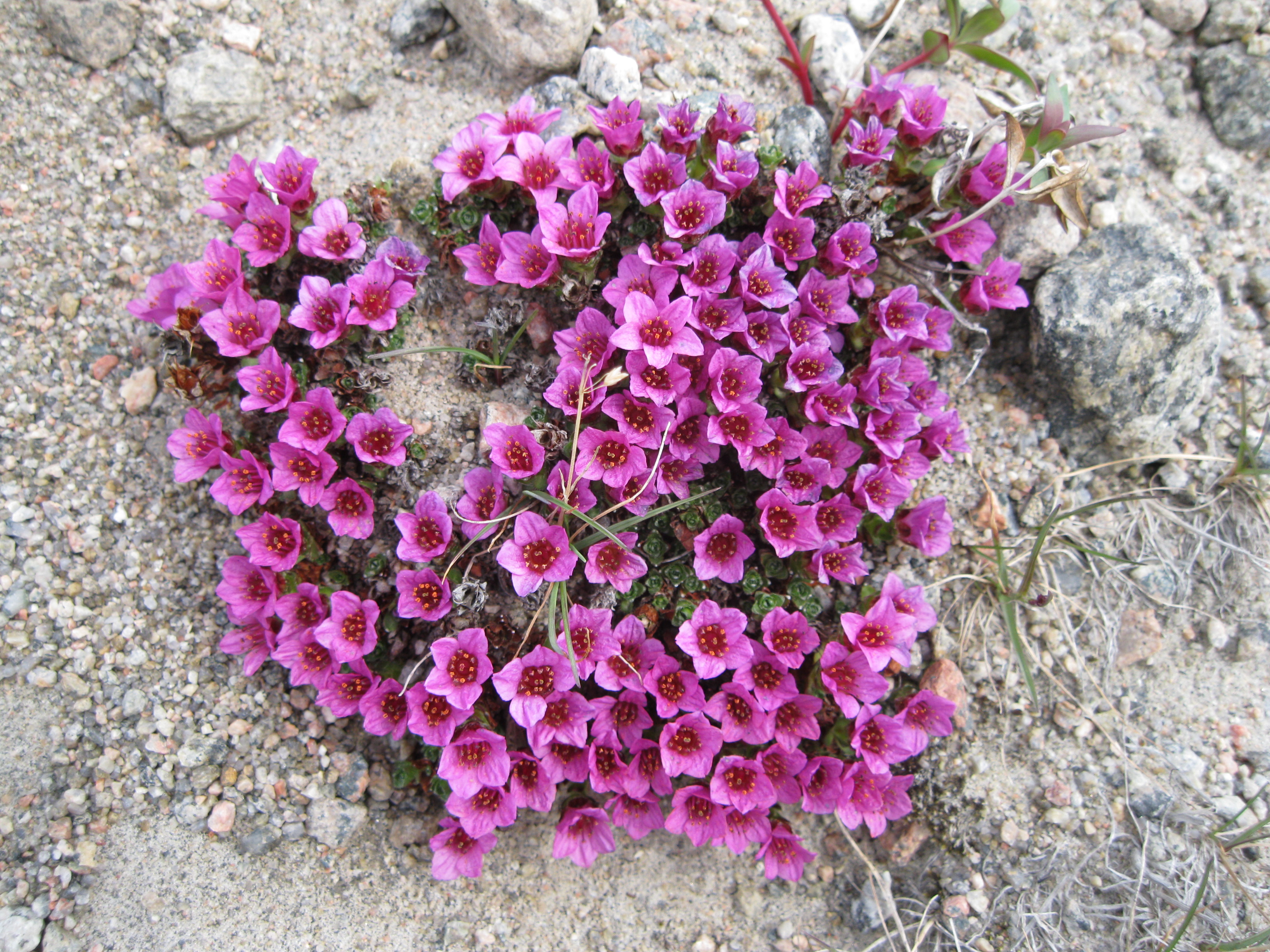
The Beautiful Arctic Flowers
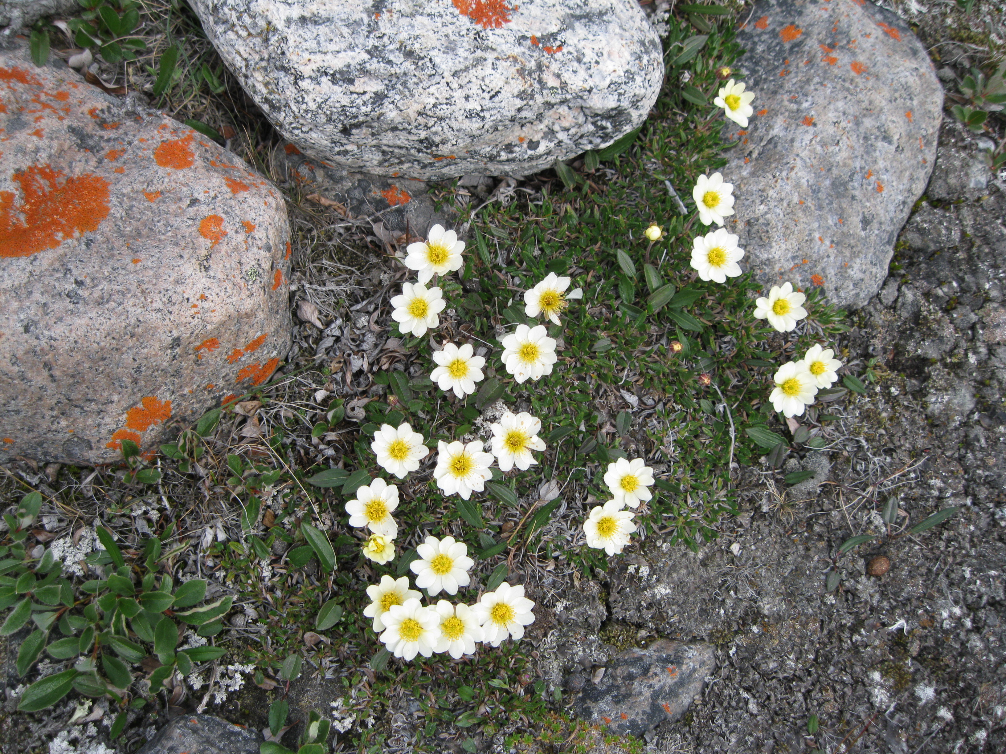
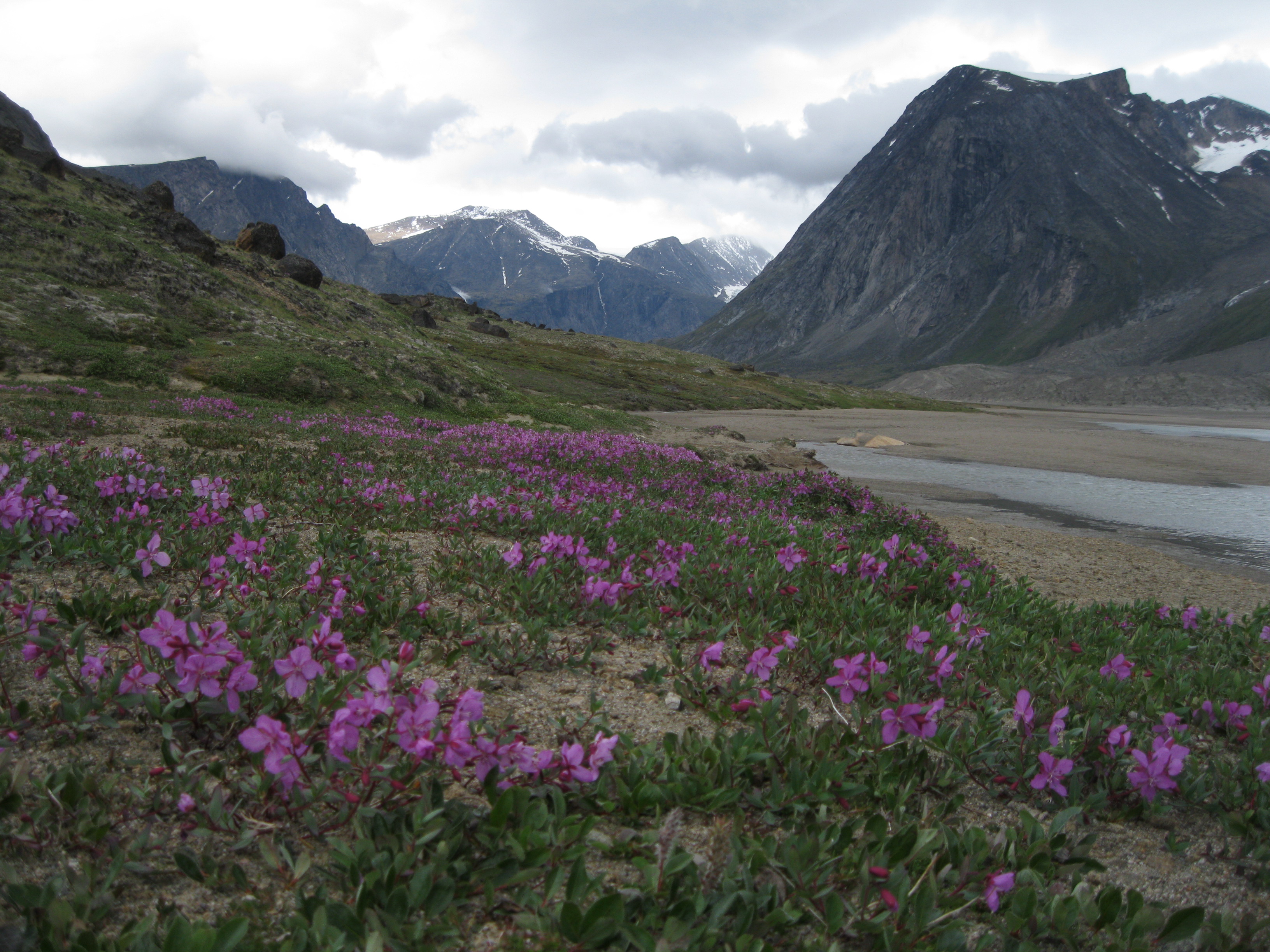
There are many beautiful artic flowers in Auyuittuq National Park which are mostly predominant in late June, July and early August. Some of the species present are the dwarf fireweed, mountain aven, large flowered wintergreen, northern willow, saltmarsh starwort, arctic bladder campion, moss campion, arctic poppy, arctic mouse-ear chickweed and prickly saxifrage. You will be surprised to see dandelions here and there as well. In higher elevated areas you will also see the purple saxifrage which is a really pretty flower. So get ready for a beautiful and colourful display of wildflowers across the tundra.
The most tundra plants are perennials which means they live for more than two years. They are able to survive the permafrost with their hardy root systems. Year after year they the thaw out and come back to life, which means they warm up from being frozen during winter.
One of the most present flowers is the dwarf fireweed which gives the scenery a really beautiful purple presence in certain areas. It’s a part of the evening primrose family and has the largest flowers of any plant in the Canadian Arctic. It has several flowers per stem and petals as large as three centimetres (1.18 inches). They grow in clumps which creates a microclimate slightly hotter than the surrounding environment. As mentioned earlier, this allows photosynthesis and other plants to function more easily.
The dwarf fireweed is mainly found in moist, sandy and well-drained soils along shores, river banks and flood plains. Even though tundra soils are shallow, acidic and low in nitrogen, the plant is aggressive and spreads through out disturbed areas as they produce small and light seeds which are only two millimetres long and are easily carried by the wind, allowing the plant to colonise.
History: The European Explorers & the Whalers
In 1583 English navigator John Davis suggested to the secretary of Queen Elizabeth I, Francis Walsingham, that a voyage to search for the Northwest Passage would be a good idea. By 1585, the secretary authorised and funded the expedition. They went via the route of seaman Martin Frobisher, who had already been on three expeditions to the Northwest Passage. Davis was the first European to explore the Cumberland Peninsula region. According to the expedition reports, they did not encounter any humans but they did see evidence of human habitation.
Another English navigator, William Baffin, was employed as a pilot on the ship Discovery under the command of Richard Bylot, and set sail towards the Northwest Passage in 1616. Baffin didn’t realised that Lancaster Sound, which he named after the sponsors of the trip, provided an opening into the strait he was searching for. He did chart and name the main features of Baffin Bay.
Baffin’s voyage lead to an increasing number of European whalers between Baffin Island and Greenland. The first recorded contact between the Europeans and the Inuit was when Scottish captain William Penny entered Cumberland Sound in 1839 and he established a whaling station on Kekerten Island in 1840. With the appearance of European and also American whalers in 1852, the Inuit culture changed. Seasonal hunting continued, but patterns changed to fit in with the whaling season as many Inuit were employed by the whalers. The whaling stations also became a focal point for availability and distribution of European goods.
By the early 1900’s whaling was no longer profitable and the Inuit moved inland to find food and work. They started to trade fur. A trading post was established in Pangnirtung in 1921 by the Hudson Bay Company which was followed by the opening of an office for the Royal Canadian Mounted Police in 1923.
Once a year a Hudson Bay Company supply ship would enter the area to pick up fur and whale oil, and drop off food supplies, cloth, guns and other tools. Sometimes the fjord would be all iced up preventing the supply ship to enter. That would make it two years between the arrival of supplies. It would make life lonely for the staff of the Hudson Bay Company and the Royal Canadian Mounted Police with only yearly visit from the outside.
Flying Into Baffin Island
As the park is located in the Arctic, flights going in and out of the area are pretty unpredictable. You have to fly into either Pangnirtung or Qikiqtarjuag to access the park. Most visitors go to Pangnirtung, nicknamed Pang, which is what locals and most people call it. There are no direct flights from any major Canadian cities to Pang, so you have to fly to Iqaluit and connect to Pang from here.
Iqaluit is the hub for all air travel going into the eastern Arctic. As the flights are unpredictable you may be stranded in Iqaluit for a day or so, just bear this in mind. Flights may be cancelled and this is mostly due to weather conditions in Pang. It can be because of crosswinds or fog. Mind you, Pangnirturng Airport is small and the planes flying in and out are small as well so they are more sensitive to strong winds.
Furthermore, the flights to Baffin Island are very expensive. If you are flying from southern Canada you can fly in from Ottawa or Montreal. Flying from southern Canada to Pang can be more expensive than flying from northern Europe to Sydney in Australia. You just have to be aware that when planning your trip, that flights to Arctic Canada are crazy expensive.
So you may end up having to spend an unplanned night in Iqaluit. The hotel rates are outrageously expensive, so the damage for a single room will be around 220-265 CAD including sales tax. Note at the hotel they will quote you the rate excluding tax, so when you initially think it is crazy expensive, prepare yourself for another shock when you realise you have to add the sales tax (VAT/GST) on top.
Spending a day or evening in Iqaluit is a bit of an experience so if you are doing that it is not wasted time. You will get to see an Arctic Canadian town and the capital of Nunavut. The architecture is rustic and not very scenic. It’s the typical style of Arctic towns but that is a really cool thing to experience as well. Have a stroll around town, check out the buzz and take some photos. There are a couple of supermarkets you can visit and you can also go down to the shoreline where you will see the surrounding mountains and the ice on the ocean if it has not melted away yet. You can get some neat shot here.
Visiting Pang is quite the experience as well. As mentioned earlier, the airport is very small, only has one gate and there is no security check. As you arrive you will see the amazing mountains surrounding the hamlet and in the distance the Pangnirtung Fjord will come into view. A fantastic view. Have a stroll around the hamlet. It’s a pretty cool to experience such a remote arctic settlement. Most of the inhabitants are Inuits and the architecture is the common style for this region.
Before Going to Auyuittuq National Park
If you are going to Auyuittuq National Park for a hiking or backpacking trip you can go from the last week of June from the Pang and from late July from Qikiqtarjuaq all the way till late September. During spring you can go on ski and glacier expeditions. Mid-March till late April is the season for ice cap travel. For most of May and June the park is inaccessible due to the soft ice which makes it too dangerous to enter.
Make sure you are fully prepared when you head off to the park. Bring sufficient clothes, food and gear. This obviously depends on when and what kind of trip you’re doing. If you are on an organised guided tour, things such as food, cooking equipment and tents are probably provided for you. If you are going by yourself remember that you have to be self-sufficient. Therefore bring stoves, cutlery, food and extra food in case you are stuck for some additional days. Furthermore bring enough layers of clothes as well. Bring what is suited for you and don’t overpack as you will be carrying everything yourself.
So again, have enough layers, try not to pack too many undies and socks. People tend to overpack on toiletries as well. Don’t do that. Even though you may be in the park for 13-15 days without washing yourself and having a shower, you will be surprised how little you stink, if you even smell bad at all. Also, you are all in the same boat when it comes to B.O. and there is no-one to impress anyway. Therefore if you are going for a couple of weeks in July, don’t bring more than the pants and the t-shirt you are wearing, an extra t-shirt, 3-4 pairs of undies and 3-4 pairs of hiking socks. The amount of additional layers such as long undies and tops you bring really depend on how easily cold you normally get.
If you are going in July the temperature will be around 5-15 degrees Celsius (41-59 degrees Fahrenheit). You have to prepare to a lot of wind, rain and sunshine. So you definitely have to bring things like a cap, a beanie/tuque, sunglasses, sunblock and rain clothing.
If you are planning your own itinerary you have to be aware of the ever changing weather. Leave in extra time and days for the unexpected. The water levels may raise due to glacier melt water or rain so you may not be able to cross some streams when you want to. Therefore you may have to wait until the level drops.
Before going to Auyuittuq National Park you have to visit the Parks Canada office in Pang to fill in some required forms. Furthermore you will get a briefing on safety in the park with regard to polar bears, other wildlife, hiking and river crossings.
This will be following by a video on polar bear safety. Polar bears have been seen in the park but are pretty rare. So you don’t have to fear an encounter but somebody in group should definitely bring bear spray. Also especially if you are travelling by yourself. Better safe than sorry. Grizzly and black bears are not found in this part of Canada. If you are organising the trip yourself please make sure to pre-book this orientation meeting with the park staff. If you are on an organised guided tour, this will have been booked for you as a part of the trip.
Visiting Auyuittuq National Park
To get from Pang to Auyuittuq National Park you have to book a boat ride through the beautiful Pangnitung Fjord which will take an hour and covers a distance of 32 km (20 miles). To make the transfer possible, the tide has to be high in Pangnirtung Fjord. The trip on the boat is a cool experience in itself. You will have some great views of the fjord, the surrounding mountains and Pang as well. There is plenty of time to take it all in.
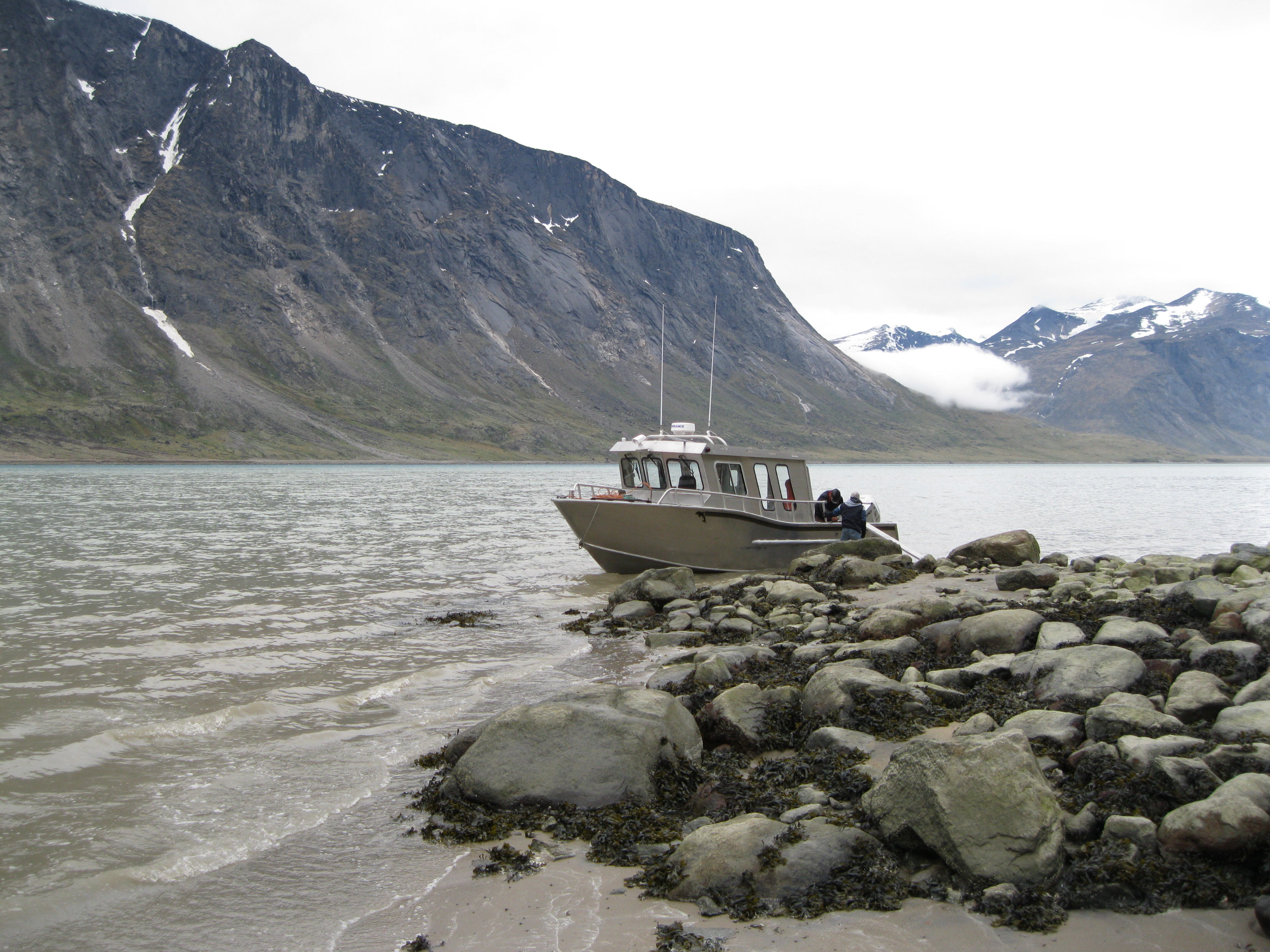
It’s a small boat, but you can sit inside if you feel it’s too cold and windy or you can stand outside where you will have the best view and you can take some great shots as well. Getting a great photos on the way is a bit of a challenge as it’s a fast and slightly bumpy ride, but it is definitely possible.
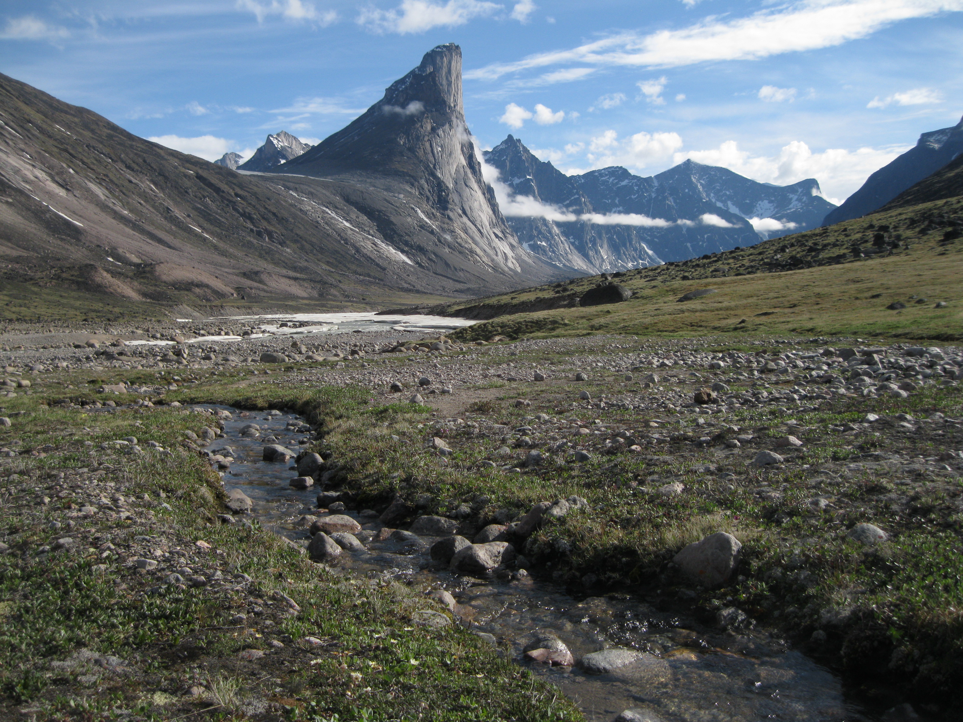
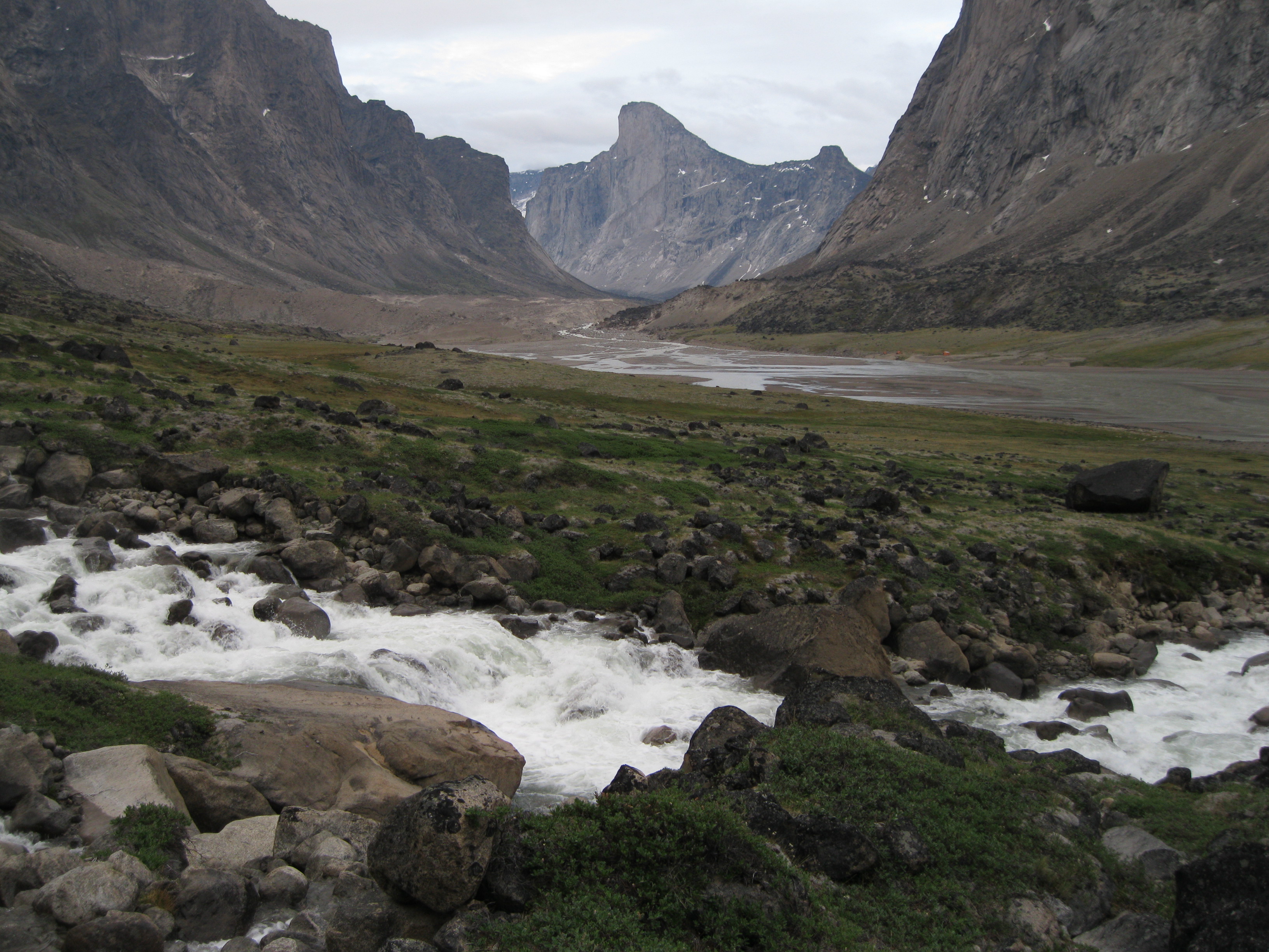
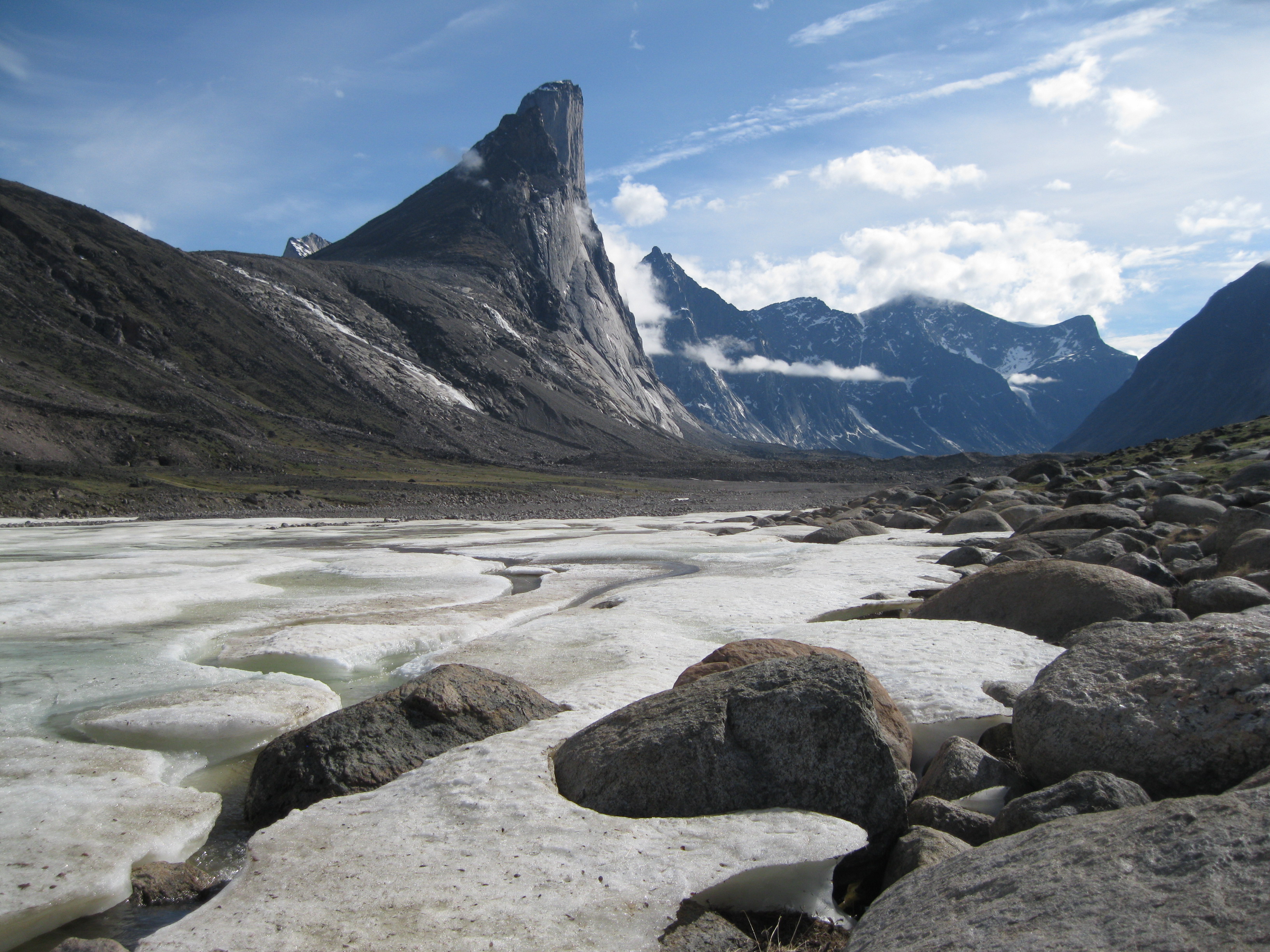
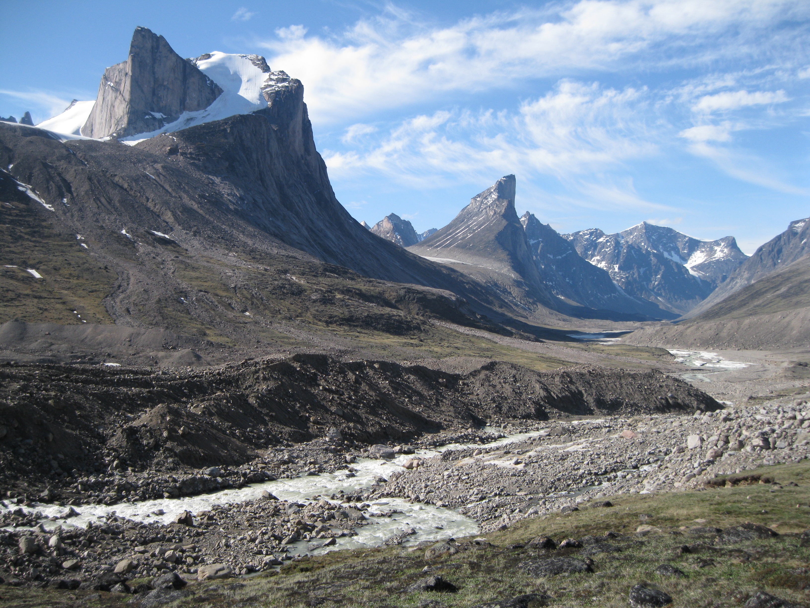
When you arrive at the park you are on the Weasel River. You can explore the park from both sides of the river. If you chose the right side you have the option of checking out the Rock Garden which is located further down the river beyond Schwarzenbach Falls opposite Windy Lake. This is an awesome area with massive boulders, caves and chasms. Staying on this side you will only get a peak of one of the main attractions which is Mount Thor.
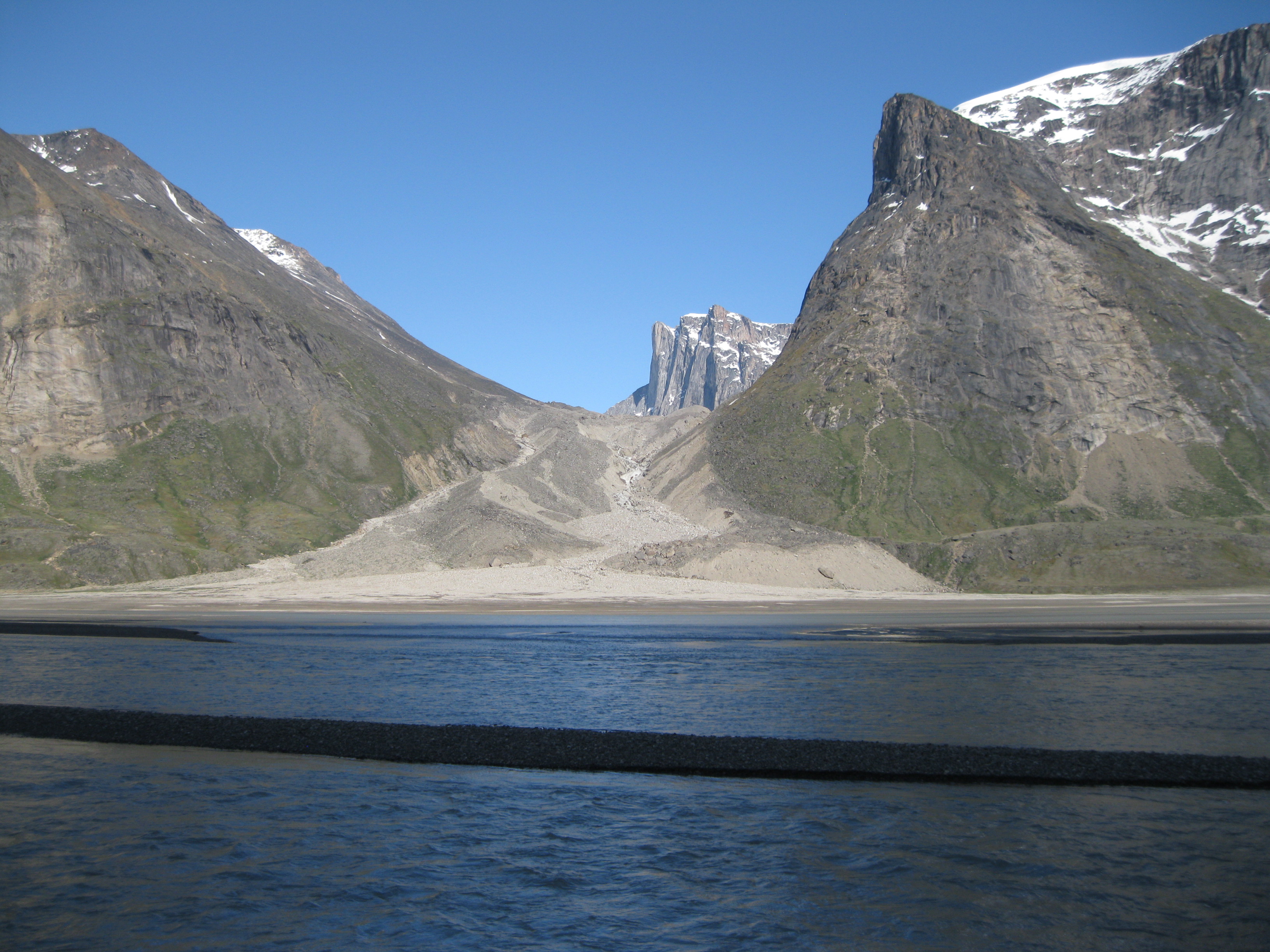
The best option is to commence your trip on the left side as you will have better views and you have the option of exploring the area around Mount Thor and get further into the park. When you arrive at the park entrance you are situated opposite Mount Overlord and will have a stunning view down Akshayuk Pass and the Weasel River where you will be hiking.
Most of the park is covered by the Penny Ice Cap which is pretty much inaccessible, so the place where most people hike is through Akshayuk Pass which is also the most scenic part.
There are no designated camping areas in the park, so you can camp pretty much anywhere you want. There are several emergency shelters, but you are not allowed to use them for camping. These are only to be used in case of emergencies.
From Mount Overlord to Crater Lake
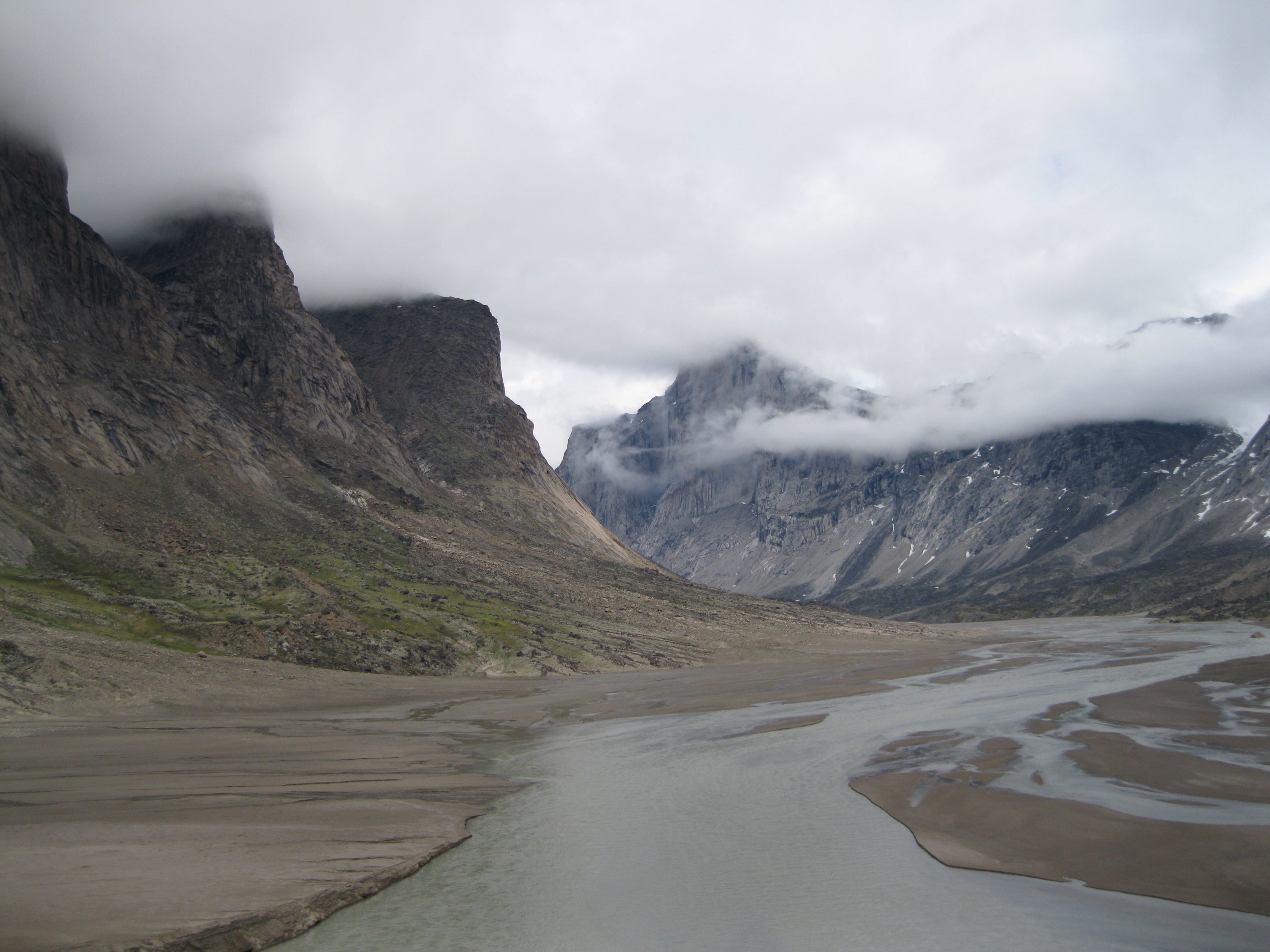
When you start hiking down the Akshayuk Pass it will be on a level surface. The best and easiest way is to walk along the coast. The terrain consists of sand and tundra. Bear in mind, that due to the tide, the sand can be soft in some areas. So be careful of arctic quicksand as it can be a tad dangerous. You can step on sand where you suddenly drop down about 30 centimetres (12 inches) or so.

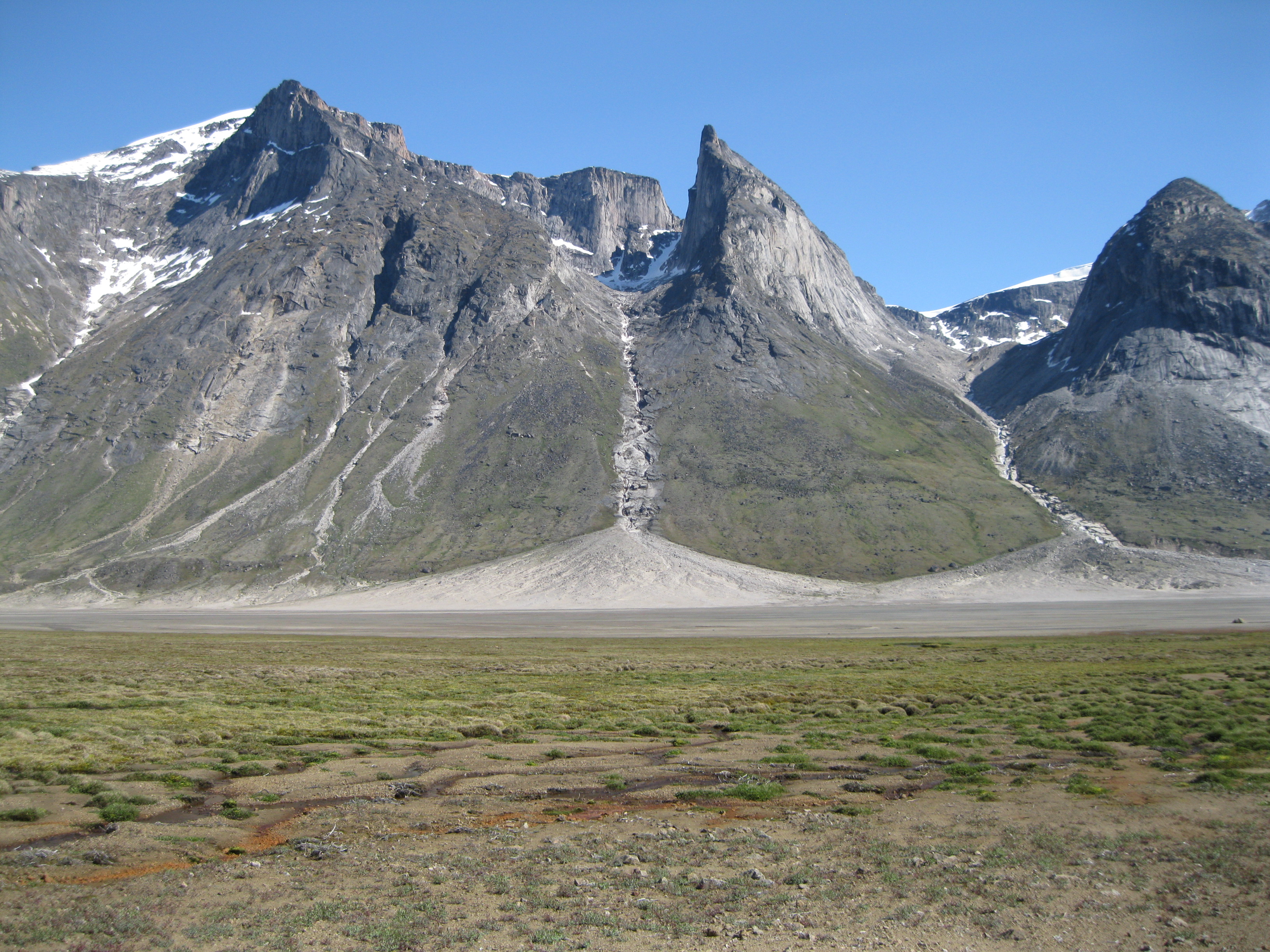
The first part of the walk into the park leads you past Mount Overlord, Mount Ulu, Sandcastle Peak and Turnweather Peak all the way down to Crater Lake is not strenuous at all. The closer you stay to the shoreline, the easier it will be and the moraines you will have to cross are smaller.
It really depends on the load of you backpack. If it is really massively heavy you should take it slow and not do too many kilometres the first couple of days until your pack is lighter after you’ve consumed some of your food. Furthermore remember to take some breaks on the way. Take your pack off, have some water and a snack. Even though it will not be very hot it is still important that you drink a couple of litres of water during the day.

When going on your hike from Mount Overlord you will be approached by stunning scenery from both sides of the Weasel River. You could do the first stretch down to the first emergency shelter known as the Ulu Shelter. Here you will have a great view of Mount Ulu and Turnweather Peak on the opposite side of the river.
If you started your hike from Mount Overlord at around 10:00 or 11:00 in the morning this will be the perfect time for a lunch stop. Even though you are not allowed to camp at the shelters, you can use them as a lunch area. Here you will find a couple of spots where you can have a sit down as well. It’s very nice to sit down with a backrest after carrying a heavy backpack for a while. You could take a chance to register yourself in the visitor book at the shelter.
After lunch you can continue further on and camp down opposite Sandcastle Peak which is a good spot. The terrain down here is similar. Take in the amazing scenery of the valley, the river, flowers, vegetation and the surrounding mountain peaks. An amazing sight! Remember to look back at where you came from. You will see the river and still the fjord where you arrived from.
In general when you camp in the park you have a find an area with a water stream so you have a water source. You can drink the water directly from the streams and it is absolutely yummy. But usd drink the water directly from the streams. You can drink water from the river as well, but better safe than sorry. So use the streams. When you are hiking and you have camping in mind within a short period of time, just look after the glaciers as they will supply a waterfall and a stream further down in an area where you can camp.
The surface for camping will either be rocky soil, tundra or sand. A sandy surface is the best. Find a fairly level spot and camp. It will be good to have a massive boulders in the area too for two reasons. You can get some cover from the wind as it can get pretty windy at times. Furthermore you need a spot where you can do your business so to speak. When you poo, find a boulder a fair bit away from you camp and at least 30 metres (approx 100 feet) from any stream. When you are finished burn your toilet paper. This is important as you should not leave any waste in the park. Please make sure you do this so future generations can enjoy the park without any waste.

When you have set up camp, have a stroll around the area. Check out some of the rock formations and mountain peak and take your time to take some photos. The more you walk around and explore, the more amazing scenery you will see. Again, if you walk out on the sand on the river, do be careful. You can get some good angles of the river here. Take for shots of the streams with the peaks as the backdrop and so on.
The possibilities are endless. Depending on where you are camping and how much time you have, you can walk further up towards the mountains peaks where you will find some cool boulders you can explore and take some amazing shots of.
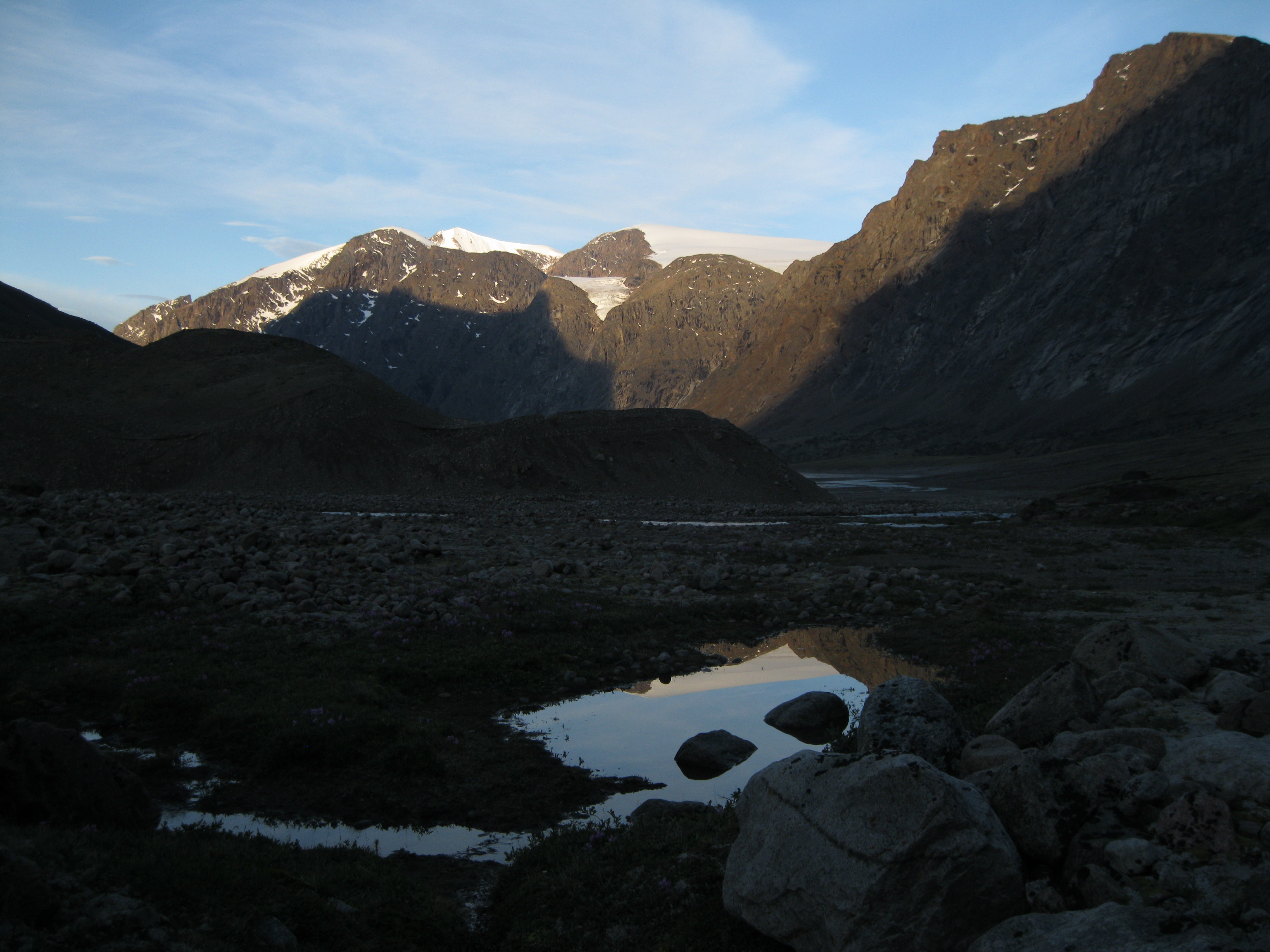
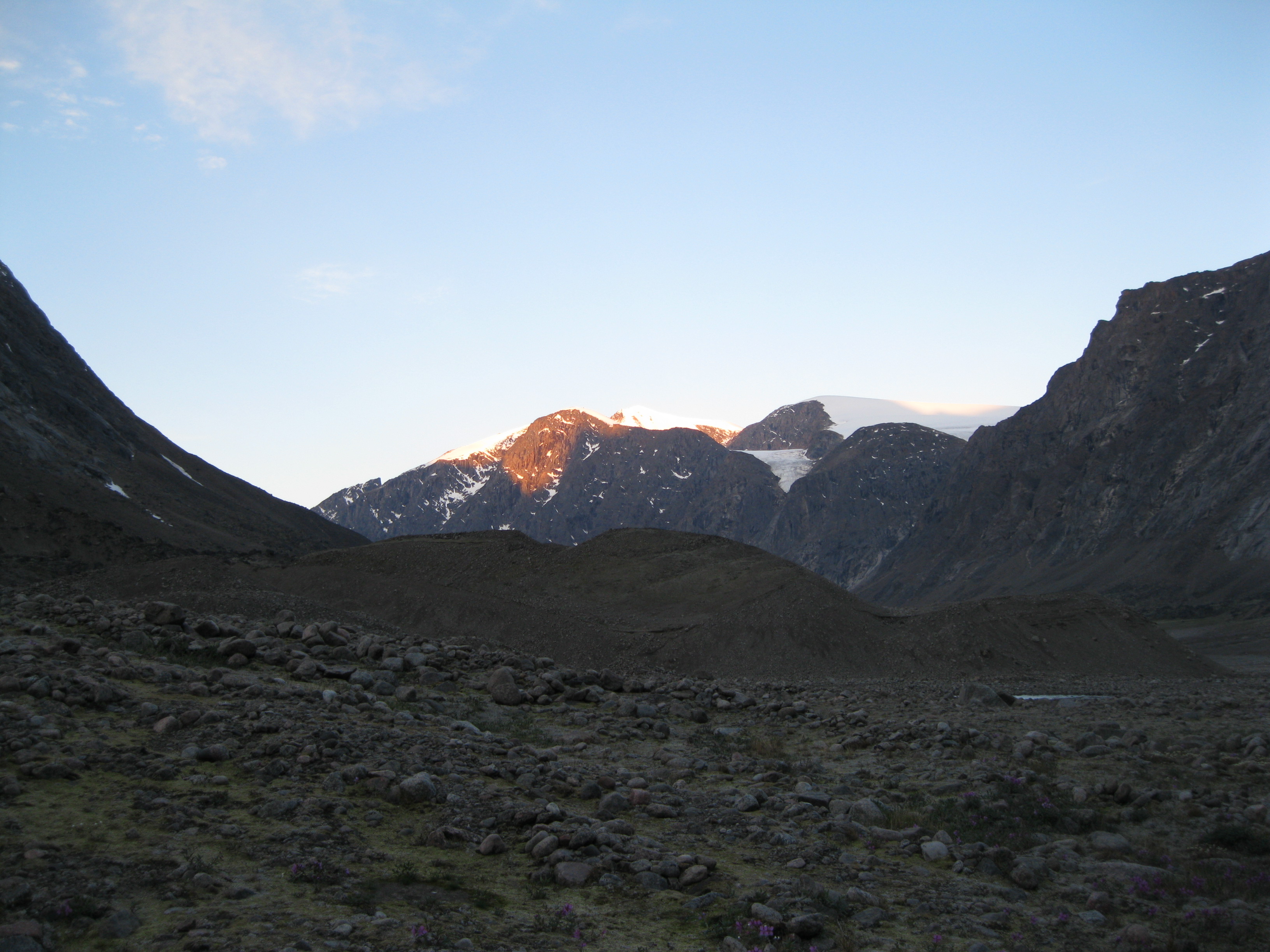
During the evening after you have had dinner, go for a stroll again. You may be lucky to have the reflection of a mountain peak in the river or in a pond or lake. This will be a perfect photo opportunity. It may be the golden hour too where the sun will reflect on the peak and create a golden or red glow which is really stunning.

Furthermore if you get up during the night for a pee, remember to bring your camera as the light may have an amazing reflection on the peaks. It will be light all day and night so you have all sorts of opportunities for great photos. You will also be able to take amazing photos of the scenery during different weather conditions. The shots of the same motif will be completely different from blue skies to cloudy to mist. If you are in the park for 10-15 days you most likely will have types of weather.
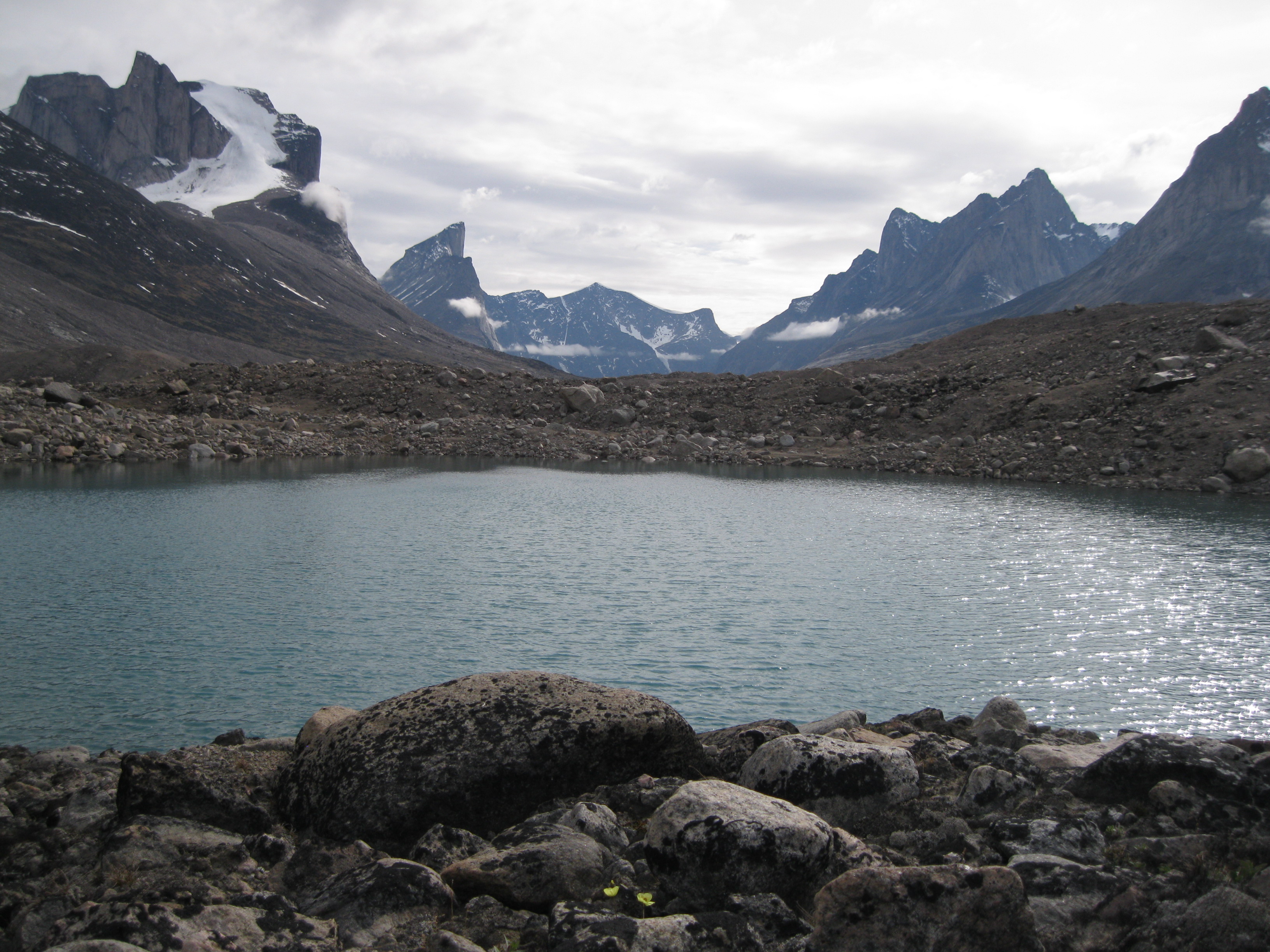
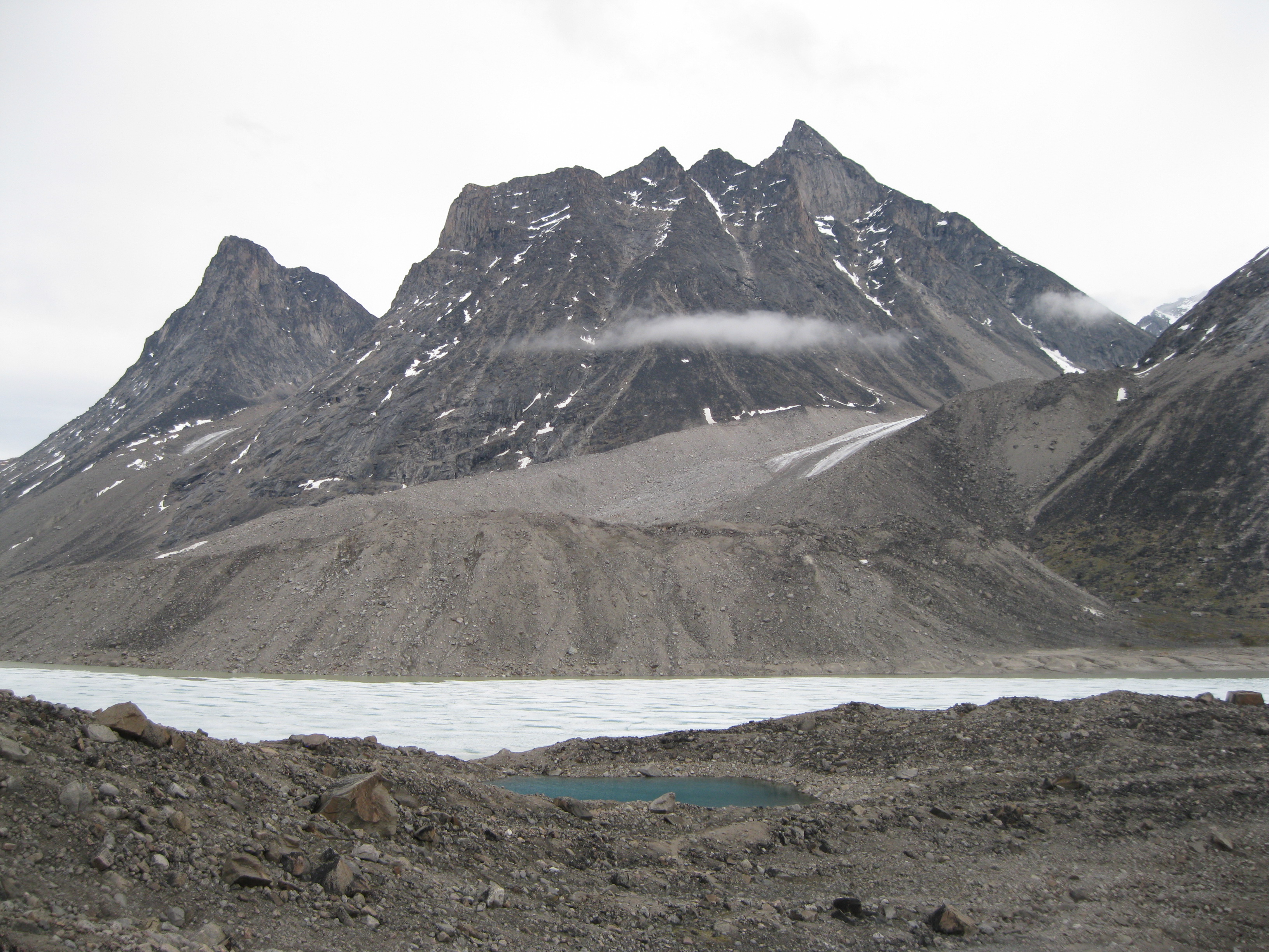
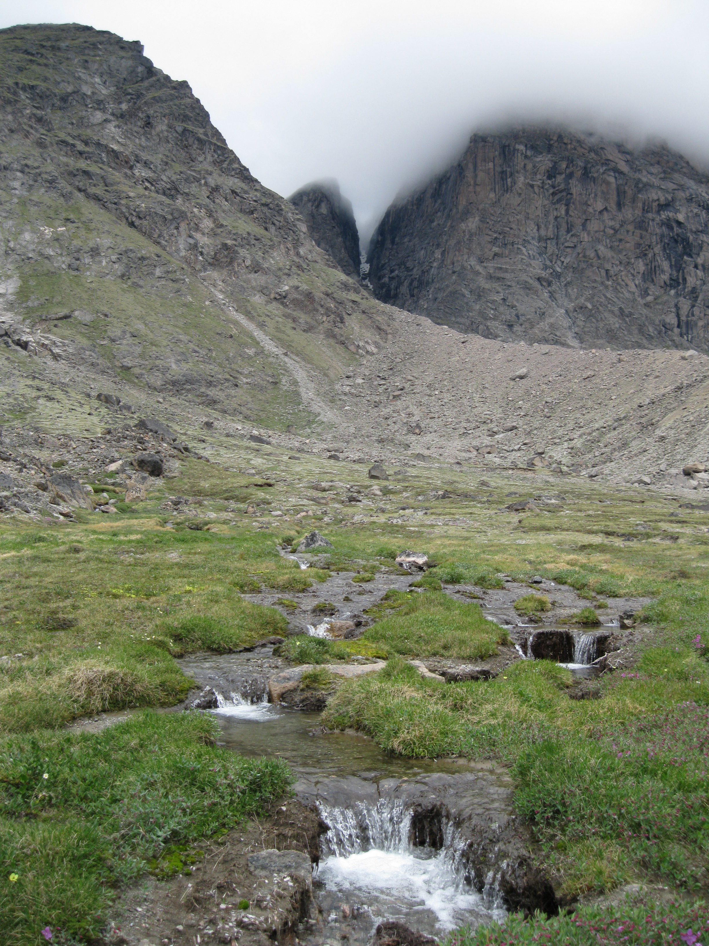
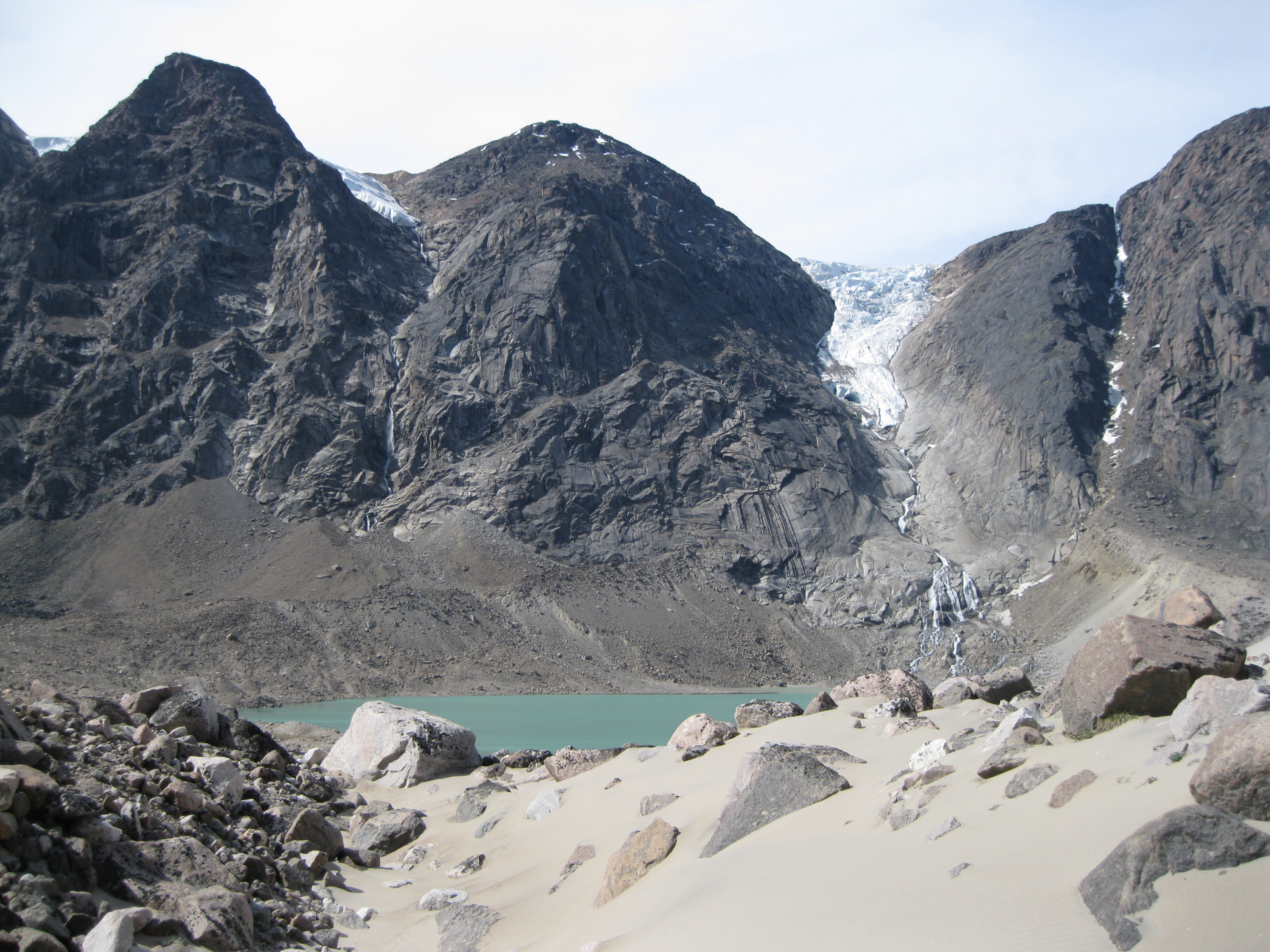
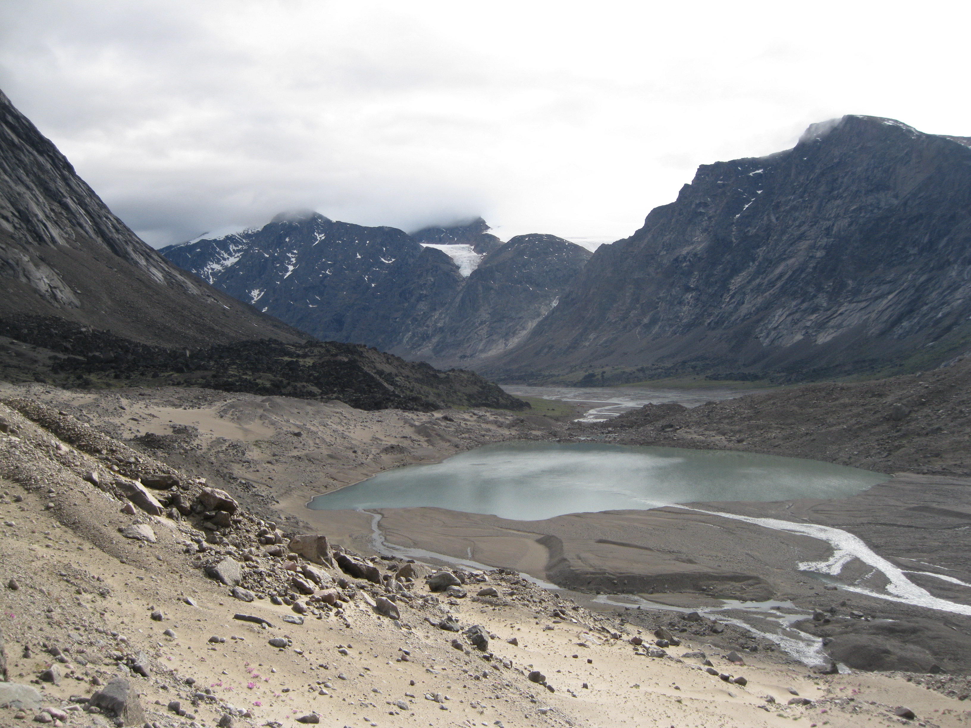
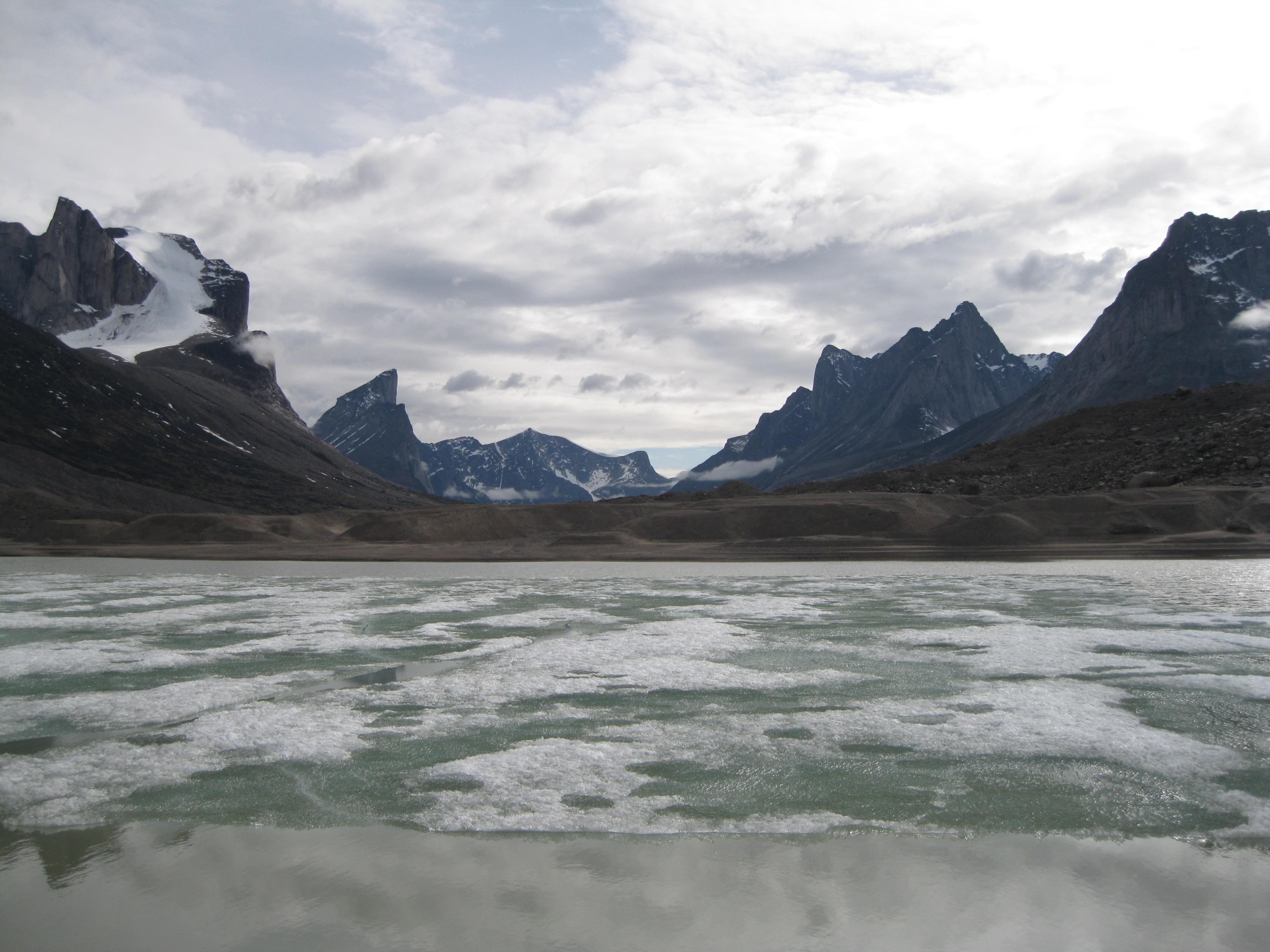
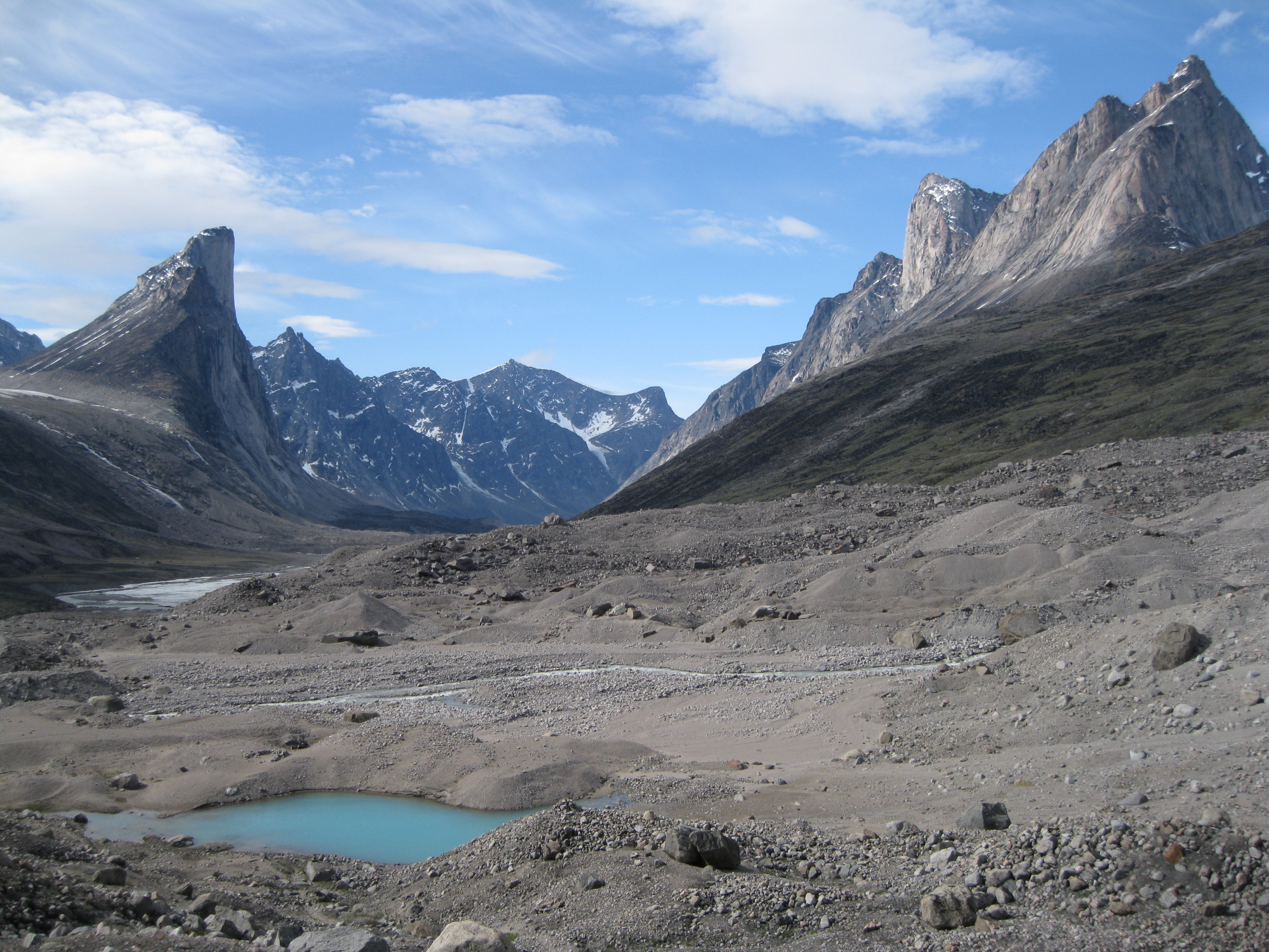
Continuing onwards from Sandcastle Peak, the terrain will be fairly similar to what you have experience so far all the way down to Crater Lake. Bear in mind that the water level can vary a fair bit depending on the tide. That determines how far down along the shore you can walk. The closer you get to Crater Lake the more sandy it gets. You can see a massive gravel pile in the distance which is where you will find Crater Lake. The lake is not really a crater but just looks like one. It is actually a massive moraine from Tumbling Glacier that feeds it.
The Amazing Crater Lake
When you get close to Crater Lake you will have excellent opportunities to take great photos of this massive moraine, Tumbling Glacier in the background and down Weasel River and Akshayuk Pass. At this point you cannot see the lake itself yet. To get to the lake you have to climb the moraine which will be your first major elevation challenge so far. Before climbing it would probably be a good idea to have a break, some water and a snack.
The climb up the moraine to Crater Lake is a tad strenuous especially with a heavy backpack. This obviously depends on your level of fitness but if you are relatively fit, it is actually not too bad. The climb is split into a couple of stages and it will probably take you about 10-15 minutes. This also depends on how much time you spend on taking photos. It is highly recommend that you take your time to have a look around. The scenery is breathtaking everywhere you look. Down Akshayuk Pass and the Weasel River where you came from, when you look up to Tumbling Glacier and beyond the lake.
On the way up to the lake you may find little ponds or streams on the way which will be good shots with the mountains as a backdrop. You will notice on your way up that the terrain changes a bit surprisingly to sand dunes along with moraine rocks a bit reminiscent of a desert. Quite fascinating and beautiful. You can also get great shots of the sand dunes with the mountains as the backdrop.
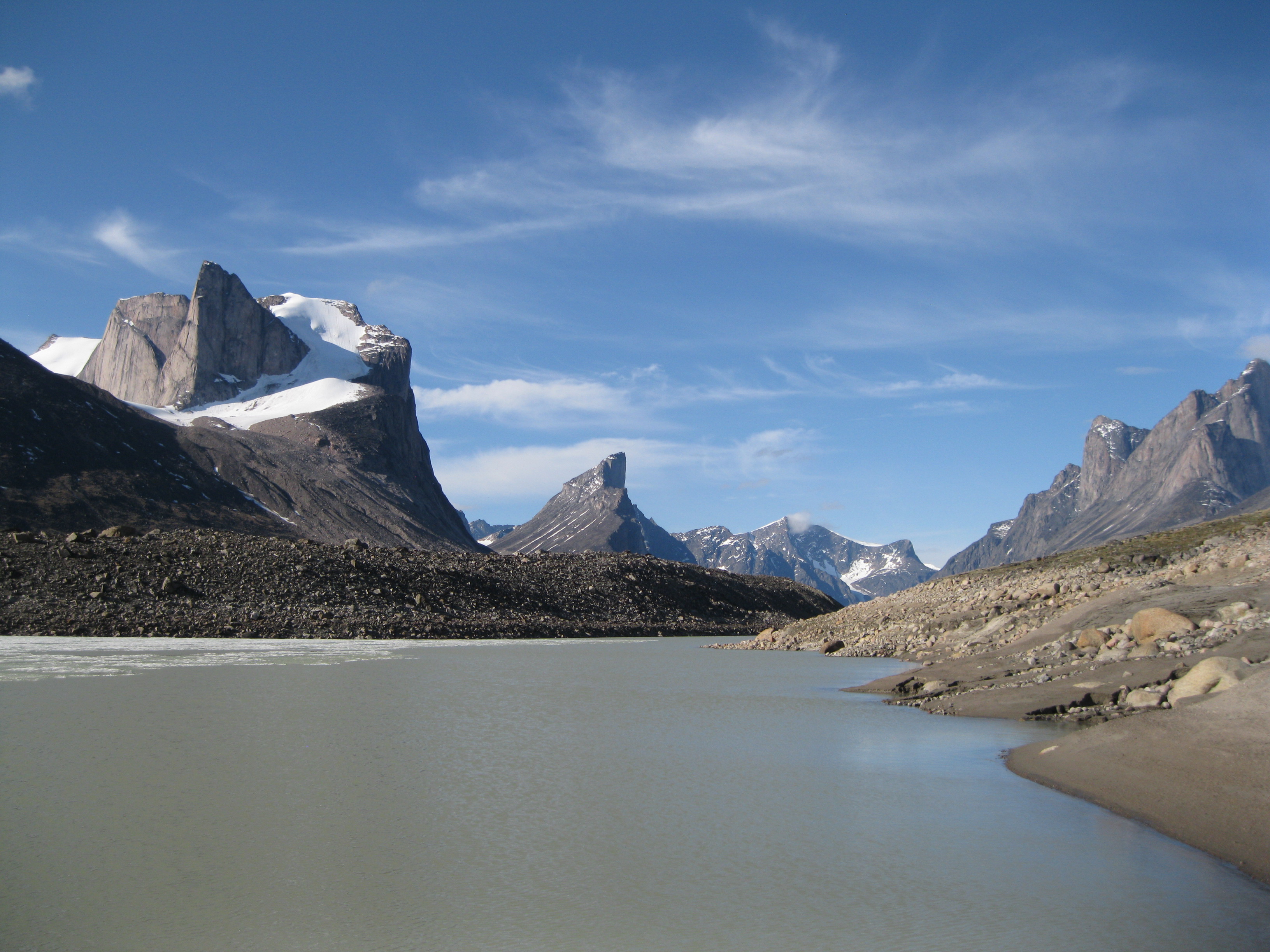
When you get to the top of the moraine you will have an amazing view of Crater Lake. Its stunning turquoise colours look awesome with the mountains and Tumbling Glacier as the backdrop. The beautiful colour is due to the silt in the glacial water. You see similar coloured lakes in the Canadian Rockies but this lake is even more amazing. Take some shots of the lake and Tumbling Glacier from the top. Make your way down to the lake itself and check it out and take some photos. If you take a close look, the lake is shaped a bit like a heart. So you could say it’s Lover’s Lake.
Have a short rest at the top and make you way down on the other side. Here you will be approached by yet another amazing view. This is the continuation of Akshayuk Pass and the Weasel River. In the distance to the left you will see a lush green with a lot of boulders which is a great area to explore. This place has been nicknamed “The Crib” and you will find some amazing rock formations, caves and chasms here. Beyond this area you can see Schwarzenbach Falls as well.
Going down the moraine is not too difficult as long as you use the right technique. Where possible, walk down sideways. This is especially easy and a fast way to get down when it’s in the sand dunes as you can take some massive steps into the sand and more or less slide your way down.
Beyond Crater Lake…Onwards to Schwarzenbach Falls
Once you are down on the other side you will have to make several stream crossings. These streams originate from the Tumbling Glacier and to continue you will have to cross them. Some are easy and you can walk across in your water proof hiking boots or you can jump across on rocks. Be careful and don’t do anything hazardous. If you are the slightest in doubt of your ability to jump across, don’t do it. You do not want to injure yourself especially not out here in the wilderness.
Before going on the hike it is essential that you have shoes for stream crossings. A pair of sneakers are very appropriate for this. You could also use sandals, just make sure they sit firmly around your feet so they don’t fall off in the strong current. As the water in the streams will be freezing cold, as they are feed by the glaciers, it is highly recommended that you wear neoprene socks inside your shoes when crossing. They will keep you warm as long as you don’t get water inside them, if that is possible.
Before you cross the stream, put on your appropriate foot wear and neoprene sooks. Tie your hiking boots onto your backpack, not around your neck. Make sure they are placed so they don’t bother your arms when crossing. Don’t strap on your backpack at your waist or at your chest. Keep these straps untightened in case you fall into the stream when crossing. That way you can work yourself out of the backpack fast and easily.
When crossing where the current is strong, make sure you do it sideways, firmly place your sticks in front of you. Both to check how deep it is but also you get a firm grip, move your right foot first, then move your left foot, alternate this motion until you have crossed. At no time should you cross your feet as this is too dangerous and you could fall over. When you are across, have a short rest and put you hiking boots back on.
The area after the stream crossing at Crater Lake is also a pretty neat lunch spot, if you arrive around that time. You may be lucky to witness a couple of rock slides coming down from Tumbling Glacier. Suddenly you may be standing there and you can just hear this cool cracking sound in the distance. You will see massive rocks falling down and the dust coming up from the bottom at Crater Lake. Awesome!
As you continue further on you will be on a level sandy gravel surface for about 10-15 minutes which is easy to walk on until you reach “The Crib”. To get beyond this green bouldery area you have to climb onto it. You cannot walk around as you will enter the Weasel River if you try. This is a nice little challenge. It can be a bit steep at times as you will be walking at the edges.
You have to be a bit careful as some of the trail has been washed away and the remaining part of the trail is close to the edge. “The Crib” is also a cool area to explore with its massive boulders, caves and chasms. You could do it while walking through or on a half day excursion later. It really depends on whether you want to continue onto an area where you can camp for the night close by.
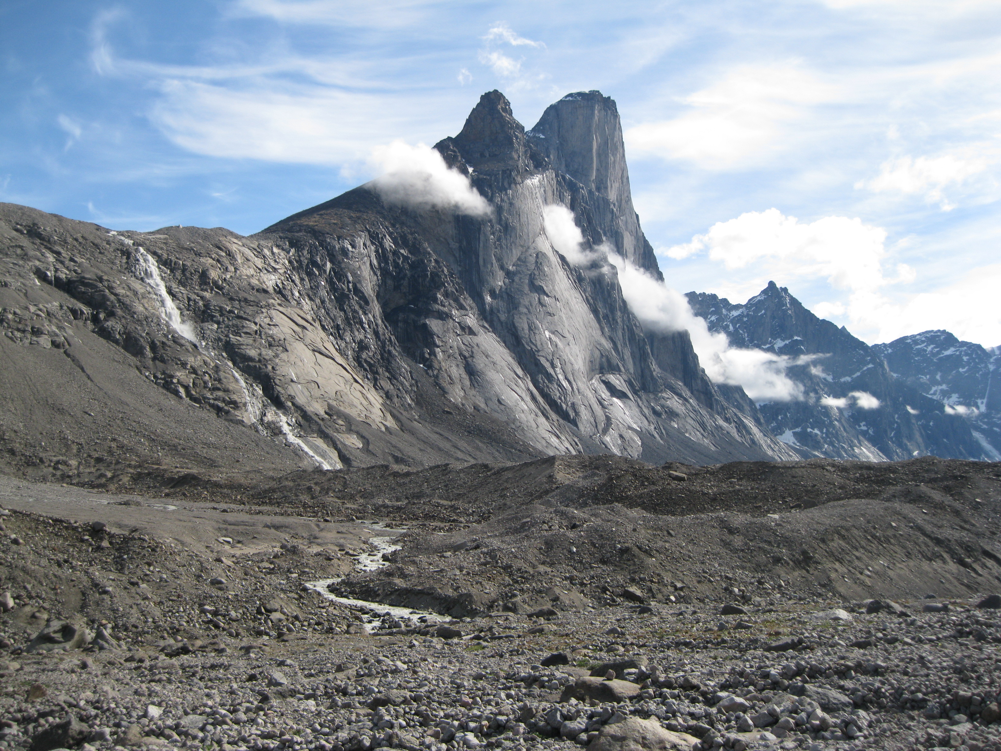
When exploring “The Crib”, take your time. You can go into the different caves and chasms and take photos. You may find a little beautiful pond you can photograph with the mountains or boulders as the backdrops. Take shots of the boulders with the mountains as the backdrop and so on. There are endless possibilities for great photos and a good time. Furthermore when you’re in this area you will get your first peak of Mount Thor just around the corner when looking to your right across the river. Very awesome. Obviously assuming it’s not very misty and you would be able to see Mount Thor at all or the peak.
As this area is elevated you will have great views of Akshayuk Pass, Weasel River, Schwarzenbach Falls and Crater Lake. It’s interesting when you go around and explore the different boulders. Check out the lichens are they are quite beautiful. Most of the boulders are covered in black lichen and you will also find lichens in shades of green, orange and white. It’s quite beautiful and looks pretty cool if you take photos of them up close.
Also note that some of the massive boulders are black with lichen on one side and brown/grey on the other side. Clearly this is rock that has broken of the mountain side within a relatively recent time, as the side of the rock without lichen has been the inside of the rock against the mountain. There are several of cool areas up here. You will find spots with stand-alone boulders and other places where you have a big collection of boulders in one place that has created awesome structures with caves and chasms. This is a great place to explore.
Once you are off “The Crib” you will be on more flat and level terrain which is also lush and green. It’s better to hike as close to the shoreline as possible because it will be on a harder surface as opposed to walking further up toward the mountains which will be on tundra. The latter is quite tiring to walk on as every time you step on it you sink about 10-20 cm (4-8 inches) into the ground due to its softness.
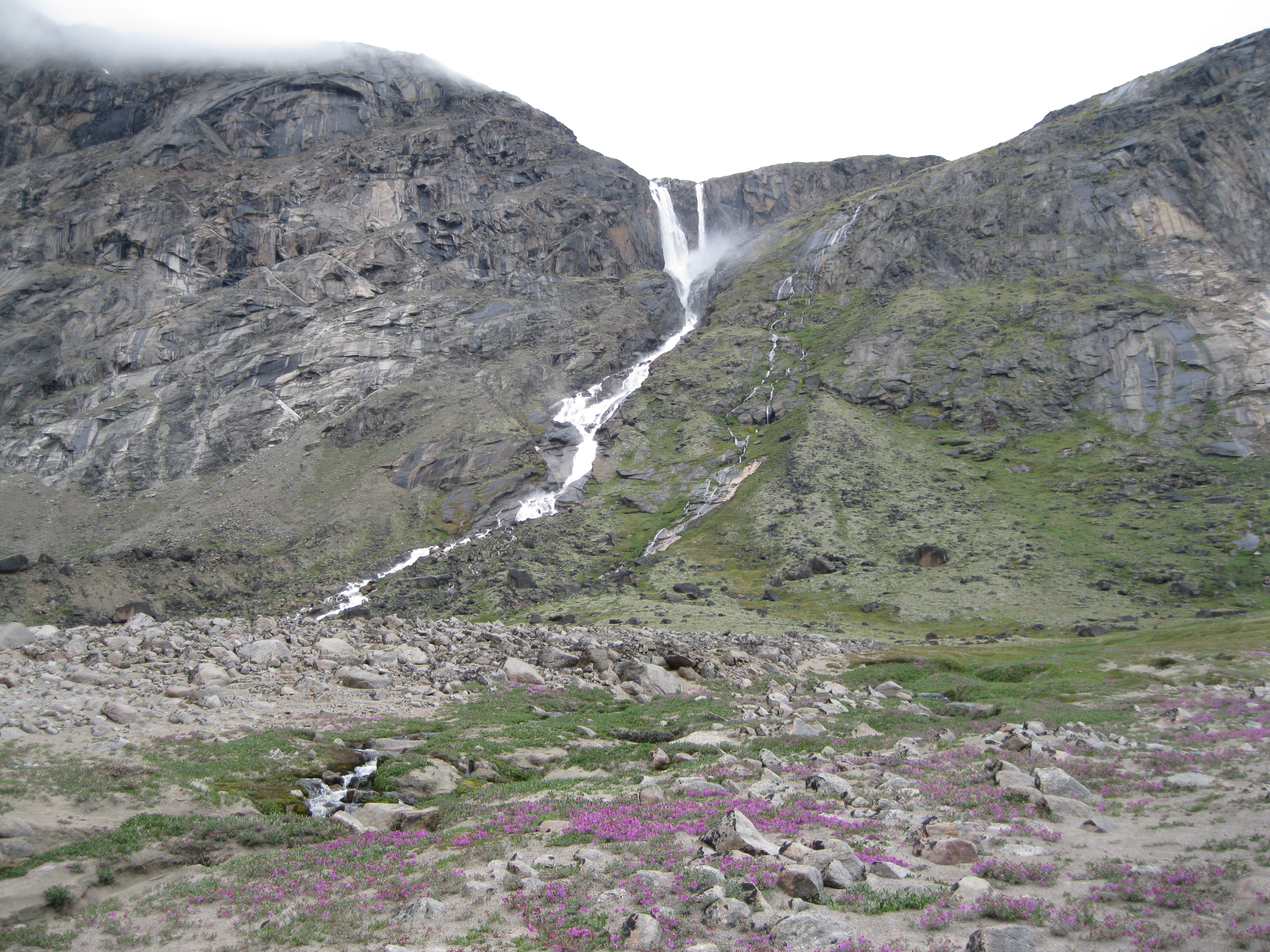
The further you walk, the closer you get to Schwarzenbach Falls and the more you will see more of Mount Thor and range on the other side of the Weasel River. It will probably take you about 15-20 minutes to get to Schwarzenbach Falls. This is a pretty good spot to camp. You can find a level surface on the tundra which is good for setting up the tents. Furthermore you will have to cross the streams at the bottom of Schwarzenbach Falls. The water levels can be a bit high. Depending on whether it will be raining during night, the water level is normally lower in the morning. So it could be an option to camp here and then cross the following morning.
Schwarzenbach Falls was named after Swiss botanist Fritz Hans Schwarzenbach who was exploring the area on an expedition in 1953.
From Schwarzenbach Falls to Windy Lake
Once you have crossed the stream you will have a great view of Schwarzenbach Falls and Mount Thor from a new different angle. Afterwards it would be a perfect opportunity to celebrate the success with a nice breakfast if you crossed in the morning. This will be one of the most challenging crossings in the park. It is not too difficult though so you will be fine. On the other side of the Weasel River you can also see an emergency shelter that lies just before the Rock Garden. When you have crossed Schwarzenbach Falls you have also crossed the Arctic Circle which is pretty cool.

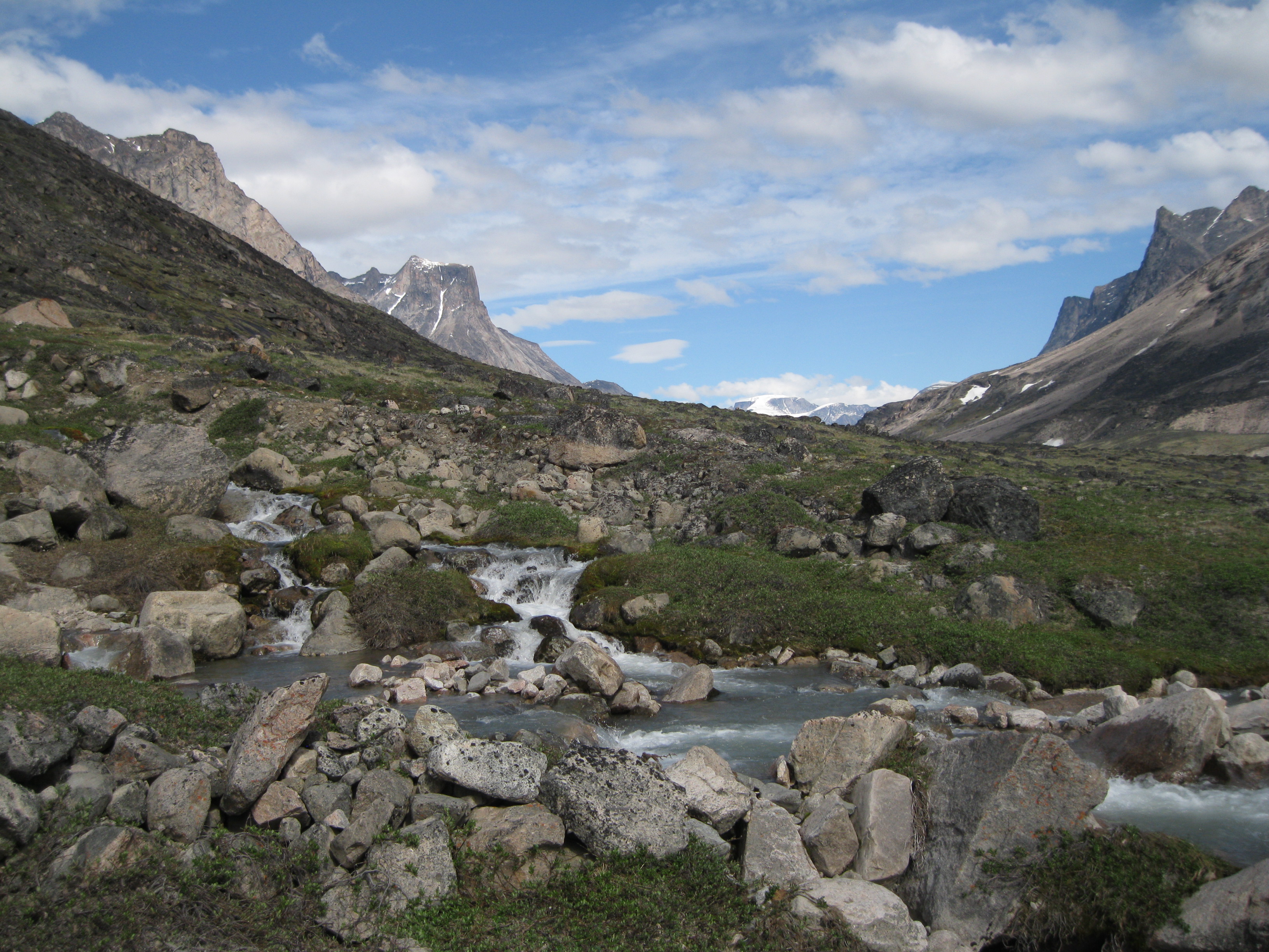
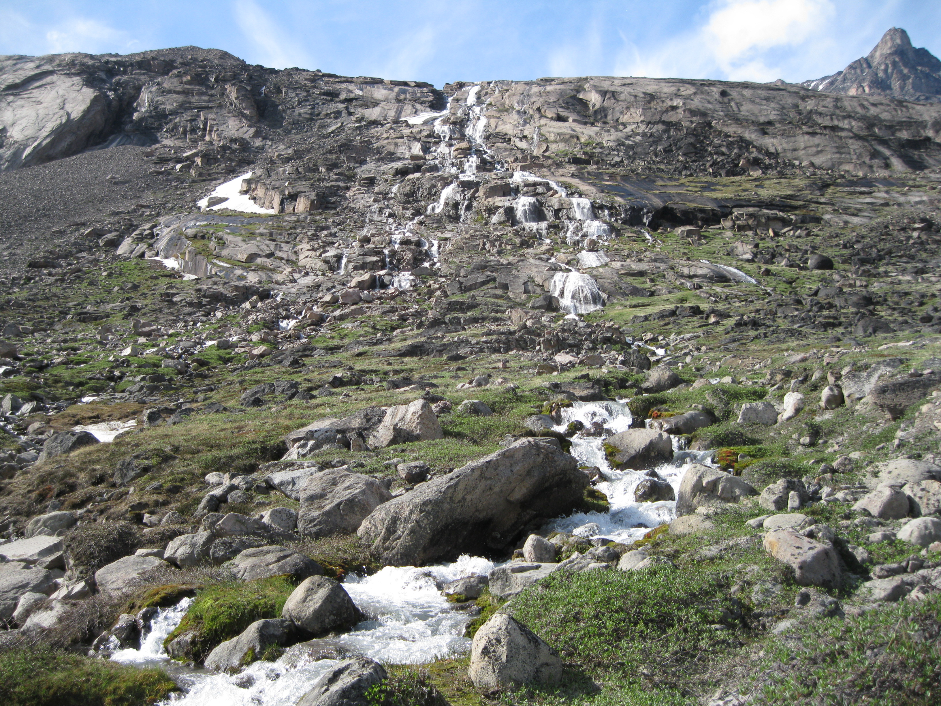
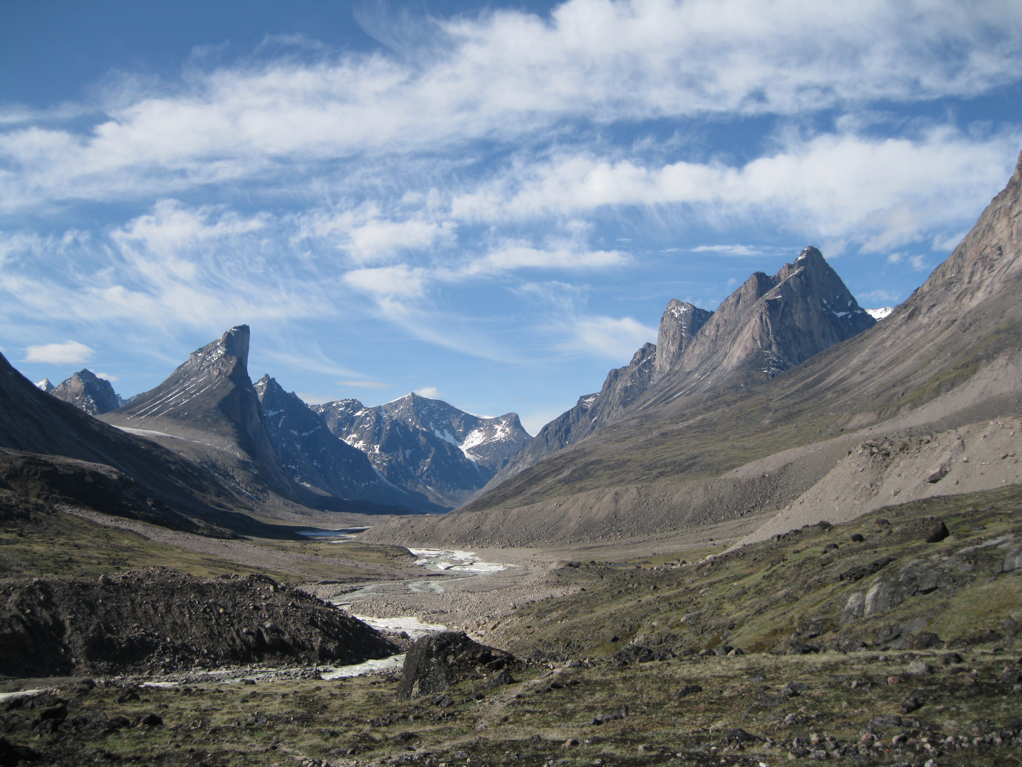
The hike from here goes towards Windy Lake which is based on the top of a big moraine. This a couple of kilometres away and the hike is on a pretty level surface. Also here it’s easier to walk along the shoreline. Not too far from Windy Lake you will find an area with some really beautiful streams and cascades coming down from the mountains towards the river. This is a great photo opportunity and you might as well hit two birds with one stone and have a backpack rest.
Getting up to Windy Lake is a bit of a climb. If you are in fine shape it will not be too strenuous for you. It will be a bit rocky, so do it at a moderate pace. On the way up you may see a pond which will be an awesome photo opportunity against the mountains in the background. When you get to the top you will see the lake and down Akshayuk Pass beyond it towards Mount Thor. Another great spot for photos.
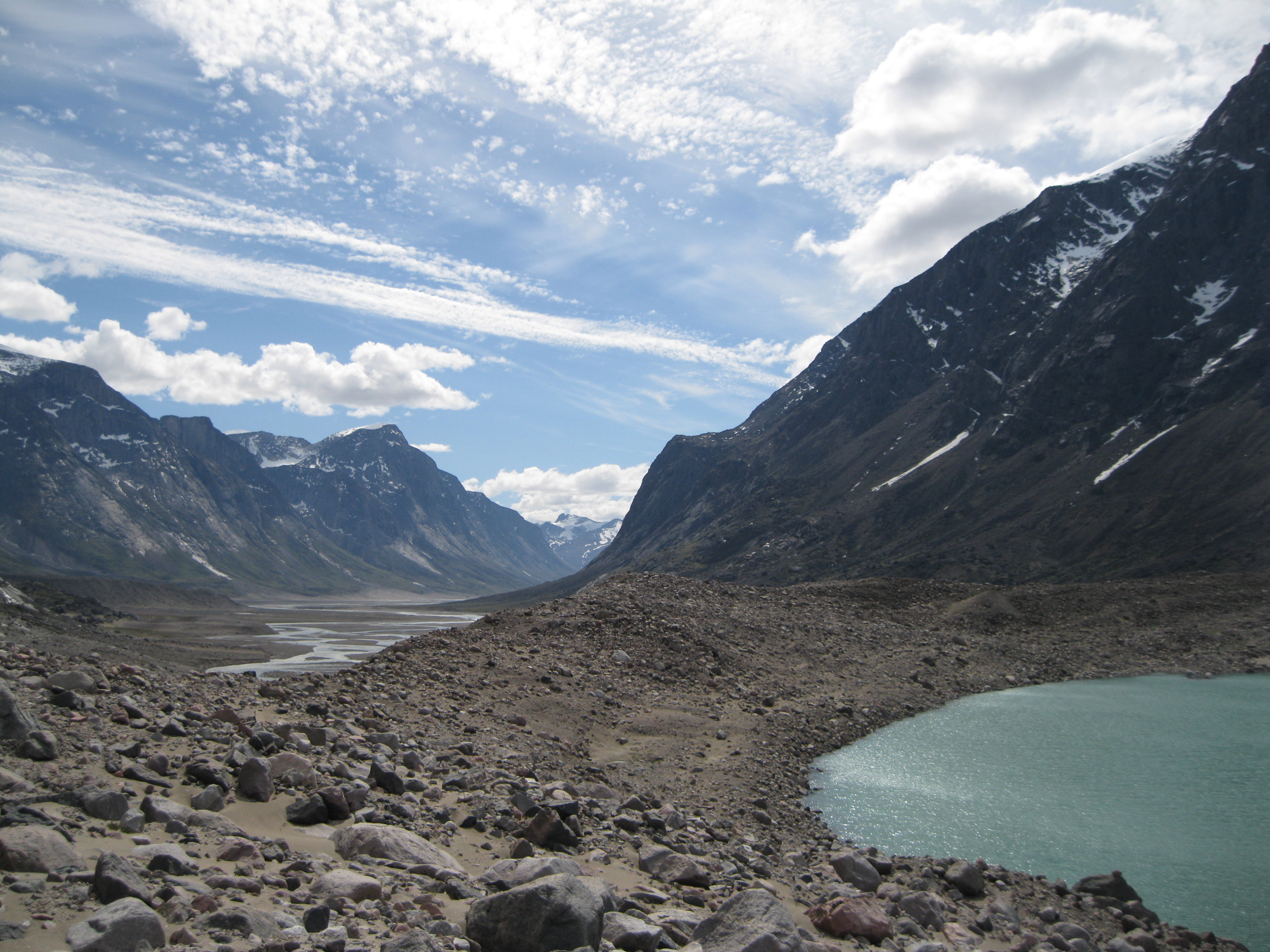
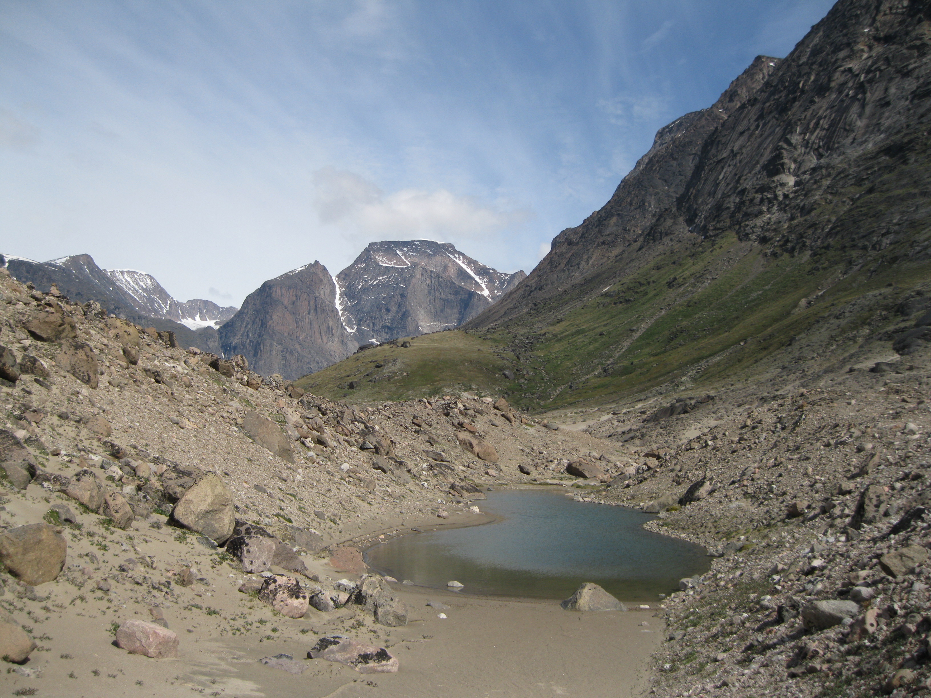
Crossing the Windy Lake moraine is a bit up and down, at this point you will have to walk down towards the lake itself. Both the lake and the pond have beautiful turquoise colours. In the background you will also have the glacier feeding the stream leading down to the lake. Yet another good shot. You will have to cross this stream to continue onwards, most likely in your water shoes as well here. Check if there is anywhere you can cross without changing shoes, if not, change and examine where the best place is to cross.
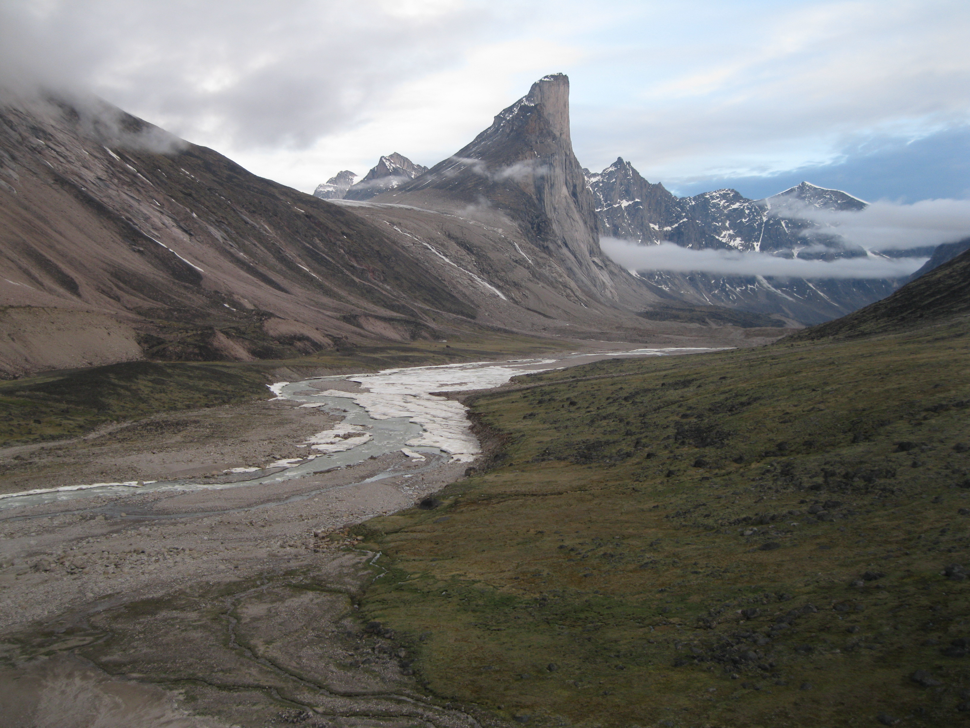
Once you have crossed the stream it will continue to go up and down. On this side there will be sand dunes and also a fair bit rocks. Again, this is a great area for photos in all direction of the sand dunes against the mountains, Mount Thor, the lake and the glacier. When you get to the end of the moraine you will have a stunning sight of Akshayuk Pass, the Weasel River and Mount Thor. This is one of the most impressive views on the whole hike. Take your time to take it all in and get some killer shots. There are a couple of different spots and if you get to one particular on the edge you will have no obstructions when taking pictures of the pass.
Going down the moraine on the other side is pretty fast as it will mainly be on sand, so walk sideways with big steps into the sand so you can more or less slide down. The Weasel River will most likely be pretty dry in the initial part of the trail once you leave the moraine. It obviously depends on the water level of the time you’re there. Again, here you will also have all sorts of opportunities to take great photos – of Mount Thor, the river, the mountains, the glaciers and so on. The park is just amazing in general. No matter where you look you will have stunning beauty.
Heading Towards the Stunning Mount Thor
The hike continues down the shoreline of the river and after about 20 minutes you will get to an area with a fair bit of rocks. Again, the best please to walk is along the shore. Mind you, in this area of the park you begin to have a marked trail for most of the way which is helpful for you to determine the way to go. If there is a trail, use it as it will be the best option. The walk turns a bit around the corner and you will be getting closer and closer to Mount Thor. On the way this rocky terrain you will have to cross some streams and at some of them you most likely will have to cross in your water shoes again.
Once you get beyond the rocky section, your hike will be easier as you will get in to a lush and green area. If you started your day crossing Schwarzenbach Falls you may have arrived around a time which would be suited for setting down camp and since you are in an area with tundra it’s ideal for just that.
You could continue by leaving early the next morning, push through and have your breakfast at the next emergency shelter which is just at the face of Mount Thor. The continuation of the hike is through a terrain of tundra, rocks and has a tad elevation. Bear in mind that trail in some areas have eroded away so you may have to decide on the best route yourself. Again, the closer to the shoreline is better in general.
Look for cairn markers as well to determine the route for you. In Northern Canada cairns are used as markers on hiking trails. Also here you will encounter stream crossings and some of them you may have to cross in you water shoes. You will get to some areas that are slightly elevated where the trail is right on the edge and in some cases the trail either has been eroded away or nearly has. Mind your step and be careful.
When you get to the emergency shelter at the face of Mount Thor, have your breakfast or a snack and a chill. At this shelter you will also be able to have a sit down with back support. Here you will also have an amazing view of Mount Thor and the valley. The further you get into the valley the more amazing scenery opens up.
As you continue from the shelter and onwards you will be hiking away from the shore and further up into a lush and a green area which is really beautiful with boulders and ponds. You will be going through a bit of rocks but the trail is pretty well maintained for most of the way. You could spend some time here as well exploring. You can get some great photos of the boulders and ponds with Mount Thor as the backdrop. When you move on you will get to a point at the end of this green area with a fairly steep descent towards the end. It’s not too strenuous, just be a tad careful.
When you are off this elevated green area you will be back into the open valley. At all times remember to look back towards Mount Thor which you are walking away from now. You are entering a section which is pretty rocky and at times contains a fair bit of moraine but also tundra. These will be stream crossings and at some point you will most likely have to use your water shoes again. You will have scenery of several glaciers, waterfalls, moraines…the end of the valley you are approaching to one side, and Mount Thor to the other side. So beautiful.
Awesome Scenery at Half Mile Creek
As you continue further down the valley you will get to a point of a big moraine which you will have to climb. Depending on your timing you could have lunch before doing this and take your time to check out the scenery. This is a very good spot to do that as it absolutely stunning here…well it is everywhere in the park…but here you have a view of the valley, now with Mount Thor a bit further down from a different angle now…and also the Weasel River, which could still have ice in it as well. It really depends on the time of year you are in the park.
The climb up the moraine is not too strenuous but it is a bit of an elevation. When you get up there you definitely have to use your water shoes to cross Half Mile Creek. You can either stay down at the foot of the moraine and camp, or go up the moraine, cross Half Mile Creek and continue or camp at Half Mile Creek without crossing. It really depends on the water level of the creek. Camping at the creek and crossing the following morning could be a great option as the water level is lower in the morning and the area is sandy and good for camping. Furthermore you are in a bit of a pocket of rocky moraine so it won’t be too windy either.
If you camp on top of the moraine at Half Mile Creek you will have some killer views as well. Some of the best you will get in the park. If you walk up back to the track you came from you will have some great views of Mount Thor and the valley looking in one direction and in the other you will see the continuation of Akshayuk Pass and stunning mountain peaks such as Mount Battle.
Furthermore if you explore to the right of the sandy camp spot you will find a corridor with massive boulders. If you walk in here you will find a big pile of moraine rocks in the direction of where Mount Thor is. You can’t see the mountain and the valley at this point. Climb this moraine. When you get to the very top you will probably have the best view in the park.
This is definitely worth doing and it’s not too strenuous. It will be quite windy up here and you have to be a tad careful as you will be at the very top. Take in the view of the valley, Mount Thor and the other peaks. Absolutely amazing! To the other side you will see Half Mile Creek, the Highway Glacier, Mount Battle, other peaks and area of the valley you will be hiking into the following day. Very cool. Take your time up here and take some fantastic photos of the scenery.
Exploring Summit Lake And More…
Next morning after you have successfully have crossed Half Mile Creek you will be on your way towards Summit Lake. You will continue hiking along the Weasel River and when getting towards the lake, the elevation is slightly higher and the river may be iced up which will create some great photo ops for you. The trail is still well marked and you will be crossing through rocky areas. New amazing mountain peaks will appear, Mount Thor will be further away, but still a great view and shot with the surrounding mountain peaks and the river.
When you arrive at Summit Lake there will be yet another emergency shelter. You could set up camp here. It can be quite windy though. If you have left Half Mile Creek in the morning you will probably be arriving here before lunch time. You have several options. Either you can do a day hike to Mount Asgard which is a fair bit of a walk or you can continue the walk to check out Summit Lake which is just on the other side of the moraine where the emergency shelter is.
It really depends on the weather. If there is an overcast you may not be able to see Mount Asgard anyway, so checking out Summit Lake is awesome as well. If you do the latter, it will be a half day hike and you can do it without the heavy backpacks. Remember your water shoes as you most likely will be crossing streams to get there. When walking around the park you will notice a lot of beautiful artic flowers. At Summit Lake you will notice the appearance of the Purple Saxifrage which is a really beautiful flower.
If you decide to do Summit Lake go down towards the end of the moraine and climb it. From here you will get from great views of both sides of the valley. Yet another great spot for great photos. You will see the Weasel River, Mount Thor and the surrounding peaks to one side. To the other side, Summit Lake, the Highway Glacier, Mount Battle and other amazing peaks are on display.
When you are walking down the moraine towards Summit Lake it will be on very rocky terrain and in some areas there will be massive boulders. So it is a bit challenging but if you are an experience hiker this will be fairly easy for you. You will be crossing some steams and most likely you will have to use your water shoes as the steams are fed by the big Caribou Glacier.
You will have some great views of this glacier, other glaciers, streams, ponds, moraines, Mount Thor, Mount Battle and Summit Lake. Absolutely stunning. When you get to Summit Lake take your time to take all in. This may be a great opportunity to have a snack and a chill and have lunch. There should be a great spot somewhere among the boulders where it won’t be too windy. Depending on the time of year, the lake may be iced up so which will be a great view with the Highway Glacier and Mount Battle as the backdrop.
Afterwards you could return to camp. On your way back, you will get all sorts of great opportunities to take amazing photos of Breidablik Peak and Mount Thor fronted by ponds, Lake Summit, moraines and boulders. You will also see some cool sand dunes along the lake. But you can also take great shots against the other peaks.
At the emergency shelter there are a couple of chairs as well. Not only is it nice to have a chill here after the hike with a backrest but you will also have one of the best views in the park here. An amazing view down Akshayuk Pass, Weasel River and Mount Thor surrounded by other stunning peaks. Absolutely fantastic.
Heading Back…
If you are not doing hike all the way through the park to the north side, this is the point where you will turn back which you will be doing the following day. So you will have the same view on the way back just from the opposite direction. Going back will be much easier and faster as you will have a much lighter backpack. The great thing about doing the same route back is that if you were unlucky with having an overcast in some areas going in, you may have blue skies this time and you may see something you didn’t see the first time around. The return can be done in about four days.
On your way back, try to camp at different spots as opposed to when you walked in as this will give you a different perspective. Also when you’ve set camp and you want to walk around and explore a bit in the evening it will be in a different area. If you take your time and check out the scenery after camp has been set up you can take some interesting abstract photos. It could be of a massive boulder against the mountains or of flowers against a stream and the mountain. Only your imagination is your limitation.
The day before you get to the entrance of the park, you should call for a pick and arrange the time. It would be a good idea to camp close to this point so you will be sure to be there on time the following day. Going back in the boat to Pang, you will yet again have an amazing view of the Pangnirtung Fjord this time in the opposite direction than when you arrived. Awesome.